Property Record
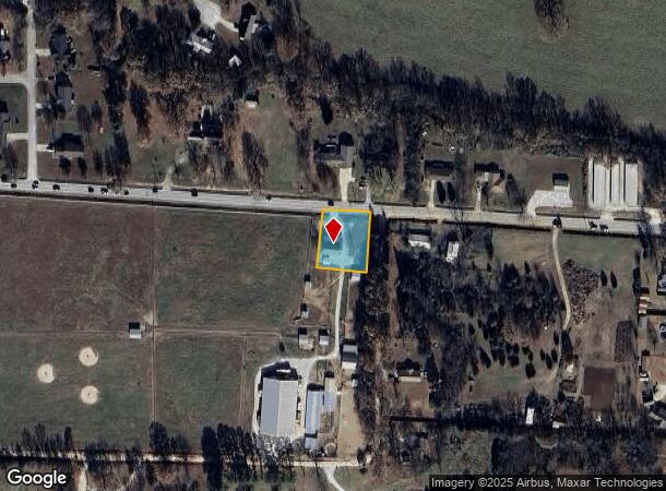
3945 Highway 392 W, Harrison, AR 72601
NEARBY LISTINGS FOR SALE OR LEASE
-
-
View all Harrison listings for sale on LoopNet.com
Property Detail
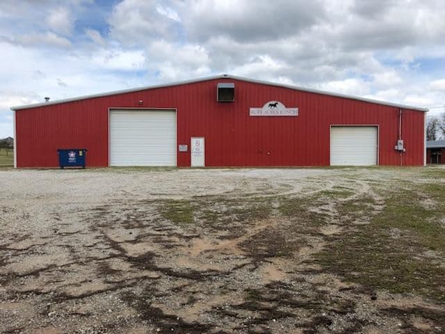
3945 Highway 392 W
021-06463-001C
Rock Island Right Of Way Subdivision
Officebuilding
PT NW NW (.45AC)
X
Boone
05009C0260D
Arkansas
2025
0.45 AC
2025
Arkansas North Area
790400
Other Market Areas
2,025 SF
Harrison, AR
DEMOGRAPHICS near 3945 Highway 392 W
1 Mile
3 Mile
5 Mile
2024 Total Population
326
7,865
18,726
2029 Population
339
8,234
19,646
Pop Growth 2024-2029
+ 3.99%
+ 4.69%
+ 4.91%
Average Age
44
43
42
2024 Total Households
134
3,241
8,013
HH Growth 2024-2029
+ 4.48%
+ 4.66%
+ 4.90%
Median Household Inc
$50,357
$57,694
$44,674
Avg Household Size
2.40
2.40
2.30
2024 Avg HH Vehicles
2.00
2.00
2.00
Median Home Value
$194,999
$162,117
$154,289
Median Year Built
1981
1980
1979
Nearby Places
Map Layers
Map Styles
 Street
 Aerial
- Restaurants
- Banks
- Shops
- Fitness
- Groceries
SALE & LEASE HISTORY
LISTING DATE
SALE/LEASE

May 07, 2018
For Sale
Nearby Properties
Address
Land Use
TOTAL SIZE
Lot Size
Zoning
Address
Land Use
TOTAL SIZE
Lot Size
Zoning
67,401 SF
16.78 AC
Address
Land Use
TOTAL SIZE
Lot Size
Zoning
232,420 SF
37.42 AC
Address
Land Use
TOTAL SIZE
Lot Size
Zoning
177,565 SF
46.52 AC
Address
Land Use
TOTAL SIZE
Lot Size
Zoning
20,198 SF
49.84 AC
Address
Land Use
TOTAL SIZE
Lot Size
Zoning
175,150 SF
10.96 AC
Address
Land Use
TOTAL SIZE
Lot Size
Zoning
235,434 SF
35.78 AC
Address
Land Use
TOTAL SIZE
Lot Size
Zoning
38,680 SF
4.74 AC
Address
Land Use
TOTAL SIZE
Lot Size
Zoning
61,659 SF
20 AC
Address
Land Use
TOTAL SIZE
Lot Size
Zoning
46,508 SF
20.90 AC
Address
Land Use
TOTAL SIZE
Lot Size
Zoning
8,784 SF
3.60 AC
Address
Land Use
TOTAL SIZE
Lot Size
Zoning
4,471 SF
3.14 AC
Address
Land Use
TOTAL SIZE
Lot Size
Zoning
10,744 SF
1.67 AC
Address
Land Use
TOTAL SIZE
Lot Size
Zoning
53,886 SF
2.76 AC
Address
Land Use
TOTAL SIZE
Lot Size
Zoning
37,459 SF
9.25 AC
Address
Land Use
TOTAL SIZE
Lot Size
Zoning
100,000 SF
9.08 AC
Address
Land Use
TOTAL SIZE
Lot Size
Zoning
143,918 SF
27.86 AC
Address
Land Use
TOTAL SIZE
Lot Size
Zoning
6,762 SF
2.30 AC
Address
Land Use
TOTAL SIZE
Lot Size
Zoning
9,138 SF
4.71 AC
Address
Land Use
TOTAL SIZE
Lot Size
Zoning
89,910 SF
9.20 AC
Address
Land Use
TOTAL SIZE
Lot Size
Zoning
8,600 SF
1.78 AC
Address
Land Use
TOTAL SIZE
Lot Size
Zoning
8,787 SF
2.13 AC
Address
Land Use
TOTAL SIZE
Lot Size
Zoning
130,990 SF
8.50 AC
Address
Land Use
TOTAL SIZE
Lot Size
Zoning
22,164 SF
1.96 AC
Address
Land Use
TOTAL SIZE
Lot Size
Zoning
4,096 SF
1.46 AC
Address
Land Use
TOTAL SIZE
Lot Size
Zoning
36,366 SF
5.70 AC
Address
Land Use
TOTAL SIZE
Lot Size
Zoning
18,619 SF
3 AC
Address
Land Use
TOTAL SIZE
Lot Size
Zoning
54,800 SF
8.50 AC
Address
Land Use
TOTAL SIZE
Lot Size
Zoning
7,321 SF
17.11 AC
Address
Land Use
TOTAL SIZE
Lot Size
Zoning
10,860 SF
0.34 AC
The World's #1 Commercial Real Estate Marketplace
Connect with us
© 2026 CoStar Group
The information above has been obtained from sources believed reliable. While we do not doubt its accuracy we have not verified it and make no guarantee, warranty or representation about it. It is your responsibility to independently confirm its accuracy and completeness. Any projections, opinions, assumptions, or estimates used are for example only and do not represent the current or future performance of the property. The value of this transaction to you depends on tax and other factors which should be evaluated by your tax, financial, and legal advisors. You and your advisors should conduct a careful, independent investigation of the property to determine to your satisfaction the suitability of the property for your needs.