Property Record
3945 Pointe West Pl, Rapid City, SD 57702
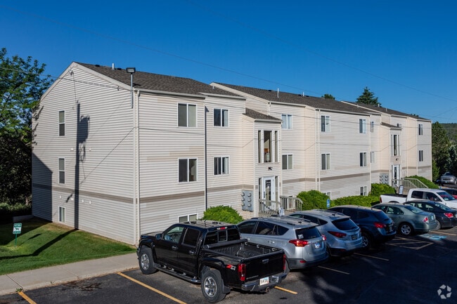


Property Detail
3945 Pointe West Pl
Rapid City, SD
WESTERN HEIGHTS SUBD, BLOCK 4, LOT 6 - 11R
3704329023
Pennington
Multifamilydwelling
South Dakota
2025
6-11
2025
7.92 AC
011100
Rapid City
5,448 SF
Other Market Areas
NEARBY LISTINGS FOR SALE OR LEASE
DEMOGRAPHICS near 3945 Pointe West Pl
1 mile
3 mile
5 mile
2025 Total Population
7,126
27,831
74,580
2030 Population
7,361
28,784
77,479
Pop Growth 2025-2030
+ 3.30%
+ 3.42%
+ 3.89%
Average Age
41
44
42
2025 Total Households
3,293
12,449
31,611
HH Growth 2025-2030
+ 3.61%
+ 3.74%
+ 4.16%
Median Household Inc
$70,925
$78,022
$70,956
Avg Household Size
2.10
2.10
2.20
2025 Avg HH Vehicles
2.00
2.00
2.00
Median Home Value
$294,648
$343,635
$314,269
Median Year Built
1970
1974
1979
Nearby Places
Map Layers
Map Styles
 Street
 Aerial
Layers
 Traffic
 Biking
Places
Listings with unknown addresses are not visible on the map
- Restaurants
- Banks
- Shops
- Fitness
- Groceries
PUBLIC TRANSPORTATION
AIRPORT
Rapid City Regional
Drive
Walk
Distance
Rapid City Regional
27 min
14.2 mi
Freight Ports
Tulsa Port Of Catoosa
Drive
Walk
Distance
Tulsa Port Of Catoosa
975 min
893.6 mi
Nearby Properties
Address
Land Use
TOTAL SIZE
Lot Size
Zoning
Address
Land Use
TOTAL SIZE
Lot Size
Zoning
5,244 SF
17.53 AC
Address
Land Use
TOTAL SIZE
Lot Size
Zoning
40,853 SF
8.09 AC
Address
Land Use
TOTAL SIZE
Lot Size
Zoning
48,204 SF
15.19 AC
Address
Land Use
TOTAL SIZE
Lot Size
Zoning
6,820 SF
10.60 AC
Address
Land Use
TOTAL SIZE
Lot Size
Zoning
48,108 SF
38.14 AC
Address
Land Use
TOTAL SIZE
Lot Size
Zoning
26,807 SF
0.58 AC
Address
Land Use
TOTAL SIZE
Lot Size
Zoning
7,680 SF
9.34 AC
Address
Land Use
TOTAL SIZE
Lot Size
Zoning
14,360 SF
2.07 AC
Address
Land Use
TOTAL SIZE
Lot Size
Zoning
25,762 SF
5.74 AC
Address
Land Use
TOTAL SIZE
Lot Size
Zoning
46,025 SF
36.26 AC
Address
Land Use
TOTAL SIZE
Lot Size
Zoning
35,999 SF
3.01 AC
Address
Land Use
TOTAL SIZE
Lot Size
Zoning
105,621 SF
10 AC
Address
Land Use
TOTAL SIZE
Lot Size
Zoning
3,008 SF
4.66 AC
Address
Land Use
TOTAL SIZE
Lot Size
Zoning
30,740 SF
3.22 AC
Address
Land Use
TOTAL SIZE
Lot Size
Zoning
23,089 SF
0.30 AC
Address
Land Use
TOTAL SIZE
Lot Size
Zoning
48,786 SF
5 AC
Address
Land Use
TOTAL SIZE
Lot Size
Zoning
19,170 SF
1.28 AC
Address
Land Use
TOTAL SIZE
Lot Size
Zoning
9,395 SF
3.26 AC
Address
Land Use
TOTAL SIZE
Lot Size
Zoning
19,302 SF
4.74 AC
Address
Land Use
TOTAL SIZE
Lot Size
Zoning
21,722 SF
7.50 AC
Address
Land Use
TOTAL SIZE
Lot Size
Zoning
24,609 SF
0.46 AC
Address
Land Use
TOTAL SIZE
Lot Size
Zoning
15,407 SF
4.83 AC
Address
Land Use
TOTAL SIZE
Lot Size
Zoning
10,455 SF
0.24 AC
Address
Land Use
TOTAL SIZE
Lot Size
Zoning
5,412 SF
2.03 AC
Address
Land Use
TOTAL SIZE
Lot Size
Zoning
15,217 SF
1.55 AC
Address
Land Use
TOTAL SIZE
Lot Size
Zoning
9,934 SF
1.34 AC
Address
Land Use
TOTAL SIZE
Lot Size
Zoning
1,376 SF
260.54 AC
Address
Land Use
TOTAL SIZE
Lot Size
Zoning
27,807 SF
3.63 AC
Address
Land Use
TOTAL SIZE
Lot Size
Zoning
7,348 SF
9.77 AC
The World's #1 Commercial Real Estate Marketplace
Connect with us
© 2026 CoStar Group
The information above has been obtained from sources believed reliable. While we do not doubt its accuracy we have not verified it and make no guarantee, warranty or representation about it. It is your responsibility to independently confirm its accuracy and completeness. Any projections, opinions, assumptions, or estimates used are for example only and do not represent the current or future performance of the property. The value of this transaction to you depends on tax and other factors which should be evaluated by your tax, financial, and legal advisors. You and your advisors should conduct a careful, independent investigation of the property to determine to your satisfaction the suitability of the property for your needs.