Property Record
39475 Ann Arbor Rd E, Plymouth, MI 48170
NEARBY LISTINGS FOR SALE OR LEASE
Property Detail
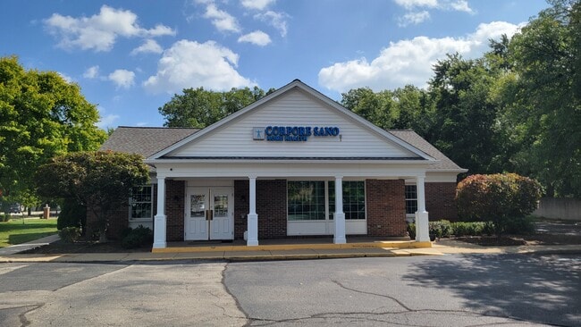
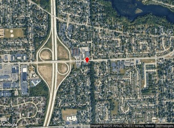
39475 Ann Arbor Rd E
Detroit-Warren-Dearborn, MI
Cambridge Village
78-066-01-0126-000
36MOLA CAMBRIDGE VILLAGE SUBDIVISION T1S R8E L91 P36 TO 38 WCR OUTLOT A
Officebuilding
Wayne
X
Michigan
26163C0210E
a
2024
1.35 AC
2025
Southern I-275 Corridor
562900
Detroit
3,781 SF
DEMOGRAPHICS near 39475 Ann Arbor Rd E
1 Mile
3 Mile
5 Mile
2024 Total Population
10,426
76,957
214,411
2029 Population
9,990
73,945
205,269
Pop Growth 2024-2029
(4.18%)
(3.91%)
(4.26%)
Average Age
43
43
43
2024 Total Households
4,771
35,113
89,505
HH Growth 2024-2029
(4.21%)
(3.85%)
(4.22%)
Median Household Inc
$79,093
$75,780
$86,187
Avg Household Size
2.20
2.10
2.30
2024 Avg HH Vehicles
2.00
2.00
2.00
Median Home Value
$239,324
$258,012
$253,851
Median Year Built
1971
1973
1973
Nearby Places
- Restaurants
- Banks
- Shops
- Fitness
- Groceries
PUBLIC TRANSPORTATION
AIRPORT
Detroit Metro Wayne County
DRIVE
WALK
Distance
Detroit Metro Wayne County
26 min
17.9 mi
Windsor International
DRIVE
WALK
Distance
Windsor International
51 min
33.3 mi
Freight Ports
DRIVE
WALK
Distance
71 min
58.4 mi
SALE & LEASE HISTORY
LISTING DATE
SALE/LEASE

May 16, 2017
For Sale
Nearby Properties
Address
Land Use
TOTAL SIZE
Lot Size
Zoning
Address
Land Use
TOTAL SIZE
Lot Size
Zoning
741,173 SF
63.81 AC
Address
Land Use
TOTAL SIZE
Lot Size
Zoning
3,733,882 SF
183.17 AC
M-2
Address
Land Use
TOTAL SIZE
Lot Size
Zoning
1,005,040 SF
Address
Land Use
TOTAL SIZE
Lot Size
Zoning
234,403 SF
74.21 AC
OS
Address
Land Use
TOTAL SIZE
Lot Size
Zoning
250,699 SF
16.89 AC
SH
Address
Land Use
TOTAL SIZE
Lot Size
Zoning
400,857 SF
27.44 AC
RP
Address
Land Use
TOTAL SIZE
Lot Size
Zoning
37.30 AC
MR
Address
Land Use
TOTAL SIZE
Lot Size
Zoning
517,265 SF
116.72 AC
Address
Land Use
TOTAL SIZE
Lot Size
Zoning
192,478 SF
IND
Address
Land Use
TOTAL SIZE
Lot Size
Zoning
167,491 SF
18.59 AC
Address
Land Use
TOTAL SIZE
Lot Size
Zoning
408,122 SF
23.31 AC
MR
Address
Land Use
TOTAL SIZE
Lot Size
Zoning
21.71 AC
MR
Address
Land Use
TOTAL SIZE
Lot Size
Zoning
311,556 SF
23.17 AC
C-3
Address
Land Use
TOTAL SIZE
Lot Size
Zoning
114,894 SF
4.94 AC
ARC
Address
Land Use
TOTAL SIZE
Lot Size
Zoning
352,514 SF
26.40 AC
Address
Land Use
TOTAL SIZE
Lot Size
Zoning
480,910 SF
26.32 AC
Address
Land Use
TOTAL SIZE
Lot Size
Zoning
361,807 SF
18.77 AC
M-2
Address
Land Use
TOTAL SIZE
Lot Size
Zoning
395,148 SF
9.67 AC
Address
Land Use
TOTAL SIZE
Lot Size
Zoning
283,710 SF
IND
Address
Land Use
TOTAL SIZE
Lot Size
Zoning
221,508 SF
26.03 AC
IND
Address
Land Use
TOTAL SIZE
Lot Size
Zoning
113,292 SF
15.79 AC
IND
Address
Land Use
TOTAL SIZE
Lot Size
Zoning
123,225 SF
9 AC
CJ/ARC
Address
Land Use
TOTAL SIZE
Lot Size
Zoning
954,882 SF
47.92 AC
LI-2
Address
Land Use
TOTAL SIZE
Lot Size
Zoning
249,795 SF
21.17 AC
Address
Land Use
TOTAL SIZE
Lot Size
Zoning
Address
Land Use
TOTAL SIZE
Lot Size
Zoning
286,188 SF
40.21 AC
Address
Land Use
TOTAL SIZE
Lot Size
Zoning
285,136 SF
15.28 AC
Address
Land Use
TOTAL SIZE
Lot Size
Zoning
172,094 SF
11.84 AC
M-2
Address
Land Use
TOTAL SIZE
Lot Size
Zoning
16.03 AC
MR
Address
Land Use
TOTAL SIZE
Lot Size
Zoning
66,670 SF
11.20 AC
C-3
The World's #1 Commercial Real Estate Marketplace
Connect with us
© 2025 CoStar Group
The information above has been obtained from sources believed reliable. While we do not doubt its accuracy we have not verified it and make no guarantee, warranty or representation about it. It is your responsibility to independently confirm its accuracy and completeness. Any projections, opinions, assumptions, or estimates used are for example only and do not represent the current or future performance of the property. The value of this transaction to you depends on tax and other factors which should be evaluated by your tax, financial, and legal advisors. You and your advisors should conduct a careful, independent investigation of the property to determine to your satisfaction the suitability of the property for your needs.