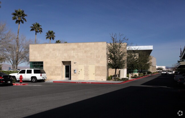
Property Record
395 E Sunset Rd, Las Vegas, NV 89119


Save to a Folder
{{folder.Name}}
{{folder.ListingIds.length}} Properties
{{folder.ListingIds.length}} Property
Create a New Folder
Property Detail
395 E Sunset Rd
177-04-510-003
HUGHES AIRPORT CENTER PHASE 3 UNIT #2 PLAT BOOK 46 PAGE 23 LOT 1
Commercialnec
Clark
MD
Nevada
B and X Area of moderate flood hazard, usually the area between the limits of the 100-year and 500-year floods.
1
2026
1.68 AC
2026
South Las Vegas
002847
Las Vegas
17,325 SF
Las Vegas-Henderson-North Las Vegas, NV
NEARBY LISTINGS FOR SALE OR LEASE
DEMOGRAPHICS near 395 E Sunset Rd
1 mile
3 mile
5 mile
2025 Total Population
608
73,651
373,189
2030 Population
624
77,449
392,056
Pop Growth 2025-2030
+ 2.63%
+ 5.16%
+ 5.06%
Average Age
38
42
41
2025 Total Households
275
32,221
156,983
HH Growth 2025-2030
+ 2.55%
+ 5.52%
+ 5.15%
Median Household Inc
$55,465
$67,455
$67,810
Avg Household Size
2.20
2.20
2.30
2025 Avg HH Vehicles
1.00
2.00
2.00
Median Home Value
$351,785
$449,716
$433,982
Median Year Built
1987
1992
1992
Nearby Places
Map Layers
Map Styles
 Street
 Aerial
Layers
 Traffic
 Biking
Places
Listings with unknown addresses are not visible on the map
- Restaurants
- Banks
- Shops
- Fitness
- Groceries
PUBLIC TRANSPORTATION
AIRPORT
Harry Reid International
Drive
Walk
Distance
Harry Reid International
7 min
3.9 mi
Boulder City Municipal
Drive
Walk
Distance
Boulder City Municipal
32 min
22.9 mi
Freight Ports
Port of Long Beach
Drive
Walk
Distance
Port of Long Beach
311 min
277.6 mi
Nearby Properties
Address
Land Use
TOTAL SIZE
Lot Size
Zoning
Address
Land Use
TOTAL SIZE
Lot Size
Zoning
2,000,377 SF
118.89 AC
Address
Land Use
TOTAL SIZE
Lot Size
Zoning
1,546,466 SF
61.43 AC
H1
Address
Land Use
TOTAL SIZE
Lot Size
Zoning
2,828,726 SF
101.88 AC
Address
Land Use
TOTAL SIZE
Lot Size
Zoning
937,376 SF
59.19 AC
Address
Land Use
TOTAL SIZE
Lot Size
Zoning
1,166,098 SF
57.58 AC
Address
Land Use
TOTAL SIZE
Lot Size
Zoning
763,204 SF
10.47 AC
H1
Address
Land Use
TOTAL SIZE
Lot Size
Zoning
225,512 SF
50.14 AC
Address
Land Use
TOTAL SIZE
Lot Size
Zoning
112,160 SF
20.60 AC
Address
Land Use
TOTAL SIZE
Lot Size
Zoning
742,547 SF
19.87 AC
H1
Address
Land Use
TOTAL SIZE
Lot Size
Zoning
1,911,901 SF
1.24 AC
Address
Land Use
TOTAL SIZE
Lot Size
Zoning
79.03 AC
PF
Address
Land Use
TOTAL SIZE
Lot Size
Zoning
3,200 SF
16.74 AC
Address
Land Use
TOTAL SIZE
Lot Size
Zoning
1,744,547 SF
8.25 AC
Address
Land Use
TOTAL SIZE
Lot Size
Zoning
764,918 SF
94.41 AC
H1
Address
Land Use
TOTAL SIZE
Lot Size
Zoning
323,696 SF
24.62 AC
H1
Address
Land Use
TOTAL SIZE
Lot Size
Zoning
76.93 AC
PF
Address
Land Use
TOTAL SIZE
Lot Size
Zoning
566,218 SF
12.98 AC
Address
Land Use
TOTAL SIZE
Lot Size
Zoning
278,297 SF
35.11 AC
Address
Land Use
TOTAL SIZE
Lot Size
Zoning
945,212 SF
0.60 AC
Address
Land Use
TOTAL SIZE
Lot Size
Zoning
138.07 AC
PF
Address
Land Use
TOTAL SIZE
Lot Size
Zoning
17,406 SF
9.46 AC
Address
Land Use
TOTAL SIZE
Lot Size
Zoning
611,977 SF
6.82 AC
Address
Land Use
TOTAL SIZE
Lot Size
Zoning
94,198 SF
34.53 AC
H1
Address
Land Use
TOTAL SIZE
Lot Size
Zoning
32,655 SF
2.40 AC
Address
Land Use
TOTAL SIZE
Lot Size
Zoning
321,990 SF
76.15 AC
PF
Address
Land Use
TOTAL SIZE
Lot Size
Zoning
391,021 SF
40.14 AC
Address
Land Use
TOTAL SIZE
Lot Size
Zoning
56.95 AC
PF
Address
Land Use
TOTAL SIZE
Lot Size
Zoning
13.26 AC
Address
Land Use
TOTAL SIZE
Lot Size
Zoning
459,983 SF
12.65 AC
M1
The World's #1 Commercial Real Estate Marketplace
Connect with us
© 2026 CoStar Group
The information above has been obtained from sources believed reliable. While we do not doubt its accuracy we have not verified it and make no guarantee, warranty or representation about it. It is your responsibility to independently confirm its accuracy and completeness. Any projections, opinions, assumptions, or estimates used are for example only and do not represent the current or future performance of the property. The value of this transaction to you depends on tax and other factors which should be evaluated by your tax, financial, and legal advisors. You and your advisors should conduct a careful, independent investigation of the property to determine to your satisfaction the suitability of the property for your needs.