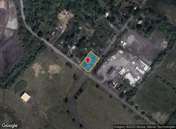
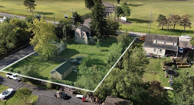
Property Record
395 Evergreen Rd, Pottstown, PA 19464
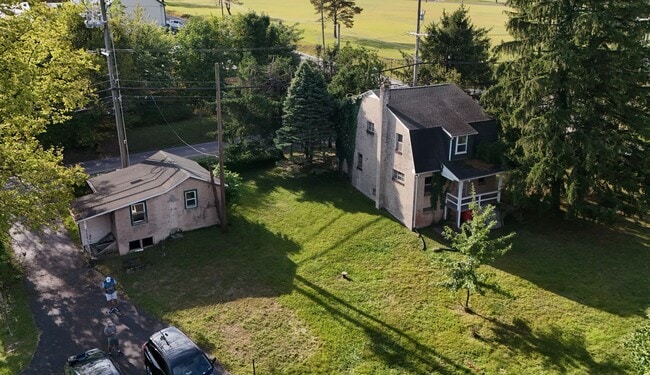
This Property Is For Sale
NEARBY LISTINGS FOR SALE OR LEASE
Property Detail
395 Evergreen Rd
Philadelphia-Camden-Wilmington, PA-NJ-DE-MD
Montgomery
42-00-04984-005
Pennsylvania
Sfr
0.62 AC
X
West Montgomery County
42029C0020G
Philadelphia
1,496 SF
DEMOGRAPHICS near 395 Evergreen Rd
1 Mile
3 Mile
5 Mile
2024 Total Population
1,746
37,409
105,083
2029 Population
1,851
38,462
107,571
Pop Growth 2024-2029
+ 6.01%
+ 2.81%
+ 2.37%
Average Age
46
41
41
2024 Total Households
649
14,345
40,582
HH Growth 2024-2029
+ 6.63%
+ 2.89%
+ 2.39%
Median Household Inc
$78,713
$94,405
$92,447
Avg Household Size
2.40
2.50
2.50
2024 Avg HH Vehicles
2.00
2.00
2.00
Median Home Value
$312,879
$344,209
$349,382
Median Year Built
1991
1983
1975
Nearby Places
Map Layers
Map Styles
 Street
 Aerial
- Restaurants
- Banks
- Shops
- Fitness
- Groceries
PUBLIC TRANSPORTATION
AIRPORT
Lehigh Valley International
DRIVE
WALK
Distance
Lehigh Valley International
69 min
37.1 mi
Philadelphia International
DRIVE
WALK
Distance
Philadelphia International
65 min
43.6 mi
Freight Ports
South Jersey Port
DRIVE
WALK
Distance
South Jersey Port
60 min
39.7 mi
Nearby Properties
Address
Land Use
TOTAL SIZE
Lot Size
Zoning
Address
Land Use
TOTAL SIZE
Lot Size
Zoning
605,161 SF
78.08 AC
LLI
Address
Land Use
TOTAL SIZE
Lot Size
Zoning
707,965 SF
80.33 AC
RMHD
Address
Land Use
TOTAL SIZE
Lot Size
Zoning
327,827 SF
21 AC
RMD
Address
Land Use
TOTAL SIZE
Lot Size
Zoning
1,298,806 SF
305.46 AC
HI
Address
Land Use
TOTAL SIZE
Lot Size
Zoning
309,443 SF
20.56 AC
GE
Address
Land Use
TOTAL SIZE
Lot Size
Zoning
268,366 SF
32.55 AC
R4
Address
Land Use
TOTAL SIZE
Lot Size
Zoning
316,623 SF
15.26 AC
R4
Address
Land Use
TOTAL SIZE
Lot Size
Zoning
191,272 SF
48.22 AC
R2
Address
Land Use
TOTAL SIZE
Lot Size
Zoning
240,140 SF
31.50 AC
R3
Address
Land Use
TOTAL SIZE
Lot Size
Zoning
123,946 SF
39.60 AC
R2
Address
Land Use
TOTAL SIZE
Lot Size
Zoning
97,188 SF
13.13 AC
OLI
Address
Land Use
TOTAL SIZE
Lot Size
Zoning
147,444 SF
16.09 AC
LLI
Address
Land Use
TOTAL SIZE
Lot Size
Zoning
84,953 SF
51.29 AC
R2
Address
Land Use
TOTAL SIZE
Lot Size
Zoning
94,997 SF
6 AC
R3
Address
Land Use
TOTAL SIZE
Lot Size
Zoning
214,914 SF
48.17 AC
OLI
Address
Land Use
TOTAL SIZE
Lot Size
Zoning
222,272 SF
21.60 AC
OLI
Address
Land Use
TOTAL SIZE
Lot Size
Zoning
681,836 SF
40.12 AC
HI
Address
Land Use
TOTAL SIZE
Lot Size
Zoning
74,270 SF
7.25 AC
MS
Address
Land Use
TOTAL SIZE
Lot Size
Zoning
245,651 SF
20.79 AC
R2
Address
Land Use
TOTAL SIZE
Lot Size
Zoning
68,775 SF
14.91 AC
OLI
Address
Land Use
TOTAL SIZE
Lot Size
Zoning
73,584 SF
0.74 AC
LI
Address
Land Use
TOTAL SIZE
Lot Size
Zoning
73,584 SF
0.64 AC
LI
Address
Land Use
TOTAL SIZE
Lot Size
Zoning
73,584 SF
0.72 AC
LI
Address
Land Use
TOTAL SIZE
Lot Size
Zoning
73,584 SF
0.68 AC
LI
Address
Land Use
TOTAL SIZE
Lot Size
Zoning
0.70 AC
LI
Address
Land Use
TOTAL SIZE
Lot Size
Zoning
86,532 SF
13 AC
R3
Address
Land Use
TOTAL SIZE
Lot Size
Zoning
70,315 SF
15.64 AC
R4
Address
Land Use
TOTAL SIZE
Lot Size
Zoning
70,319 SF
7.31 AC
CO
Address
Land Use
TOTAL SIZE
Lot Size
Zoning
39,310 SF
4.63 AC
OLI
Address
Land Use
TOTAL SIZE
Lot Size
Zoning
73,443 SF
13.14 AC
R2
The World's #1 Commercial Real Estate Marketplace
Connect with us
© 2025 CoStar Group
The information above has been obtained from sources believed reliable. While we do not doubt its accuracy we have not verified it and make no guarantee, warranty or representation about it. It is your responsibility to independently confirm its accuracy and completeness. Any projections, opinions, assumptions, or estimates used are for example only and do not represent the current or future performance of the property. The value of this transaction to you depends on tax and other factors which should be evaluated by your tax, financial, and legal advisors. You and your advisors should conduct a careful, independent investigation of the property to determine to your satisfaction the suitability of the property for your needs.