Property Record
395 Maple St, Brooklyn, NY 11225
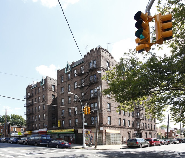

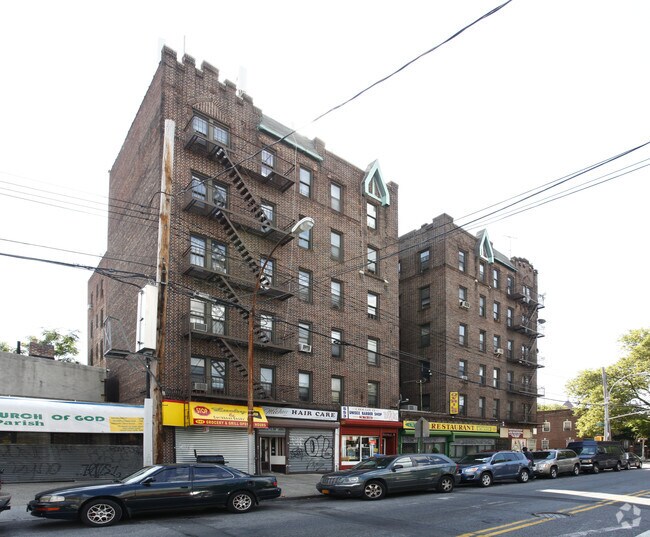

Property Detail
395 Maple St
04792-0051
DOCID-2012122000293002
Apartment
Kings
R6
New York
B and X Area of moderate flood hazard, usually the area between the limits of the 100-year and 500-year floods.
51
2024
0.23 AC
2025
East Flatbush
080600
Long Island (New York)
45,383 SF
New York-Jersey City-White Plains, NY-NJ
NEARBY LISTINGS FOR SALE OR LEASE
DEMOGRAPHICS near 395 Maple St
1 mile
3 mile
5 mile
2025 Total Population
192,110
1,343,408
2,724,022
2030 Population
192,927
1,334,762
2,697,712
Pop Growth 2025-2030
+ 0.43%
(0.64%)
(0.97%)
Average Age
40
38
39
2025 Total Households
73,715
491,993
1,006,162
HH Growth 2025-2030
+ 0.16%
(0.95%)
(0.94%)
Median Household Inc
$78,967
$80,887
$80,689
Avg Household Size
2.50
2.60
2.60
2025 Avg HH Vehicles
.00
.00
1.00
Median Home Value
$959,236
$919,495
$910,659
Median Year Built
1947
1948
1948
Nearby Places
Map Layers
Map Styles
 Street
 Aerial
Transit
 Traffic
 Biking
Places
Listings with unknown addresses are not visible on the map
- Restaurants
- Banks
- Shops
- Fitness
- Groceries
PUBLIC TRANSPORTATION
COMMUTER RAIL
Nostrand Avenue Station (Far Rockaway Branch - Long Island Rail Road, Hempstead Branch - Long Island Rail Road, Long Beach Branch - Long Island Rail Road, West Hempstead Branch - Long Island Rail Road)
Drive
Walk
Distance
Nostrand Avenue Station (Far Rockaway Branch - Long Island Rail Road, Hempstead Branch - Long Island Rail Road, Long Beach Branch - Long Island Rail Road, West Hempstead Branch - Long Island Rail Road)
7 min
1.8 mi
Drive
Walk
Distance
7 min
2.6 mi
AIRPORT
John F Kennedy International
Drive
Walk
Distance
John F Kennedy International
22 min
11.0 mi
LaGuardia
Drive
Walk
Distance
LaGuardia
25 min
11.7 mi
Newark Liberty International
Drive
Walk
Distance
Newark Liberty International
34 min
17.6 mi
Freight Ports
NY - Red Hook Container Terminal
Drive
Walk
Distance
NY - Red Hook Container Terminal
12 min
5.0 mi
The World's #1 Commercial Real Estate Marketplace
Connect with us
© 2026 CoStar Group
The information above has been obtained from sources believed reliable. While we do not doubt its accuracy we have not verified it and make no guarantee, warranty or representation about it. It is your responsibility to independently confirm its accuracy and completeness. Any projections, opinions, assumptions, or estimates used are for example only and do not represent the current or future performance of the property. The value of this transaction to you depends on tax and other factors which should be evaluated by your tax, financial, and legal advisors. You and your advisors should conduct a careful, independent investigation of the property to determine to your satisfaction the suitability of the property for your needs.