Property Record
395 Roberts Rd, Campbellsville, KY 42718
NEARBY LISTINGS FOR SALE OR LEASE
Property Detail
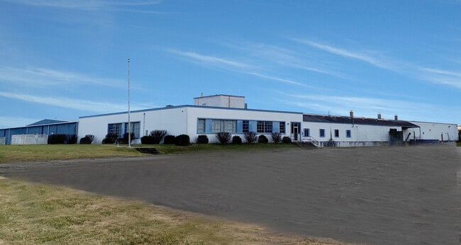
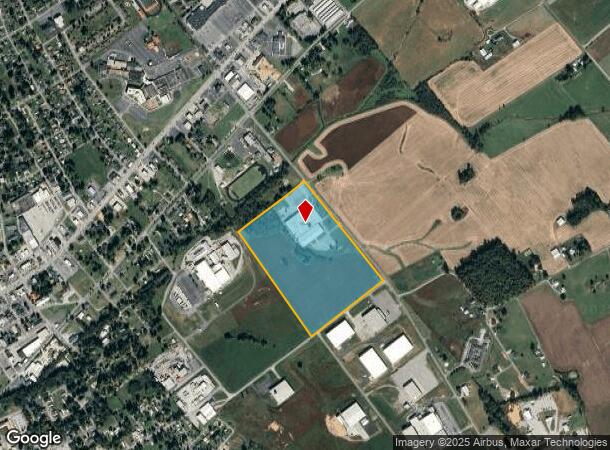
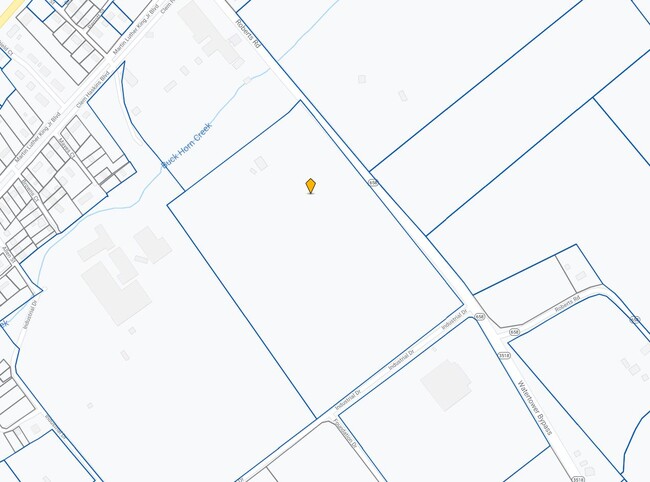
395 Roberts Rd
44-001
WAREHOUSE & 40 ACRES
Industrialgeneral
Taylor
X
Kentucky
21217C0155C
40 AC
2025
Kentucky East Area
2025
Other Market Areas
920502
Campbellsville, KY
DEMOGRAPHICS near 395 Roberts Rd
1 Mile
3 Mile
5 Mile
2024 Total Population
4,713
14,981
19,832
2029 Population
4,857
15,319
20,298
Pop Growth 2024-2029
+ 3.06%
+ 2.26%
+ 2.35%
Average Age
40
39
40
2024 Total Households
1,956
5,858
7,758
HH Growth 2024-2029
+ 3.17%
+ 2.30%
+ 2.38%
Median Household Inc
$33,263
$53,221
$56,415
Avg Household Size
2.20
2.30
2.30
2024 Avg HH Vehicles
2.00
2.00
2.00
Median Home Value
$131,677
$145,715
$148,366
Median Year Built
1972
1974
1976
Nearby Places
Map Layers
Map Styles
 Street
 Aerial
- Restaurants
- Banks
- Shops
- Fitness
- Groceries
SALE & LEASE HISTORY
LISTING DATE
SALE/LEASE

Jun 17, 2020
For Sale
Nearby Properties
Address
Land Use
TOTAL SIZE
Lot Size
Zoning
Address
Land Use
TOTAL SIZE
Lot Size
Zoning
769,876 SF
72.89 AC
Address
Land Use
TOTAL SIZE
Lot Size
Zoning
104.31 AC
Address
Land Use
TOTAL SIZE
Lot Size
Zoning
142,000 SF
10.31 AC
Address
Land Use
TOTAL SIZE
Lot Size
Zoning
53,100 SF
20 AC
Address
Land Use
TOTAL SIZE
Lot Size
Zoning
181,074 SF
20.59 AC
Address
Land Use
TOTAL SIZE
Lot Size
Zoning
3,526 SF
1.71 AC
Address
Land Use
TOTAL SIZE
Lot Size
Zoning
121,198 SF
20.41 AC
Address
Land Use
TOTAL SIZE
Lot Size
Zoning
114,361 SF
17.16 AC
Address
Land Use
TOTAL SIZE
Lot Size
Zoning
46,509 SF
3 AC
Address
Land Use
TOTAL SIZE
Lot Size
Zoning
27,484 SF
8.62 AC
Address
Land Use
TOTAL SIZE
Lot Size
Zoning
97,164 SF
53.19 AC
Address
Land Use
TOTAL SIZE
Lot Size
Zoning
68,200 SF
7.76 AC
Address
Land Use
TOTAL SIZE
Lot Size
Zoning
7,069 SF
1.50 AC
Address
Land Use
TOTAL SIZE
Lot Size
Zoning
37,112 SF
29.45 AC
Address
Land Use
TOTAL SIZE
Lot Size
Zoning
2,400 SF
4.24 AC
Address
Land Use
TOTAL SIZE
Lot Size
Zoning
2,880 SF
1.09 AC
Address
Land Use
TOTAL SIZE
Lot Size
Zoning
5,049 SF
119.75 AC
Address
Land Use
TOTAL SIZE
Lot Size
Zoning
24,000 SF
2.20 AC
Address
Land Use
TOTAL SIZE
Lot Size
Zoning
Address
Land Use
TOTAL SIZE
Lot Size
Zoning
48,000 SF
20 AC
Address
Land Use
TOTAL SIZE
Lot Size
Zoning
10,036 SF
1.99 AC
Address
Land Use
TOTAL SIZE
Lot Size
Zoning
99,498 SF
9.25 AC
Address
Land Use
TOTAL SIZE
Lot Size
Zoning
57,290 SF
10.53 AC
Address
Land Use
TOTAL SIZE
Lot Size
Zoning
26,900 SF
10 AC
Address
Land Use
TOTAL SIZE
Lot Size
Zoning
36,872 SF
4.81 AC
Address
Land Use
TOTAL SIZE
Lot Size
Zoning
18,492 SF
2.71 AC
Address
Land Use
TOTAL SIZE
Lot Size
Zoning
21,540 SF
2 AC
Address
Land Use
TOTAL SIZE
Lot Size
Zoning
6,500 SF
1.61 AC
Address
Land Use
TOTAL SIZE
Lot Size
Zoning
12,150 SF
4.40 AC
Address
Land Use
TOTAL SIZE
Lot Size
Zoning
48,000 SF
15.56 AC
The World's #1 Commercial Real Estate Marketplace
Connect with us
© 2026 CoStar Group
The information above has been obtained from sources believed reliable. While we do not doubt its accuracy we have not verified it and make no guarantee, warranty or representation about it. It is your responsibility to independently confirm its accuracy and completeness. Any projections, opinions, assumptions, or estimates used are for example only and do not represent the current or future performance of the property. The value of this transaction to you depends on tax and other factors which should be evaluated by your tax, financial, and legal advisors. You and your advisors should conduct a careful, independent investigation of the property to determine to your satisfaction the suitability of the property for your needs.