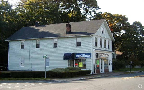
Property Record
395 S Maple Ave, Glen Rock, NJ 07452

NEARBY LISTINGS FOR SALE OR LEASE
Property Detail
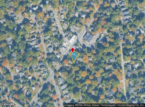
395 S Maple Ave
22-00007-0000-00023
50 X 100
Commercialnec
Bergen
X
New Jersey
34003C0176H
23
2024
0.12 AC
2025
Route 208 Corridor
022100
Northern New Jersey
2,548 SF
New York-Jersey City-White Plains, NY-NJ
DEMOGRAPHICS near 395 S Maple Ave
1 mile
3 mile
5 mile
2024 Total Population
15,834
120,484
374,350
2029 Population
15,801
118,688
366,902
Pop Growth 2024-2029
(0.21%)
(1.49%)
(1.99%)
Average Age
40
41
40
2024 Total Households
5,418
41,503
125,459
HH Growth 2024-2029
(0.22%)
(1.68%)
(2.06%)
Median Household Inc
$166,974
$138,051
$97,106
Avg Household Size
2.90
2.80
2.90
2024 Avg HH Vehicles
2.00
2.00
2.00
Median Home Value
$759,830
$671,589
$609,093
Median Year Built
1950
1954
1955
Nearby Places
Map Layers
Map Styles
 Street
 Aerial
Transit
 Traffic
 Biking
Places
Listings with unknown addresses are not visible on the map
- Restaurants
- Banks
- Shops
- Fitness
- Groceries
PUBLIC TRANSPORTATION
TRANSIT/SUBWAY
Glen Rock Boro Hall (Bergen County/Port Jervis Line - NJ Transit Commuter Rail (NJ Transit))
Drive
Walk
Distance
Glen Rock Boro Hall (Bergen County/Port Jervis Line - NJ Transit Commuter Rail (NJ Transit))
3 min
16 min
0.8 mi
Ridgewood (Bergen County/Port Jervis Line - NJ Transit Commuter Rail (NJ Transit), Main/Port Jervis Line - NJ Transit Commuter Rail (NJ Transit))
Drive
Walk
Distance
Ridgewood (Bergen County/Port Jervis Line - NJ Transit Commuter Rail (NJ Transit), Main/Port Jervis Line - NJ Transit Commuter Rail (NJ Transit))
4 min
18 min
0.9 mi
Glen Rock Main Line (Main/Port Jervis Line - NJ Transit Commuter Rail (NJ Transit))
Drive
Walk
Distance
Glen Rock Main Line (Main/Port Jervis Line - NJ Transit Commuter Rail (NJ Transit))
3 min
19 min
1.0 mi
COMMUTER RAIL
Glen Rock Boro Hall (Bergen County/Port Jervis Line - NJ Transit Commuter Rail (NJ Transit))
Drive
Walk
Distance
Glen Rock Boro Hall (Bergen County/Port Jervis Line - NJ Transit Commuter Rail (NJ Transit))
3 min
16 min
0.8 mi
Ridgewood (Bergen County/Port Jervis Line - NJ Transit Commuter Rail (NJ Transit), Main/Port Jervis Line - NJ Transit Commuter Rail (NJ Transit))
Drive
Walk
Distance
Ridgewood (Bergen County/Port Jervis Line - NJ Transit Commuter Rail (NJ Transit), Main/Port Jervis Line - NJ Transit Commuter Rail (NJ Transit))
3 min
18 min
0.9 mi
AIRPORT
LaGuardia
Drive
Walk
Distance
LaGuardia
41 min
23.7 mi
Newark Liberty International
Drive
Walk
Distance
Newark Liberty International
35 min
24.1 mi
Westchester County
Drive
Walk
Distance
Westchester County
56 min
37.2 mi
Freight Ports
Maher Terminal
Drive
Walk
Distance
Maher Terminal
42 min
25.1 mi
Nearby Properties
Address
Land Use
TOTAL SIZE
Lot Size
Zoning
Address
Land Use
TOTAL SIZE
Lot Size
Zoning
45,191 SF
3.11 AC
BL
Address
Land Use
TOTAL SIZE
Lot Size
Zoning
466,866 SF
154.93 AC
R150
Address
Land Use
TOTAL SIZE
Lot Size
Zoning
15.57 AC
H
Address
Land Use
TOTAL SIZE
Lot Size
Zoning
7,060 SF
115.84 AC
HP
Address
Land Use
TOTAL SIZE
Lot Size
Zoning
394,039 SF
24.31 AC
BG
Address
Land Use
TOTAL SIZE
Lot Size
Zoning
164,588 SF
14.60 AC
BG
Address
Land Use
TOTAL SIZE
Lot Size
Zoning
61.98 AC
Address
Land Use
TOTAL SIZE
Lot Size
Zoning
12,268 SF
98 AC
CR
Address
Land Use
TOTAL SIZE
Lot Size
Zoning
9.96 AC
MU
Address
Land Use
TOTAL SIZE
Lot Size
Zoning
205,856 SF
12.49 AC
BIL
Address
Land Use
TOTAL SIZE
Lot Size
Zoning
205,856 SF
12.12 AC
BIL
Address
Land Use
TOTAL SIZE
Lot Size
Zoning
21.48 AC
Address
Land Use
TOTAL SIZE
Lot Size
Zoning
156,877 SF
12.60 AC
BG
Address
Land Use
TOTAL SIZE
Lot Size
Zoning
57,680 SF
20.01 AC
CR
Address
Land Use
TOTAL SIZE
Lot Size
Zoning
29,018 SF
4.40 AC
BG
Address
Land Use
TOTAL SIZE
Lot Size
Zoning
33,222 SF
243.85 AC
RGC
Address
Land Use
TOTAL SIZE
Lot Size
Zoning
45,269 SF
5.66 AC
BG
Address
Land Use
TOTAL SIZE
Lot Size
Zoning
127,333 SF
8.30 AC
R100
Address
Land Use
TOTAL SIZE
Lot Size
Zoning
161,352 SF
14.02 AC
BG
Address
Land Use
TOTAL SIZE
Lot Size
Zoning
192,486 SF
11.82 AC
BL
Address
Land Use
TOTAL SIZE
Lot Size
Zoning
Address
Land Use
TOTAL SIZE
Lot Size
Zoning
92,778 SF
8.86 AC
BIL
Address
Land Use
TOTAL SIZE
Lot Size
Zoning
824,024 SF
39.71 AC
I1
Address
Land Use
TOTAL SIZE
Lot Size
Zoning
20.30 AC
Address
Land Use
TOTAL SIZE
Lot Size
Zoning
90.48 AC
Address
Land Use
TOTAL SIZE
Lot Size
Zoning
144,868 SF
11.14 AC
BG
Address
Land Use
TOTAL SIZE
Lot Size
Zoning
157,100 SF
11.84 AC
BG
Address
Land Use
TOTAL SIZE
Lot Size
Zoning
210,907 SF
10 AC
R100
Address
Land Use
TOTAL SIZE
Lot Size
Zoning
Address
Land Use
TOTAL SIZE
Lot Size
Zoning
94,076 SF
7.57 AC
BIL
The World's #1 Commercial Real Estate Marketplace
Connect with us
© 2026 CoStar Group
The information above has been obtained from sources believed reliable. While we do not doubt its accuracy we have not verified it and make no guarantee, warranty or representation about it. It is your responsibility to independently confirm its accuracy and completeness. Any projections, opinions, assumptions, or estimates used are for example only and do not represent the current or future performance of the property. The value of this transaction to you depends on tax and other factors which should be evaluated by your tax, financial, and legal advisors. You and your advisors should conduct a careful, independent investigation of the property to determine to your satisfaction the suitability of the property for your needs.