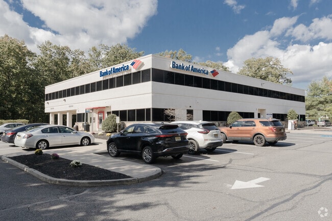
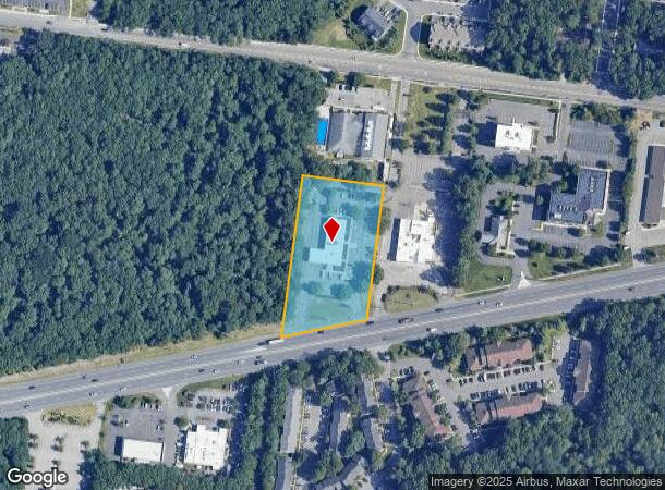
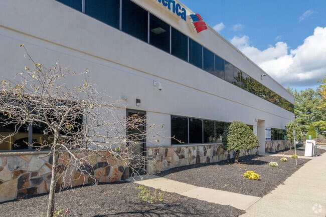
Property Record
395 Route 70, Lakewood, NJ 08701
Current Lease Availabilities
NEARBY LISTINGS FOR SALE OR LEASE
Property Detail
395 Route 70
Lakewood-New Brunswick, NJ
Bricksburg Land & Improv
15-01087-0000-00030
222X391 BANK OF AMERICA
Commercialnec
Ocean
X
New Jersey
34029C0187F
30
2024
1.99 AC
2025
Ocean County
715800
Northern New Jersey
14,229 SF
DEMOGRAPHICS near 395 Route 70
1 Mile
3 Mile
5 Mile
2024 Total Population
12,377
89,946
214,440
2029 Population
13,030
93,801
223,442
Pop Growth 2024-2029
+ 5.28%
+ 4.29%
+ 4.20%
Average Age
31
33
34
2024 Total Households
3,639
25,946
64,393
HH Growth 2024-2029
+ 4.34%
+ 3.66%
+ 3.63%
Median Household Inc
$55,131
$56,739
$65,202
Avg Household Size
3.10
3.10
3.00
2024 Avg HH Vehicles
1.00
2.00
2.00
Median Home Value
$206,015
$312,060
$328,466
Median Year Built
1990
1991
1984
Nearby Places
Map Layers
Map Styles
 Street
 Aerial
- Restaurants
- Banks
- Shops
- Fitness
- Groceries
PUBLIC TRANSPORTATION
COMMUTER RAIL
Bay Head (North Jersey Coast Line - NJ Transit Commuter Rail (NJ Transit))
DRIVE
WALK
Distance
Bay Head (North Jersey Coast Line - NJ Transit Commuter Rail (NJ Transit))
18 min
9.6 mi
Freight Ports
New York Container Terminal
DRIVE
WALK
Distance
New York Container Terminal
68 min
49.1 mi
Nearby Properties
Address
Land Use
TOTAL SIZE
Lot Size
Zoning
Address
Land Use
TOTAL SIZE
Lot Size
Zoning
12.43 AC
HD7
Address
Land Use
TOTAL SIZE
Lot Size
Zoning
338.52 AC
OSP
Address
Land Use
TOTAL SIZE
Lot Size
Zoning
56.58 AC
DA-1
Address
Land Use
TOTAL SIZE
Lot Size
Zoning
29.34 AC
B4
Address
Land Use
TOTAL SIZE
Lot Size
Zoning
23,843 SF
37.83 AC
B5
Address
Land Use
TOTAL SIZE
Lot Size
Zoning
38.98 AC
R20C
Address
Land Use
TOTAL SIZE
Lot Size
Zoning
272,500 SF
17.88 AC
M1
Address
Land Use
TOTAL SIZE
Lot Size
Zoning
23,391 SF
19.32 AC
RM
Address
Land Use
TOTAL SIZE
Lot Size
Zoning
1.80 AC
B5
Address
Land Use
TOTAL SIZE
Lot Size
Zoning
22.34 AC
ABC
Address
Land Use
TOTAL SIZE
Lot Size
Zoning
50,125 SF
19.18 AC
M1
Address
Land Use
TOTAL SIZE
Lot Size
Zoning
12,269 SF
14.92 AC
R40C
Address
Land Use
TOTAL SIZE
Lot Size
Zoning
5,826 SF
15.35 AC
RM
Address
Land Use
TOTAL SIZE
Lot Size
Zoning
97,092 SF
15.97 AC
RHB
Address
Land Use
TOTAL SIZE
Lot Size
Zoning
15.17 AC
M1
Address
Land Use
TOTAL SIZE
Lot Size
Zoning
94,380 SF
8.71 AC
B4
Address
Land Use
TOTAL SIZE
Lot Size
Zoning
39,777 SF
3.50 AC
M1
Address
Land Use
TOTAL SIZE
Lot Size
Zoning
85,995 SF
7.60 AC
M1
Address
Land Use
TOTAL SIZE
Lot Size
Zoning
39.28 AC
R12
Address
Land Use
TOTAL SIZE
Lot Size
Zoning
93,712 SF
15.17 AC
M1
Address
Land Use
TOTAL SIZE
Lot Size
Zoning
52.07 AC
RR2
Address
Land Use
TOTAL SIZE
Lot Size
Zoning
5,290 SF
12.95 AC
LP
Address
Land Use
TOTAL SIZE
Lot Size
Zoning
19.11 AC
M1
Address
Land Use
TOTAL SIZE
Lot Size
Zoning
38,920 SF
9.70 AC
M1
Address
Land Use
TOTAL SIZE
Lot Size
Zoning
148,718 SF
15.74 AC
RUR
Address
Land Use
TOTAL SIZE
Lot Size
Zoning
170,849 SF
12.89 AC
M1
Address
Land Use
TOTAL SIZE
Lot Size
Zoning
152.17 AC
ABC
Address
Land Use
TOTAL SIZE
Lot Size
Zoning
9.01 AC
M10A
Address
Land Use
TOTAL SIZE
Lot Size
Zoning
5,171 SF
4.34 AC
R20
Address
Land Use
TOTAL SIZE
Lot Size
Zoning
96,503 SF
2.26 AC
R-OP
The World's #1 Commercial Real Estate Marketplace
Connect with us
© 2026 CoStar Group
The information above has been obtained from sources believed reliable. While we do not doubt its accuracy we have not verified it and make no guarantee, warranty or representation about it. It is your responsibility to independently confirm its accuracy and completeness. Any projections, opinions, assumptions, or estimates used are for example only and do not represent the current or future performance of the property. The value of this transaction to you depends on tax and other factors which should be evaluated by your tax, financial, and legal advisors. You and your advisors should conduct a careful, independent investigation of the property to determine to your satisfaction the suitability of the property for your needs.