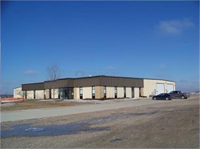
Property Record
3950 5Th Ave N, Estherville, IA 51334


NEARBY LISTINGS FOR SALE OR LEASE
-
-
View all Estherville listings for sale on LoopNet.com
Property Detail
3950 5Th Ave N
Lightindustrial
PT SE NW 12 99 34
X
Emmet
19063C0166C
Iowa
2025
2.42 AC
2025
Other Market Areas
070300
0512100016
16,200 SF
DEMOGRAPHICS near 3950 5Th Ave N
1 Mile
3 Mile
5 Mile
2024 Total Population
1,412
6,238
6,482
2029 Population
1,379
6,080
6,311
Pop Growth 2024-2029
(2.34%)
(2.53%)
(2.64%)
Average Age
42
41
41
2024 Total Households
594
2,582
2,687
HH Growth 2024-2029
(2.53%)
(2.67%)
(2.79%)
Median Household Inc
$49,249
$54,971
$55,752
Avg Household Size
2.10
2.20
2.20
2024 Avg HH Vehicles
2.00
2.00
2.00
Median Home Value
$82,183
$92,767
$94,194
Median Year Built
1957
1958
1957
Nearby Places
Map Layers
Map Styles
 Street
 Aerial
- Restaurants
- Banks
- Shops
- Fitness
- Groceries
SALE & LEASE HISTORY
LISTING DATE
SALE/LEASE

Sep 25, 2016
For Lease
Nov 17, 2016
For Sale
Nearby Properties
Address
Land Use
TOTAL SIZE
Lot Size
Zoning
Address
Land Use
TOTAL SIZE
Lot Size
Zoning
4,600 SF
23.30 AC
Address
Land Use
TOTAL SIZE
Lot Size
Zoning
105,796 SF
1.50 AC
Address
Land Use
TOTAL SIZE
Lot Size
Zoning
2,000 SF
13.33 AC
Address
Land Use
TOTAL SIZE
Lot Size
Zoning
55,776 SF
4.70 AC
Address
Land Use
TOTAL SIZE
Lot Size
Zoning
1,196 SF
3.11 AC
Address
Land Use
TOTAL SIZE
Lot Size
Zoning
58,023 SF
2.13 AC
Address
Land Use
TOTAL SIZE
Lot Size
Zoning
1,104 SF
20.24 AC
Address
Land Use
TOTAL SIZE
Lot Size
Zoning
37.02 AC
Address
Land Use
TOTAL SIZE
Lot Size
Zoning
7,192 SF
15.59 AC
Address
Land Use
TOTAL SIZE
Lot Size
Zoning
191,964 SF
5.93 AC
Address
Land Use
TOTAL SIZE
Lot Size
Zoning
20,947 SF
3.38 AC
Address
Land Use
TOTAL SIZE
Lot Size
Zoning
10,500 SF
4.71 AC
Address
Land Use
TOTAL SIZE
Lot Size
Zoning
3.91 AC
Address
Land Use
TOTAL SIZE
Lot Size
Zoning
9,152 SF
1.70 AC
Address
Land Use
TOTAL SIZE
Lot Size
Zoning
58,023 SF
2.13 AC
Address
Land Use
TOTAL SIZE
Lot Size
Zoning
21,360 SF
4.71 AC
Address
Land Use
TOTAL SIZE
Lot Size
Zoning
21,916 SF
12 AC
Address
Land Use
TOTAL SIZE
Lot Size
Zoning
32,824 SF
4.60 AC
Address
Land Use
TOTAL SIZE
Lot Size
Zoning
35,592 SF
3.65 AC
Address
Land Use
TOTAL SIZE
Lot Size
Zoning
73,717 SF
2.73 AC
Address
Land Use
TOTAL SIZE
Lot Size
Zoning
1,152 SF
4.50 AC
Address
Land Use
TOTAL SIZE
Lot Size
Zoning
22,098 SF
0.20 AC
Address
Land Use
TOTAL SIZE
Lot Size
Zoning
10,295 SF
4.80 AC
Address
Land Use
TOTAL SIZE
Lot Size
Zoning
52,228 SF
1.85 AC
Address
Land Use
TOTAL SIZE
Lot Size
Zoning
51,000 SF
4.69 AC
Address
Land Use
TOTAL SIZE
Lot Size
Zoning
12,156 SF
1.20 AC
Address
Land Use
TOTAL SIZE
Lot Size
Zoning
31,320 SF
2.48 AC
Address
Land Use
TOTAL SIZE
Lot Size
Zoning
33,010 SF
2.67 AC
Address
Land Use
TOTAL SIZE
Lot Size
Zoning
10,920 SF
1.60 AC
Address
Land Use
TOTAL SIZE
Lot Size
Zoning
20,688 SF
3 AC
The World's #1 Commercial Real Estate Marketplace
Connect with us
© 2026 CoStar Group
The information above has been obtained from sources believed reliable. While we do not doubt its accuracy we have not verified it and make no guarantee, warranty or representation about it. It is your responsibility to independently confirm its accuracy and completeness. Any projections, opinions, assumptions, or estimates used are for example only and do not represent the current or future performance of the property. The value of this transaction to you depends on tax and other factors which should be evaluated by your tax, financial, and legal advisors. You and your advisors should conduct a careful, independent investigation of the property to determine to your satisfaction the suitability of the property for your needs.