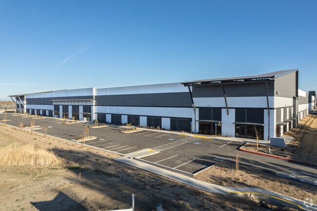
Property Record
3950 Duckhorn Dr, Sacramento, CA 95834


Current Lease Availabilities
NEARBY LISTINGS FOR SALE OR LEASE
Property Detail
3950 Duckhorn Dr
Sacramento--Roseville--Arden-Arcade, CA
Master Parcel Map Of Parkview Phase 2
225-0140-082
NULL
Shipyard
Sacramento
A99
California
06067C0045J
1
2024
4.84 AC
2025
Natomas/Northgate
007016
Sacramento
DEMOGRAPHICS near 3950 Duckhorn Dr
1 Mile
3 Mile
5 Mile
2024 Total Population
17,998
112,206
221,674
2029 Population
18,443
113,760
224,467
Pop Growth 2024-2029
+ 2.47%
+ 1.38%
+ 1.26%
Average Age
36
37
37
2024 Total Households
6,405
40,260
77,887
HH Growth 2024-2029
+ 2.62%
+ 1.35%
+ 1.42%
Median Household Inc
$97,146
$97,383
$77,912
Avg Household Size
2.80
2.70
2.70
2024 Avg HH Vehicles
2.00
2.00
2.00
Median Home Value
$471,766
$472,308
$441,400
Median Year Built
2005
2001
1991
Nearby Places
Map Layers
Map Styles
 Street
 Aerial
- Restaurants
- Banks
- Shops
- Fitness
- Groceries
PUBLIC TRANSPORTATION
COMMUTER RAIL
Sacramento (Capitol Corridor - Capitol Corridor Joint Powers Authority)
DRIVE
WALK
Distance
Sacramento (Capitol Corridor - Capitol Corridor Joint Powers Authority)
8 min
5.4 mi
AIRPORT
Sacramento International
DRIVE
WALK
Distance
Sacramento International
12 min
7.2 mi
Freight Ports
Port of Stockton
DRIVE
WALK
Distance
Port of Stockton
59 min
51.3 mi
Nearby Properties
Address
Land Use
TOTAL SIZE
Lot Size
Zoning
Address
Land Use
TOTAL SIZE
Lot Size
Zoning
363,761 SF
10.34 AC
SC-PUD
Address
Land Use
TOTAL SIZE
Lot Size
Zoning
522,025 SF
65.80 AC
SC-PUD EC-
Address
Land Use
TOTAL SIZE
Lot Size
Zoning
9.74 AC
EC-50-PUD
Address
Land Use
TOTAL SIZE
Lot Size
Zoning
153,090 SF
7.77 AC
MP
Address
Land Use
TOTAL SIZE
Lot Size
Zoning
343,500 SF
12.68 AC
R-2B-R-PUD
Address
Land Use
TOTAL SIZE
Lot Size
Zoning
318,616 SF
16.40 AC
R-2B-PUD
Address
Land Use
TOTAL SIZE
Lot Size
Zoning
100.41 AC
C-2-PUD
Address
Land Use
TOTAL SIZE
Lot Size
Zoning
303,254 SF
10.63 AC
OB-PUD
Address
Land Use
TOTAL SIZE
Lot Size
Zoning
241,321 SF
14.43 AC
R-3-PUD
Address
Land Use
TOTAL SIZE
Lot Size
Zoning
568,239 SF
32.68 AC
R-2B-PUD
Address
Land Use
TOTAL SIZE
Lot Size
Zoning
388,609 SF
14.67 AC
R-3-PUD
Address
Land Use
TOTAL SIZE
Lot Size
Zoning
6.43 AC
EC-50-PUD
Address
Land Use
TOTAL SIZE
Lot Size
Zoning
429,346 SF
18.88 AC
R-2B-PUD E
Address
Land Use
TOTAL SIZE
Lot Size
Zoning
298,493 SF
18.56 AC
EC-40-PUD
Address
Land Use
TOTAL SIZE
Lot Size
Zoning
34,993 SF
9.06 AC
R-2B-PUD
Address
Land Use
TOTAL SIZE
Lot Size
Zoning
195,928 SF
8.62 AC
EC-40-PUD
Address
Land Use
TOTAL SIZE
Lot Size
Zoning
164,061 SF
8.15 AC
R-3-PUD
Address
Land Use
TOTAL SIZE
Lot Size
Zoning
282,292 SF
14.42 AC
R-3-PUD
Address
Land Use
TOTAL SIZE
Lot Size
Zoning
327,278 SF
20.63 AC
R-2A
Address
Land Use
TOTAL SIZE
Lot Size
Zoning
218,732 SF
9.45 AC
R-2B-PUD
Address
Land Use
TOTAL SIZE
Lot Size
Zoning
6.23 AC
EC-50-PUD
Address
Land Use
TOTAL SIZE
Lot Size
Zoning
9.01 AC
EC-80-PUD
Address
Land Use
TOTAL SIZE
Lot Size
Zoning
267,894 SF
20.61 AC
OB-PUD
Address
Land Use
TOTAL SIZE
Lot Size
Zoning
207,273 SF
11.44 AC
R-2B-R-PUD
Address
Land Use
TOTAL SIZE
Lot Size
Zoning
4.29 AC
EC-50-PUD
Address
Land Use
TOTAL SIZE
Lot Size
Zoning
217,682 SF
9.57 AC
R-3-PUD
Address
Land Use
TOTAL SIZE
Lot Size
Zoning
92,240 SF
5.59 AC
MP
Address
Land Use
TOTAL SIZE
Lot Size
Zoning
209,376 SF
9.14 AC
MP M-1
Address
Land Use
TOTAL SIZE
Lot Size
Zoning
13.90 AC
SC-PUD
Address
Land Use
TOTAL SIZE
Lot Size
Zoning
179,126 SF
9.48 AC
R-3A
The World's #1 Commercial Real Estate Marketplace
Connect with us
© 2026 CoStar Group
The information above has been obtained from sources believed reliable. While we do not doubt its accuracy we have not verified it and make no guarantee, warranty or representation about it. It is your responsibility to independently confirm its accuracy and completeness. Any projections, opinions, assumptions, or estimates used are for example only and do not represent the current or future performance of the property. The value of this transaction to you depends on tax and other factors which should be evaluated by your tax, financial, and legal advisors. You and your advisors should conduct a careful, independent investigation of the property to determine to your satisfaction the suitability of the property for your needs.