Property Record
3950 Interstate 10 S, Beaumont, TX 77705
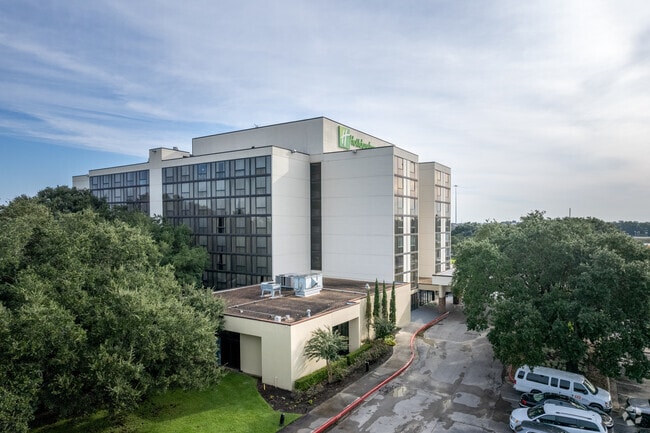

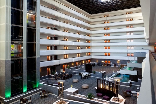
Property Detail
3950 Interstate 10 S
Beaumont-Port Arthur, TX
T H LANGHAM S/D B1 TR 4 7.3879 AB 59 B18 TR 10-B C WILLIAMS .104AC HOLIDAY IN TRACT WALDEN RD @ IH-10
036090-000-000550-00000
Jefferson
Commercialnec
Texas
2024
7.39 AC
2025
Beaumont
001303
Beaumont/Port Arthur
213,450 SF
NEARBY LISTINGS FOR SALE OR LEASE
DEMOGRAPHICS near 3950 Interstate 10 S
1 mile
3 mile
5 mile
2025 Total Population
463
22,293
77,919
2030 Population
455
22,224
77,670
Pop Growth 2025-2030
(1.73%)
(0.31%)
(0.32%)
Average Age
43
40
39
2025 Total Households
202
8,826
30,348
HH Growth 2025-2030
(1.49%)
(0.40%)
(0.38%)
Median Household Inc
$61,990
$59,984
$63,791
Avg Household Size
2.30
2.40
2.40
2025 Avg HH Vehicles
2.00
2.00
2.00
Median Home Value
$199,999
$173,191
$169,196
Median Year Built
1986
1976
1974
Nearby Places
Map Layers
Map Styles
 Street
 Aerial
Transit
 Traffic
 Biking
Places
Listings with unknown addresses are not visible on the map
- Restaurants
- Banks
- Shops
- Fitness
- Groceries
PUBLIC TRANSPORTATION
COMMUTER RAIL
Beaumont Amtrak (Sunset Limited - Amtrak)
Drive
Walk
Distance
Beaumont Amtrak (Sunset Limited - Amtrak)
6 min
3.8 mi
Freight Ports
Port Beaumont
Drive
Walk
Distance
Port Beaumont
9 min
5.5 mi
SALE & LEASE HISTORY
LISTING DATE
SALE/LEASE

Nov 10, 2017
For Sale
Dec 20, 2017
For Sale
Nearby Properties
Address
Land Use
TOTAL SIZE
Lot Size
Zoning
Address
Land Use
TOTAL SIZE
Lot Size
Zoning
373,397 SF
21.07 AC
Address
Land Use
TOTAL SIZE
Lot Size
Zoning
382,144 SF
155.45 AC
Address
Land Use
TOTAL SIZE
Lot Size
Zoning
104,163 SF
12.77 AC
Address
Land Use
TOTAL SIZE
Lot Size
Zoning
96,502 SF
1.46 AC
Address
Land Use
TOTAL SIZE
Lot Size
Zoning
110,109 SF
6 AC
Address
Land Use
TOTAL SIZE
Lot Size
Zoning
31,914 SF
2.80 AC
Address
Land Use
TOTAL SIZE
Lot Size
Zoning
266,107 SF
10.38 AC
Address
Land Use
TOTAL SIZE
Lot Size
Zoning
82,595 SF
29.48 AC
Address
Land Use
TOTAL SIZE
Lot Size
Zoning
48,600 SF
4.87 AC
Address
Land Use
TOTAL SIZE
Lot Size
Zoning
57,326 SF
2.32 AC
Address
Land Use
TOTAL SIZE
Lot Size
Zoning
250,157 SF
17.65 AC
Address
Land Use
TOTAL SIZE
Lot Size
Zoning
14,691 SF
2.50 AC
Address
Land Use
TOTAL SIZE
Lot Size
Zoning
56,916 SF
13.76 AC
Address
Land Use
TOTAL SIZE
Lot Size
Zoning
79,125 SF
8.09 AC
Address
Land Use
TOTAL SIZE
Lot Size
Zoning
112,290 SF
4.22 AC
Address
Land Use
TOTAL SIZE
Lot Size
Zoning
124,800 SF
9.34 AC
Address
Land Use
TOTAL SIZE
Lot Size
Zoning
61,175 SF
4.38 AC
Address
Land Use
TOTAL SIZE
Lot Size
Zoning
122,954 SF
8.63 AC
Address
Land Use
TOTAL SIZE
Lot Size
Zoning
81,868 SF
8.05 AC
Address
Land Use
TOTAL SIZE
Lot Size
Zoning
65,335 SF
11.51 AC
Address
Land Use
TOTAL SIZE
Lot Size
Zoning
61,010 SF
5.28 AC
Address
Land Use
TOTAL SIZE
Lot Size
Zoning
124,838 SF
11.80 AC
Address
Land Use
TOTAL SIZE
Lot Size
Zoning
49,034 SF
5.32 AC
Address
Land Use
TOTAL SIZE
Lot Size
Zoning
83,490 SF
10.93 AC
Address
Land Use
TOTAL SIZE
Lot Size
Zoning
23,326 SF
11.74 AC
Address
Land Use
TOTAL SIZE
Lot Size
Zoning
75,210 SF
3.10 AC
Address
Land Use
TOTAL SIZE
Lot Size
Zoning
101,083 SF
3.16 AC
Address
Land Use
TOTAL SIZE
Lot Size
Zoning
45,141 SF
2.93 AC
Address
Land Use
TOTAL SIZE
Lot Size
Zoning
62,600 SF
20 AC
The World's #1 Commercial Real Estate Marketplace
Connect with us
© 2026 CoStar Group
The information above has been obtained from sources believed reliable. While we do not doubt its accuracy we have not verified it and make no guarantee, warranty or representation about it. It is your responsibility to independently confirm its accuracy and completeness. Any projections, opinions, assumptions, or estimates used are for example only and do not represent the current or future performance of the property. The value of this transaction to you depends on tax and other factors which should be evaluated by your tax, financial, and legal advisors. You and your advisors should conduct a careful, independent investigation of the property to determine to your satisfaction the suitability of the property for your needs.