Property Record
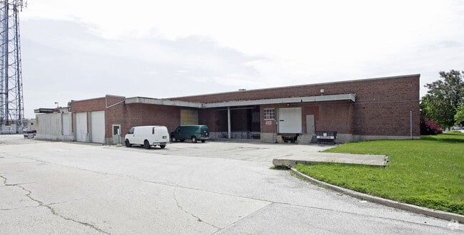
3950 N Holton St, Milwaukee, WI 53212


Current Lease Availabilities
NEARBY LISTINGS FOR SALE OR LEASE
Property Detail
3950 N Holton St
Milwaukee-Waukesha, WI
Certified
274-0361-100-5
CERTIFIED SURVEY MAP NO 3681 IN NW 1/4 SEC 9-7-22 PARCEL 1 EXC PT DESC COM NE COR PARCEL 10TH S ALG E LI 86.53 TO A PT-TH W ALG S LI OF PARCEL 1 302.14-TH N 102.68-TH E ALG N LI 131.66-TH S 13.36-TH E 170 TO PT OF BEG BID #25
Warehouse
Milwaukee
X
Wisconsin
55079C0084E
1
2024
3.15 AC
2024
Milwaukee East
004400
Milwaukee/Madison
51,466 SF
DEMOGRAPHICS near 3950 N Holton St
1 Mile
3 Mile
5 Mile
2024 Total Population
19,715
160,360
326,211
2029 Population
19,362
158,281
321,913
Pop Growth 2024-2029
(1.79%)
(1.30%)
(1.32%)
Average Age
38
36
36
2024 Total Households
9,230
71,996
139,910
HH Growth 2024-2029
(2.09%)
(1.46%)
(1.37%)
Median Household Inc
$51,039
$47,634
$44,377
Avg Household Size
2.10
2.10
2.20
2024 Avg HH Vehicles
1.00
1.00
1.00
Median Home Value
$255,901
$238,779
$190,654
Median Year Built
1948
1948
1948
Nearby Places
Map Layers
Map Styles
 Street
 Aerial
- Restaurants
- Banks
- Shops
- Fitness
- Groceries
PUBLIC TRANSPORTATION
COMMUTER RAIL
DRIVE
WALK
Distance
12 min
4.4 mi
AIRPORT
General Mitchell International
DRIVE
WALK
Distance
General Mitchell International
23 min
12.3 mi
Freight Ports
Port Milwaukee
DRIVE
WALK
Distance
Port Milwaukee
15 min
8.2 mi
Nearby Properties
Address
Land Use
TOTAL SIZE
Lot Size
Zoning
Address
Land Use
TOTAL SIZE
Lot Size
Zoning
237,850 SF
5.02 AC
RM7
Address
Land Use
TOTAL SIZE
Lot Size
Zoning
26.11 AC
TL
Address
Land Use
TOTAL SIZE
Lot Size
Zoning
280,000 SF
2.74 AC
RED
Address
Land Use
TOTAL SIZE
Lot Size
Zoning
417,704 SF
0.81 AC
PD
Address
Land Use
TOTAL SIZE
Lot Size
Zoning
535,904 SF
3.88 AC
C9A(A)
Address
Land Use
TOTAL SIZE
Lot Size
Zoning
300,416 SF
1.24 AC
PD
Address
Land Use
TOTAL SIZE
Lot Size
Zoning
382,921 SF
2.81 AC
PD
Address
Land Use
TOTAL SIZE
Lot Size
Zoning
180,407 SF
0.63 AC
PD
Address
Land Use
TOTAL SIZE
Lot Size
Zoning
42.90 AC
TL
Address
Land Use
TOTAL SIZE
Lot Size
Zoning
508,168 SF
14.56 AC
C9G
Address
Land Use
TOTAL SIZE
Lot Size
Zoning
162,000 SF
0.83 AC
PD
Address
Land Use
TOTAL SIZE
Lot Size
Zoning
305,573 SF
3.20 AC
Address
Land Use
TOTAL SIZE
Lot Size
Zoning
66,245 SF
10.21 AC
Address
Land Use
TOTAL SIZE
Lot Size
Zoning
0.07 AC
RS6
Address
Land Use
TOTAL SIZE
Lot Size
Zoning
0.09 AC
LB2
Address
Land Use
TOTAL SIZE
Lot Size
Zoning
12.97 AC
TL
Address
Land Use
TOTAL SIZE
Lot Size
Zoning
85,000 SF
1.13 AC
Address
Land Use
TOTAL SIZE
Lot Size
Zoning
247,344 SF
1.44 AC
RED
Address
Land Use
TOTAL SIZE
Lot Size
Zoning
685,390 SF
26.20 AC
Address
Land Use
TOTAL SIZE
Lot Size
Zoning
1 SF
5.12 AC
PD
Address
Land Use
TOTAL SIZE
Lot Size
Zoning
152,640 SF
10.50 AC
Address
Land Use
TOTAL SIZE
Lot Size
Zoning
150,370 SF
2.46 AC
C9G
Address
Land Use
TOTAL SIZE
Lot Size
Zoning
171,170 SF
25.88 AC
Address
Land Use
TOTAL SIZE
Lot Size
Zoning
12.74 AC
TL
Address
Land Use
TOTAL SIZE
Lot Size
Zoning
189,063 SF
2.35 AC
RED
Address
Land Use
TOTAL SIZE
Lot Size
Zoning
230,828 SF
0.87 AC
RM7
Address
Land Use
TOTAL SIZE
Lot Size
Zoning
193,988 SF
1.28 AC
C9G
Address
Land Use
TOTAL SIZE
Lot Size
Zoning
214,461 SF
0.49 AC
PD
Address
Land Use
TOTAL SIZE
Lot Size
Zoning
224,756 SF
12 AC
RESIDENTIA
Address
Land Use
TOTAL SIZE
Lot Size
Zoning
145,605 SF
2.64 AC
The World's #1 Commercial Real Estate Marketplace
Connect with us
© 2026 CoStar Group
The information above has been obtained from sources believed reliable. While we do not doubt its accuracy we have not verified it and make no guarantee, warranty or representation about it. It is your responsibility to independently confirm its accuracy and completeness. Any projections, opinions, assumptions, or estimates used are for example only and do not represent the current or future performance of the property. The value of this transaction to you depends on tax and other factors which should be evaluated by your tax, financial, and legal advisors. You and your advisors should conduct a careful, independent investigation of the property to determine to your satisfaction the suitability of the property for your needs.