Property Record
3950 Round Bottom Rd, Cincinnati, OH 45244
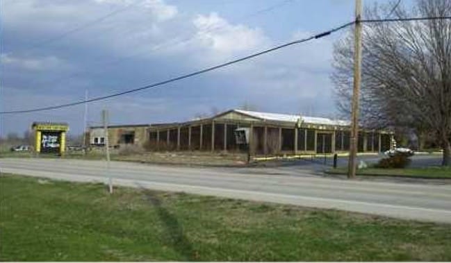
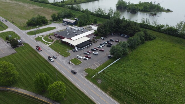

Property Detail
3950 Round Bottom Rd
Cincinnati, OH-KY-IN
ES ROUND BOTTOM RD 1.881 AC ANDERSONS MS 427
500-0240-0022
HAMILTON
Commercialnec
Ohio
AE The base floodplain where base flood elevations are provided. AE Zones are now used on new format FIRMs instead of A1-A30 Zones.
1.43 AC
2025
Eastgate/Anderson Twp
2025
Cincinnati/Dayton
024901
NEARBY LISTINGS FOR SALE OR LEASE
DEMOGRAPHICS near 3950 Round Bottom Rd
1 mile
3 mile
5 mile
2025 Total Population
1,202
33,989
135,523
2030 Population
1,215
34,283
136,933
Pop Growth 2025-2030
+ 1.08%
+ 0.86%
+ 1.04%
Average Age
41
40
41
2025 Total Households
453
13,144
57,229
HH Growth 2025-2030
+ 1.10%
+ 1.10%
+ 1.22%
Median Household Inc
$70,714
$105,017
$90,940
Avg Household Size
2.60
2.60
2.30
2025 Avg HH Vehicles
2.00
2.00
2.00
Median Home Value
$652,343
$422,173
$340,211
Median Year Built
1971
1970
1969
Nearby Places
Map Layers
Map Styles
 Street
 Aerial
Transit
 Traffic
 Biking
Places
Listings with unknown addresses are not visible on the map
- Restaurants
- Banks
- Shops
- Fitness
- Groceries
PUBLIC TRANSPORTATION
AIRPORT
Cincinnati/Northern Kentucky International
Drive
Walk
Distance
Cincinnati/Northern Kentucky International
48 min
27.3 mi
Freight Ports
Port of Toledo
Drive
Walk
Distance
Port of Toledo
250 min
210.6 mi
SALE & LEASE HISTORY
LISTING DATE
SALE/LEASE

Jun 01, 2022
For Sale
Nearby Properties
Address
Land Use
TOTAL SIZE
Lot Size
Zoning
Address
Land Use
TOTAL SIZE
Lot Size
Zoning
1,205 SF
41.47 AC
Address
Land Use
TOTAL SIZE
Lot Size
Zoning
25.51 AC
Address
Land Use
TOTAL SIZE
Lot Size
Zoning
20.38 AC
Address
Land Use
TOTAL SIZE
Lot Size
Zoning
49.27 AC
Address
Land Use
TOTAL SIZE
Lot Size
Zoning
8.99 AC
Address
Land Use
TOTAL SIZE
Lot Size
Zoning
1,134,029 SF
229.73 AC
Address
Land Use
TOTAL SIZE
Lot Size
Zoning
7.49 AC
Address
Land Use
TOTAL SIZE
Lot Size
Zoning
28.27 AC
Address
Land Use
TOTAL SIZE
Lot Size
Zoning
6.55 AC
Address
Land Use
TOTAL SIZE
Lot Size
Zoning
55,848 SF
12.51 AC
Address
Land Use
TOTAL SIZE
Lot Size
Zoning
49.66 AC
Address
Land Use
TOTAL SIZE
Lot Size
Zoning
9.59 AC
Address
Land Use
TOTAL SIZE
Lot Size
Zoning
1,628 SF
43.10 AC
SF6
Address
Land Use
TOTAL SIZE
Lot Size
Zoning
Address
Land Use
TOTAL SIZE
Lot Size
Zoning
13.89 AC
Address
Land Use
TOTAL SIZE
Lot Size
Zoning
19,843 SF
4 AC
Address
Land Use
TOTAL SIZE
Lot Size
Zoning
102,891 SF
20.87 AC
Address
Land Use
TOTAL SIZE
Lot Size
Zoning
Address
Land Use
TOTAL SIZE
Lot Size
Zoning
14,223 SF
7.22 AC
Address
Land Use
TOTAL SIZE
Lot Size
Zoning
27,957 SF
29.54 AC
Address
Land Use
TOTAL SIZE
Lot Size
Zoning
14.28 AC
DD
Address
Land Use
TOTAL SIZE
Lot Size
Zoning
3,282 SF
1.47 AC
B
Address
Land Use
TOTAL SIZE
Lot Size
Zoning
70.36 AC
A
Address
Land Use
TOTAL SIZE
Lot Size
Zoning
17,485 SF
24.29 AC
Address
Land Use
TOTAL SIZE
Lot Size
Zoning
5.97 AC
EPUDSPI
Address
Land Use
TOTAL SIZE
Lot Size
Zoning
7.45 AC
Address
Land Use
TOTAL SIZE
Lot Size
Zoning
17,281 SF
7.80 AC
Address
Land Use
TOTAL SIZE
Lot Size
Zoning
39,257 SF
11.54 AC
Address
Land Use
TOTAL SIZE
Lot Size
Zoning
35.56 AC
A
Address
Land Use
TOTAL SIZE
Lot Size
Zoning
7,360 SF
1.33 AC
The World's #1 Commercial Real Estate Marketplace
Connect with us
© 2026 CoStar Group
The information above has been obtained from sources believed reliable. While we do not doubt its accuracy we have not verified it and make no guarantee, warranty or representation about it. It is your responsibility to independently confirm its accuracy and completeness. Any projections, opinions, assumptions, or estimates used are for example only and do not represent the current or future performance of the property. The value of this transaction to you depends on tax and other factors which should be evaluated by your tax, financial, and legal advisors. You and your advisors should conduct a careful, independent investigation of the property to determine to your satisfaction the suitability of the property for your needs.