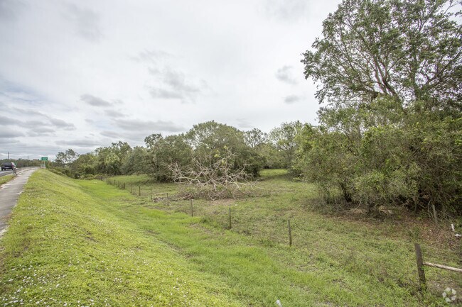
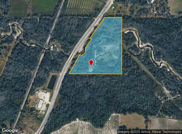
Property Record
3950 Sw Highway 17, Arcadia, FL 34266
NEARBY LISTINGS FOR SALE OR LEASE
Property Detail
3950 Sw Highway 17
14-38-24-0000-0110-0000
THAT PART OF S1/2 OF SE1/4 LYG E OF HWY SUBJ TO UTE ESMT & ESMT IN OR 289/298 LESS ADDNL R/W TO SR 35 PER OR 342/546 OR 211/1312 INST:201514006639 INST:202014006415 INST:202214001908 INST:202414002675
Lightindustrial
DeSoto
AE
Florida
12027C0167C
27.29 AC
2024
Florida Central South Area
2024
Other Market Areas
010406
Arcadia, FL
5,696 SF
DEMOGRAPHICS near 3950 Sw Highway 17
1 Mile
3 Mile
5 Mile
2024 Total Population
685
7,991
22,976
2029 Population
762
8,841
25,369
Pop Growth 2024-2029
+ 11.24%
+ 10.64%
+ 10.42%
Average Age
37
37
39
2024 Total Households
226
2,734
7,875
HH Growth 2024-2029
+ 12.39%
+ 11.49%
+ 11.40%
Median Household Inc
$40,312
$37,794
$34,408
Avg Household Size
3.00
2.90
2.80
2024 Avg HH Vehicles
2.00
2.00
2.00
Median Home Value
$109,722
$95,407
$116,909
Median Year Built
1984
1986
1983
Nearby Places
- Restaurants
- Banks
- Shops
- Fitness
- Groceries
PUBLIC TRANSPORTATION
AIRPORT
Punta Gorda
DRIVE
WALK
Distance
Punta Gorda
34 min
22.8 mi
Freight Ports
Port Manatee
DRIVE
WALK
Distance
Port Manatee
86 min
61.7 mi
SALE & LEASE HISTORY
LISTING DATE
SALE/LEASE

Oct 18, 2017
For Sale
May 15, 2018
For Sale
Dec 28, 2023
For Sale
Aug 04, 2021
For Sale
Nearby Properties
Address
Land Use
TOTAL SIZE
Lot Size
Zoning
Address
Land Use
TOTAL SIZE
Lot Size
Zoning
67,387 SF
46.10 AC
PUD
Address
Land Use
TOTAL SIZE
Lot Size
Zoning
57,048 SF
20.25 AC
PUD
Address
Land Use
TOTAL SIZE
Lot Size
Zoning
83,273 SF
13.94 AC
ROI
Address
Land Use
TOTAL SIZE
Lot Size
Zoning
21,108 SF
3.36 AC
A-5
Address
Land Use
TOTAL SIZE
Lot Size
Zoning
20,008 SF
4.69 AC
A-5
Address
Land Use
TOTAL SIZE
Lot Size
Zoning
1,368 SF
16.90 AC
MHP
Address
Land Use
TOTAL SIZE
Lot Size
Zoning
7,514 SF
121.57 AC
A-5
Address
Land Use
TOTAL SIZE
Lot Size
Zoning
3,200 SF
49.29 AC
RMF-M
Address
Land Use
TOTAL SIZE
Lot Size
Zoning
10,972 SF
6.77 AC
RSF-3
Address
Land Use
TOTAL SIZE
Lot Size
Zoning
22,414 SF
5.02 AC
R-1C
Address
Land Use
TOTAL SIZE
Lot Size
Zoning
50,951 SF
47.23 AC
IH
Address
Land Use
TOTAL SIZE
Lot Size
Zoning
47,950 SF
5.66 AC
IL
Address
Land Use
TOTAL SIZE
Lot Size
Zoning
96 SF
95.92 AC
A-10
Address
Land Use
TOTAL SIZE
Lot Size
Zoning
7,307 SF
305.60 AC
A-5
Address
Land Use
TOTAL SIZE
Lot Size
Zoning
7,895 SF
2.47 AC
CG
Address
Land Use
TOTAL SIZE
Lot Size
Zoning
4,220 SF
312.23 AC
A-5
Address
Land Use
TOTAL SIZE
Lot Size
Zoning
7,953 SF
1.22 AC
B-3
Address
Land Use
TOTAL SIZE
Lot Size
Zoning
13,642 SF
124.26 AC
A-5
Address
Land Use
TOTAL SIZE
Lot Size
Zoning
4,380 SF
4.28 AC
RMF-6
Address
Land Use
TOTAL SIZE
Lot Size
Zoning
4,404 SF
37.41 AC
A-5
Address
Land Use
TOTAL SIZE
Lot Size
Zoning
12,037 SF
2.79 AC
CG
Address
Land Use
TOTAL SIZE
Lot Size
Zoning
4,968 SF
10.19 AC
IL
Address
Land Use
TOTAL SIZE
Lot Size
Zoning
4,354 SF
54.99 AC
A-10
Address
Land Use
TOTAL SIZE
Lot Size
Zoning
7,555 SF
1.21 AC
RM
Address
Land Use
TOTAL SIZE
Lot Size
Zoning
9,230 SF
1.29 AC
CG
Address
Land Use
TOTAL SIZE
Lot Size
Zoning
11,232 SF
2.65 AC
RMF-M
Address
Land Use
TOTAL SIZE
Lot Size
Zoning
4,310 SF
0.51 AC
RMF-M
Address
Land Use
TOTAL SIZE
Lot Size
Zoning
5,329 SF
15.27 AC
A-5
Address
Land Use
TOTAL SIZE
Lot Size
Zoning
3,720 SF
148.02 AC
A-5
The World's #1 Commercial Real Estate Marketplace
Connect with us
© 2025 CoStar Group
The information above has been obtained from sources believed reliable. While we do not doubt its accuracy we have not verified it and make no guarantee, warranty or representation about it. It is your responsibility to independently confirm its accuracy and completeness. Any projections, opinions, assumptions, or estimates used are for example only and do not represent the current or future performance of the property. The value of this transaction to you depends on tax and other factors which should be evaluated by your tax, financial, and legal advisors. You and your advisors should conduct a careful, independent investigation of the property to determine to your satisfaction the suitability of the property for your needs.