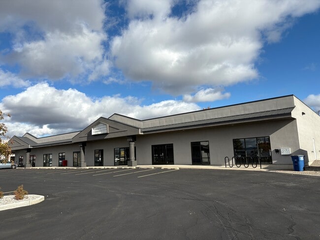
Property Record
3920 W 5Th Ave, Post Falls, ID 83854


Current Lease Availabilities
NEARBY LISTINGS FOR SALE OR LEASE
Property Detail
3920 W 5Th Ave
P390005041AD
Greenacres
Storebuilding
EAST GREENACRES IRR DISTRICT PLAT 9, TRS 41 & 56 LYING N OF HWY EX E 230 FT EX TX#13831 EX RW, W 50 FT-E 230 FT-TRS 41 & 56
X
Kootenai
53063C0610D
Idaho
2025
4.59 AC
2025
Post Falls
000401
Coeur D'Alene
33,124 SF
Coeur d'Alene, ID
DEMOGRAPHICS near 3920 W 5Th Ave
1 Mile
3 Mile
5 Mile
2024 Total Population
4,821
23,286
60,890
2029 Population
5,789
27,499
71,225
Pop Growth 2024-2029
+ 20.08%
+ 18.09%
+ 16.97%
Average Age
37
38
39
2024 Total Households
1,836
8,607
22,660
HH Growth 2024-2029
+ 19.77%
+ 17.94%
+ 16.82%
Median Household Inc
$53,237
$64,552
$71,998
Avg Household Size
2.50
2.60
2.60
2024 Avg HH Vehicles
2.00
2.00
2.00
Median Home Value
$404,086
$401,798
$409,402
Median Year Built
2006
1999
2000
Nearby Places
Map Layers
Map Styles
 Street
 Aerial
- Restaurants
- Banks
- Shops
- Fitness
- Groceries
PUBLIC TRANSPORTATION
AIRPORT
Spokane International
DRIVE
WALK
Distance
Spokane International
36 min
27.2 mi
Nearby Properties
Address
Land Use
TOTAL SIZE
Lot Size
Zoning
Address
Land Use
TOTAL SIZE
Lot Size
Zoning
182,288 SF
45.50 AC
MZ
Address
Land Use
TOTAL SIZE
Lot Size
Zoning
53,118 SF
7.61 AC
Address
Land Use
TOTAL SIZE
Lot Size
Zoning
150,900 SF
7.24 AC
AG
Address
Land Use
TOTAL SIZE
Lot Size
Zoning
42,636 SF
24.81 AC
Address
Land Use
TOTAL SIZE
Lot Size
Zoning
235,906 SF
13.17 AC
Address
Land Use
TOTAL SIZE
Lot Size
Zoning
25,698 SF
11.33 AC
Address
Land Use
TOTAL SIZE
Lot Size
Zoning
465,080 SF
31.43 AC
Address
Land Use
TOTAL SIZE
Lot Size
Zoning
145,377 SF
35.35 AC
Address
Land Use
TOTAL SIZE
Lot Size
Zoning
26,619 SF
15 AC
Address
Land Use
TOTAL SIZE
Lot Size
Zoning
165,984 SF
9.61 AC
Address
Land Use
TOTAL SIZE
Lot Size
Zoning
129,238 SF
24.58 AC
AG
Address
Land Use
TOTAL SIZE
Lot Size
Zoning
82,700 SF
21 AC
Address
Land Use
TOTAL SIZE
Lot Size
Zoning
156,211 SF
17.09 AC
Address
Land Use
TOTAL SIZE
Lot Size
Zoning
199,920 SF
18.36 AC
COMDEV
Address
Land Use
TOTAL SIZE
Lot Size
Zoning
108,524 SF
20.34 AC
Address
Land Use
TOTAL SIZE
Lot Size
Zoning
85,000 SF
1.22 AC
Address
Land Use
TOTAL SIZE
Lot Size
Zoning
64,648 SF
14.82 AC
AG
Address
Land Use
TOTAL SIZE
Lot Size
Zoning
60,246 SF
3.67 AC
Address
Land Use
TOTAL SIZE
Lot Size
Zoning
103,056 SF
8.18 AC
Address
Land Use
TOTAL SIZE
Lot Size
Zoning
56,150 SF
1.56 AC
Address
Land Use
TOTAL SIZE
Lot Size
Zoning
115,992 SF
6.87 AC
Address
Land Use
TOTAL SIZE
Lot Size
Zoning
21,008 SF
2.53 AC
Address
Land Use
TOTAL SIZE
Lot Size
Zoning
49,802 SF
9.86 AC
Address
Land Use
TOTAL SIZE
Lot Size
Zoning
31,986 SF
15.98 AC
Address
Land Use
TOTAL SIZE
Lot Size
Zoning
70,560 SF
14.69 AC
COMDEV
Address
Land Use
TOTAL SIZE
Lot Size
Zoning
108,441 SF
10.01 AC
COM
Address
Land Use
TOTAL SIZE
Lot Size
Zoning
67,104 SF
4.03 AC
Address
Land Use
TOTAL SIZE
Lot Size
Zoning
66,603 SF
37.87 AC
R-5
Address
Land Use
TOTAL SIZE
Lot Size
Zoning
29,977 SF
2.61 AC
The World's #1 Commercial Real Estate Marketplace
Connect with us
© 2025 CoStar Group
The information above has been obtained from sources believed reliable. While we do not doubt its accuracy we have not verified it and make no guarantee, warranty or representation about it. It is your responsibility to independently confirm its accuracy and completeness. Any projections, opinions, assumptions, or estimates used are for example only and do not represent the current or future performance of the property. The value of this transaction to you depends on tax and other factors which should be evaluated by your tax, financial, and legal advisors. You and your advisors should conduct a careful, independent investigation of the property to determine to your satisfaction the suitability of the property for your needs.