Property Record
3951 Nw Lamonta Rd, Prineville, OR 97754

NEARBY LISTINGS FOR SALE OR LEASE
Property Detail
3951 Nw Lamonta Rd
Prineville, OR
Part Plat Year & # No Parcel #
014464
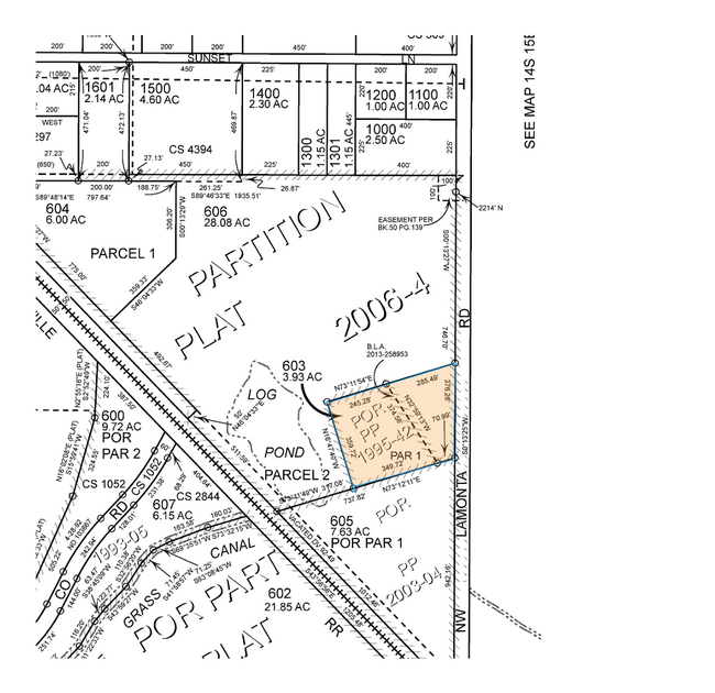
SECTION 23 TOWNSHIP 14S RANGE 15E PCRL 603 SUBDIVISION: PART PLAT YEAR & # NO PARCEL # BLOCK: 95 LOT: 42 MAPTAXLOT: 1415230000603
Industrialgeneral
Crook
A
Oregon
41013C0384C
42
2025
3.93 AC
2025
Bend/Redmond
950401
Other Market Areas
3,456 SF
DEMOGRAPHICS near 3951 Nw Lamonta Rd
1 Mile
3 Mile
5 Mile
2024 Total Population
268
7,957
16,398
2029 Population
306
9,227
18,931
Pop Growth 2024-2029
+ 14.18%
+ 15.96%
+ 15.45%
Average Age
45
42
42
2024 Total Households
108
3,193
6,492
HH Growth 2024-2029
+ 13.89%
+ 16.04%
+ 15.62%
Median Household Inc
$61,875
$60,032
$60,256
Avg Household Size
2.50
2.50
2.50
2024 Avg HH Vehicles
3.00
2.00
2.00
Median Home Value
$385,999
$333,172
$335,121
Median Year Built
1975
1992
1984
Nearby Places
Map Layers
Map Styles
 Street
 Aerial
- Restaurants
- Banks
- Shops
- Fitness
- Groceries
PUBLIC TRANSPORTATION
AIRPORT
Roberts Field
DRIVE
WALK
Distance
Roberts Field
30 min
21.9 mi
Freight Ports
Port of Portland
DRIVE
WALK
Distance
Port of Portland
221 min
147.7 mi
Nearby Properties
Address
Land Use
TOTAL SIZE
Lot Size
Zoning
Address
Land Use
TOTAL SIZE
Lot Size
Zoning
6.16 AC
R2
Address
Land Use
TOTAL SIZE
Lot Size
Zoning
5,240 SF
449.07 AC
HM
Address
Land Use
TOTAL SIZE
Lot Size
Zoning
1 SF
8.02 AC
C2
Address
Land Use
TOTAL SIZE
Lot Size
Zoning
202.87 AC
PR
Address
Land Use
TOTAL SIZE
Lot Size
Zoning
1 SF
13.67 AC
M2
Address
Land Use
TOTAL SIZE
Lot Size
Zoning
5.15 AC
M1
Address
Land Use
TOTAL SIZE
Lot Size
Zoning
12,887 SF
0.70 AC
C1
Address
Land Use
TOTAL SIZE
Lot Size
Zoning
57,708 SF
7.63 AC
HM
Address
Land Use
TOTAL SIZE
Lot Size
Zoning
1 SF
22.48 AC
M2
Address
Land Use
TOTAL SIZE
Lot Size
Zoning
15,026 SF
0.18 AC
C1
Address
Land Use
TOTAL SIZE
Lot Size
Zoning
12,826 SF
0.54 AC
R2
Address
Land Use
TOTAL SIZE
Lot Size
Zoning
39,953 SF
2.07 AC
C2
Address
Land Use
TOTAL SIZE
Lot Size
Zoning
1 SF
2.51 AC
M2
Address
Land Use
TOTAL SIZE
Lot Size
Zoning
22,029 SF
15.85 AC
HM
Address
Land Use
TOTAL SIZE
Lot Size
Zoning
38,500 SF
3.42 AC
M1
Address
Land Use
TOTAL SIZE
Lot Size
Zoning
1 SF
6.89 AC
M1
Address
Land Use
TOTAL SIZE
Lot Size
Zoning
1 SF
8.12 AC
M2
Address
Land Use
TOTAL SIZE
Lot Size
Zoning
2,880 SF
2.84 AC
C2
Address
Land Use
TOTAL SIZE
Lot Size
Zoning
45.66 AC
M1
Address
Land Use
TOTAL SIZE
Lot Size
Zoning
Address
Land Use
TOTAL SIZE
Lot Size
Zoning
13,760 SF
3.96 AC
M1
Address
Land Use
TOTAL SIZE
Lot Size
Zoning
1 SF
6.05 AC
M2
Address
Land Use
TOTAL SIZE
Lot Size
Zoning
6,912 SF
6.42 AC
M1
Address
Land Use
TOTAL SIZE
Lot Size
Zoning
16,848 SF
1.15 AC
C2
Address
Land Use
TOTAL SIZE
Lot Size
Zoning
1 SF
0.98 AC
M1
Address
Land Use
TOTAL SIZE
Lot Size
Zoning
925 SF
2.74 AC
LM
Address
Land Use
TOTAL SIZE
Lot Size
Zoning
1 SF
5.17 AC
M1
Address
Land Use
TOTAL SIZE
Lot Size
Zoning
9,600 SF
5.16 AC
M1
Address
Land Use
TOTAL SIZE
Lot Size
Zoning
40.36 AC
HM
Address
Land Use
TOTAL SIZE
Lot Size
Zoning
The World's #1 Commercial Real Estate Marketplace
Connect with us
© 2025 CoStar Group
The information above has been obtained from sources believed reliable. While we do not doubt its accuracy we have not verified it and make no guarantee, warranty or representation about it. It is your responsibility to independently confirm its accuracy and completeness. Any projections, opinions, assumptions, or estimates used are for example only and do not represent the current or future performance of the property. The value of this transaction to you depends on tax and other factors which should be evaluated by your tax, financial, and legal advisors. You and your advisors should conduct a careful, independent investigation of the property to determine to your satisfaction the suitability of the property for your needs.