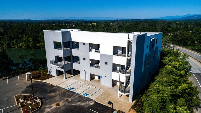
Property Record
3951 S Bonnyview Rd, Redding, CA 96002

Property Detail
3951 S Bonnyview Rd
070-320-001-000
SHASTA
Officebuilding
California
AE The base floodplain where base flood elevations are provided. AE Zones are now used on new format FIRMs instead of A1-A30 Zones.
1.31 AC
2024
Redding/Chico
2025
Other Market Areas
011401
Redding, CA
14,658 SF
NEARBY LISTINGS FOR SALE OR LEASE
DEMOGRAPHICS near 3951 S Bonnyview Rd
1 mile
3 mile
5 mile
2025 Total Population
4,932
47,909
90,295
2030 Population
4,959
48,114
90,568
Pop Growth 2025-2030
+ 0.55%
+ 0.43%
+ 0.30%
Average Age
41
40
41
2025 Total Households
1,879
18,254
36,055
HH Growth 2025-2030
+ 0.53%
+ 0.44%
+ 0.30%
Median Household Inc
$78,971
$80,623
$77,048
Avg Household Size
2.40
2.50
2.40
2025 Avg HH Vehicles
2.00
2.00
2.00
Median Home Value
$358,498
$364,370
$376,572
Median Year Built
1974
1978
1981
Nearby Places
Map Layers
Map Styles
 Street
 Aerial
Layers
 Traffic
 Biking
Places
Listings with unknown addresses are not visible on the map
- Restaurants
- Banks
- Shops
- Fitness
- Groceries
PUBLIC TRANSPORTATION
COMMUTER RAIL
Drive
Walk
Distance
8 min
5.9 mi
AIRPORT
Redding Regional
Drive
Walk
Distance
Redding Regional
8 min
5.1 mi
SALE & LEASE HISTORY
LISTING DATE
SALE/LEASE

Sep 25, 2016
For Lease
Jun 06, 2019
For Lease
Jun 05, 2019
For Sale
Nearby Properties
Address
Land Use
TOTAL SIZE
Lot Size
Zoning
Address
Land Use
TOTAL SIZE
Lot Size
Zoning
151,773 SF
17.64 AC
Address
Land Use
TOTAL SIZE
Lot Size
Zoning
89,098 SF
7.24 AC
Address
Land Use
TOTAL SIZE
Lot Size
Zoning
21,089 SF
7 AC
Address
Land Use
TOTAL SIZE
Lot Size
Zoning
47,062 SF
4.80 AC
Address
Land Use
TOTAL SIZE
Lot Size
Zoning
73,000 SF
4.40 AC
Address
Land Use
TOTAL SIZE
Lot Size
Zoning
143,164 SF
13.90 AC
Address
Land Use
TOTAL SIZE
Lot Size
Zoning
81,800 SF
14.81 AC
Address
Land Use
TOTAL SIZE
Lot Size
Zoning
50,251 SF
4.06 AC
Address
Land Use
TOTAL SIZE
Lot Size
Zoning
61,754 SF
1.73 AC
Address
Land Use
TOTAL SIZE
Lot Size
Zoning
92,699 SF
5.91 AC
Address
Land Use
TOTAL SIZE
Lot Size
Zoning
11.90 AC
Address
Land Use
TOTAL SIZE
Lot Size
Zoning
83,276 SF
3.02 AC
Address
Land Use
TOTAL SIZE
Lot Size
Zoning
16,320 SF
3.76 AC
Address
Land Use
TOTAL SIZE
Lot Size
Zoning
55,351 SF
5.65 AC
Address
Land Use
TOTAL SIZE
Lot Size
Zoning
11.80 AC
Address
Land Use
TOTAL SIZE
Lot Size
Zoning
4.10 AC
Address
Land Use
TOTAL SIZE
Lot Size
Zoning
10.28 AC
Address
Land Use
TOTAL SIZE
Lot Size
Zoning
2.39 AC
Address
Land Use
TOTAL SIZE
Lot Size
Zoning
2.24 AC
Address
Land Use
TOTAL SIZE
Lot Size
Zoning
90,832 SF
12.44 AC
C-2
Address
Land Use
TOTAL SIZE
Lot Size
Zoning
65,920 SF
11.34 AC
Address
Land Use
TOTAL SIZE
Lot Size
Zoning
51,435 SF
4.54 AC
Address
Land Use
TOTAL SIZE
Lot Size
Zoning
61,055 SF
2.87 AC
Address
Land Use
TOTAL SIZE
Lot Size
Zoning
86,744 SF
9.25 AC
Address
Land Use
TOTAL SIZE
Lot Size
Zoning
1.26 AC
Address
Land Use
TOTAL SIZE
Lot Size
Zoning
3,178 SF
3.58 AC
Address
Land Use
TOTAL SIZE
Lot Size
Zoning
30,620 SF
1.85 AC
Address
Land Use
TOTAL SIZE
Lot Size
Zoning
46,114 SF
2.93 AC
Address
Land Use
TOTAL SIZE
Lot Size
Zoning
44,988 SF
3.50 AC
Address
Land Use
TOTAL SIZE
Lot Size
Zoning
125,613 SF
6.81 AC
The World's #1 Commercial Real Estate Marketplace
Connect with us
© 2026 CoStar Group
The information above has been obtained from sources believed reliable. While we do not doubt its accuracy we have not verified it and make no guarantee, warranty or representation about it. It is your responsibility to independently confirm its accuracy and completeness. Any projections, opinions, assumptions, or estimates used are for example only and do not represent the current or future performance of the property. The value of this transaction to you depends on tax and other factors which should be evaluated by your tax, financial, and legal advisors. You and your advisors should conduct a careful, independent investigation of the property to determine to your satisfaction the suitability of the property for your needs.