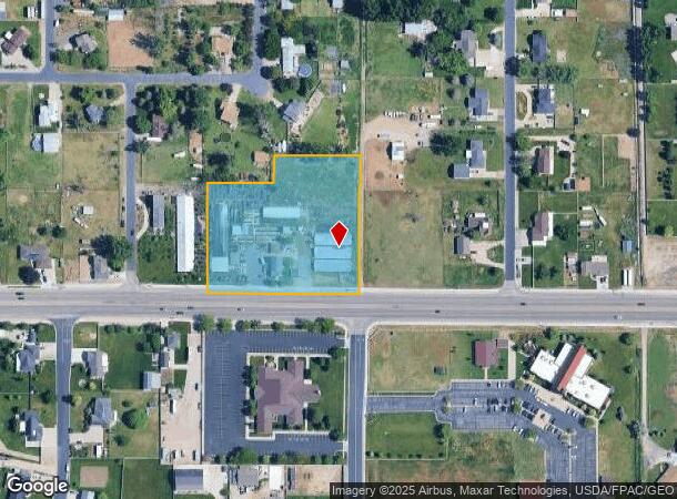
Property Record
3952 W 4000 S, West Haven, UT 84401

NEARBY LISTINGS FOR SALE OR LEASE
Property Detail
3952 W 4000 S
Ogden-Clearfield, UT
White Rail Farms Phase #1
08-206-0002
ALL OF LOTS 1 & 2, WHITE RAIL FARMS PHASE NO. 1, WEST HAVEN CITY, WEBER COUNTY, UTAH. LESS AND EXECPTING: A PARCEL OF LAND IN
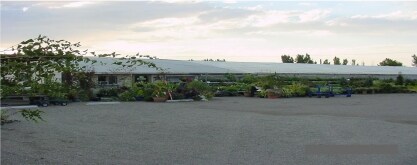
Publicstorage
Weber
X
Utah
49057C0425F
1-3
2025
2.93 AC
2025
Davis/Weber Counties
210517
Salt Lake City
1,350 SF
DEMOGRAPHICS near 3952 W 4000 S
1 Mile
3 Mile
5 Mile
2024 Total Population
9,072
63,170
123,338
2029 Population
10,118
68,152
132,222
Pop Growth 2024-2029
+ 11.53%
+ 7.89%
+ 7.20%
Average Age
35
35
35
2024 Total Households
2,722
20,155
39,304
HH Growth 2024-2029
+ 11.61%
+ 8.00%
+ 7.36%
Median Household Inc
$98,287
$85,333
$81,783
Avg Household Size
3.30
3.10
3.10
2024 Avg HH Vehicles
3.00
3.00
2.00
Median Home Value
$410,591
$361,136
$367,922
Median Year Built
2008
1995
1993
Nearby Places
Map Layers
Map Styles
 Street
 Aerial
- Restaurants
- Banks
- Shops
- Fitness
- Groceries
PUBLIC TRANSPORTATION
COMMUTER RAIL
Roy (FrontRunner North - Utah Transit Authority (UTA))
DRIVE
WALK
Distance
Roy (FrontRunner North - Utah Transit Authority (UTA))
5 min
2.3 mi
Ogden (FrontRunner North - Utah Transit Authority (UTA))
DRIVE
WALK
Distance
Ogden (FrontRunner North - Utah Transit Authority (UTA))
13 min
6.6 mi
AIRPORT
Salt Lake City International
DRIVE
WALK
Distance
Salt Lake City International
49 min
38.3 mi
Freight Ports
Port of Stockton
DRIVE
WALK
Distance
Port of Stockton
749 min
728.7 mi
Nearby Properties
Address
Land Use
TOTAL SIZE
Lot Size
Zoning
Address
Land Use
TOTAL SIZE
Lot Size
Zoning
71,940 SF
11 AC
Address
Land Use
TOTAL SIZE
Lot Size
Zoning
8,580 SF
6.40 AC
Address
Land Use
TOTAL SIZE
Lot Size
Zoning
23,932 SF
5.53 AC
Address
Land Use
TOTAL SIZE
Lot Size
Zoning
50,432 SF
3.86 AC
R115
Address
Land Use
TOTAL SIZE
Lot Size
Zoning
45,772 SF
5 AC
Address
Land Use
TOTAL SIZE
Lot Size
Zoning
1,620 SF
3.74 AC
Address
Land Use
TOTAL SIZE
Lot Size
Zoning
20,010 SF
8.33 AC
Address
Land Use
TOTAL SIZE
Lot Size
Zoning
95,394 SF
8.83 AC
Address
Land Use
TOTAL SIZE
Lot Size
Zoning
56,500 SF
8.02 AC
Address
Land Use
TOTAL SIZE
Lot Size
Zoning
5,714 SF
1.76 AC
Address
Land Use
TOTAL SIZE
Lot Size
Zoning
93,240 SF
7.20 AC
Address
Land Use
TOTAL SIZE
Lot Size
Zoning
305.15 AC
Address
Land Use
TOTAL SIZE
Lot Size
Zoning
71,633 SF
5.12 AC
Address
Land Use
TOTAL SIZE
Lot Size
Zoning
36,662 SF
2.50 AC
Address
Land Use
TOTAL SIZE
Lot Size
Zoning
57,376 SF
3.93 AC
Address
Land Use
TOTAL SIZE
Lot Size
Zoning
7,964 SF
2.49 AC
Address
Land Use
TOTAL SIZE
Lot Size
Zoning
42,865 SF
3.91 AC
Address
Land Use
TOTAL SIZE
Lot Size
Zoning
18,350 SF
1.32 AC
Address
Land Use
TOTAL SIZE
Lot Size
Zoning
22,644 SF
2.07 AC
Address
Land Use
TOTAL SIZE
Lot Size
Zoning
1,500 SF
8.32 AC
Address
Land Use
TOTAL SIZE
Lot Size
Zoning
84,000 SF
2.45 AC
Address
Land Use
TOTAL SIZE
Lot Size
Zoning
60.22 AC
The World's #1 Commercial Real Estate Marketplace
Connect with us
© 2025 CoStar Group
The information above has been obtained from sources believed reliable. While we do not doubt its accuracy we have not verified it and make no guarantee, warranty or representation about it. It is your responsibility to independently confirm its accuracy and completeness. Any projections, opinions, assumptions, or estimates used are for example only and do not represent the current or future performance of the property. The value of this transaction to you depends on tax and other factors which should be evaluated by your tax, financial, and legal advisors. You and your advisors should conduct a careful, independent investigation of the property to determine to your satisfaction the suitability of the property for your needs.