Property Record
3954 Jake Way, Rexburg, ID 83440
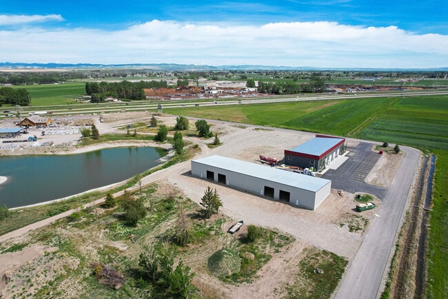

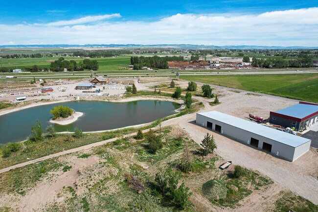
Property Detail
3954 Jake Way
Rexburg, ID
SILVER TIP BUSINESS PARK DIV 1 LOT 14 BLK 1
RP04STB0010140
MADISON
Commercialnec
Idaho
C
14
2025
1.11 AC
2025
Idaho South Area
950304
Other Market Areas
12,000 SF
NEARBY LISTINGS FOR SALE OR LEASE
-
-
View all Rexburg listings for lease on LoopNet.com
DEMOGRAPHICS near 3954 Jake Way
1 mile
3 mile
5 mile
2025 Total Population
455
5,508
45,890
2030 Population
473
5,699
47,644
Pop Growth 2025-2030
+ 3.96%
+ 3.47%
+ 3.82%
Average Age
33
31
27
2025 Total Households
130
1,828
10,731
HH Growth 2025-2030
+ 3.85%
+ 3.88%
+ 4.73%
Median Household Inc
$86,956
$57,438
$54,686
Avg Household Size
3.60
3.00
2.90
2025 Avg HH Vehicles
3.00
2.00
2.00
Median Home Value
$420,689
$399,288
$419,616
Median Year Built
2001
2006
2004
Nearby Places
Map Layers
Map Styles
 Street
 Aerial
Layers
 Traffic
 Biking
Places
Listings with unknown addresses are not visible on the map
- Restaurants
- Banks
- Shops
- Fitness
- Groceries
PUBLIC TRANSPORTATION
AIRPORT
Idaho Falls Regional
Drive
Walk
Distance
Idaho Falls Regional
32 min
24.0 mi
SALE & LEASE HISTORY
LISTING DATE
SALE/LEASE

Sep 21, 2022
For Lease
Jun 13, 2022
For Lease
Nearby Properties
Address
Land Use
TOTAL SIZE
Lot Size
Zoning
Address
Land Use
TOTAL SIZE
Lot Size
Zoning
411,328 SF
16.59 AC
HDR1
Address
Land Use
TOTAL SIZE
Lot Size
Zoning
63,928 SF
1.85 AC
RBC
Address
Land Use
TOTAL SIZE
Lot Size
Zoning
63,501 SF
2.18 AC
RBC
Address
Land Use
TOTAL SIZE
Lot Size
Zoning
2,025 SF
16.95 AC
Address
Land Use
TOTAL SIZE
Lot Size
Zoning
8,750 SF
11.45 AC
LI
Address
Land Use
TOTAL SIZE
Lot Size
Zoning
8,256 SF
22.93 AC
Address
Land Use
TOTAL SIZE
Lot Size
Zoning
37,760 SF
2.11 AC
CBC
Address
Land Use
TOTAL SIZE
Lot Size
Zoning
10,125 SF
6 AC
Address
Land Use
TOTAL SIZE
Lot Size
Zoning
49,766 SF
2.48 AC
CBC
Address
Land Use
TOTAL SIZE
Lot Size
Zoning
10,500 SF
4.18 AC
C
Address
Land Use
TOTAL SIZE
Lot Size
Zoning
17,000 SF
8.65 AC
CBC
Address
Land Use
TOTAL SIZE
Lot Size
Zoning
23,760 SF
1.83 AC
CBC
Address
Land Use
TOTAL SIZE
Lot Size
Zoning
18,750 SF
10.34 AC
CBC
Address
Land Use
TOTAL SIZE
Lot Size
Zoning
20.62 AC
CBC
Address
Land Use
TOTAL SIZE
Lot Size
Zoning
65,400 SF
11.19 AC
C
Address
Land Use
TOTAL SIZE
Lot Size
Zoning
2,381 SF
1.18 AC
RBC
Address
Land Use
TOTAL SIZE
Lot Size
Zoning
14,260 SF
4.63 AC
CBC
Address
Land Use
TOTAL SIZE
Lot Size
Zoning
3,981 SF
1.03 AC
CBC
Address
Land Use
TOTAL SIZE
Lot Size
Zoning
8,504 SF
2.64 AC
Address
Land Use
TOTAL SIZE
Lot Size
Zoning
19,880 SF
5.80 AC
LI
Address
Land Use
TOTAL SIZE
Lot Size
Zoning
14.46 AC
CBC
Address
Land Use
TOTAL SIZE
Lot Size
Zoning
1.09 AC
Address
Land Use
TOTAL SIZE
Lot Size
Zoning
12,460 SF
3.60 AC
C
Address
Land Use
TOTAL SIZE
Lot Size
Zoning
2,965 SF
1 AC
RBC
Address
Land Use
TOTAL SIZE
Lot Size
Zoning
14,500 SF
7.60 AC
C
Address
Land Use
TOTAL SIZE
Lot Size
Zoning
887 SF
10 AC
TAG
Address
Land Use
TOTAL SIZE
Lot Size
Zoning
7,464 SF
1.30 AC
CBC
Address
Land Use
TOTAL SIZE
Lot Size
Zoning
10,600 SF
0.62 AC
LI
Address
Land Use
TOTAL SIZE
Lot Size
Zoning
Address
Land Use
TOTAL SIZE
Lot Size
Zoning
2,323 SF
1.25 AC
CBC
The World's #1 Commercial Real Estate Marketplace
Connect with us
© 2026 CoStar Group
The information above has been obtained from sources believed reliable. While we do not doubt its accuracy we have not verified it and make no guarantee, warranty or representation about it. It is your responsibility to independently confirm its accuracy and completeness. Any projections, opinions, assumptions, or estimates used are for example only and do not represent the current or future performance of the property. The value of this transaction to you depends on tax and other factors which should be evaluated by your tax, financial, and legal advisors. You and your advisors should conduct a careful, independent investigation of the property to determine to your satisfaction the suitability of the property for your needs.