Property Record
3955 Roosevelt Rd, Saint Cloud, MN 56301
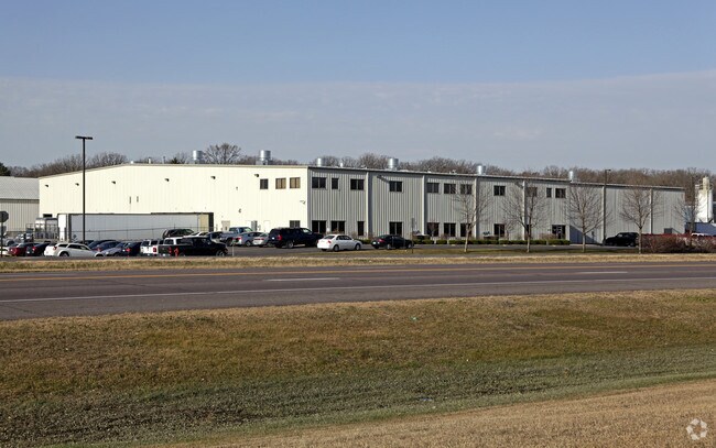

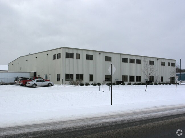
Property Detail
3955 Roosevelt Rd
82.44153.0116
5.23 A. PT OF SW4SW4 BEG ON W LN CO RD 75 DIST 700' SE OF N LN SW4SW4 - S 68 W 433.66' - SE PAR WITH CO RD TO N LN S 33 '
Industrialgeneral
Stearns
C5
Minnesota
B and X Area of moderate flood hazard, usually the area between the limits of the 100-year and 500-year floods.
5.23 AC
2026
Stearns County
2025
Minneapolis/St Paul
000402
St. Cloud, MN
51,000 SF
NEARBY LISTINGS FOR SALE OR LEASE
DEMOGRAPHICS near 3955 Roosevelt Rd
1 mile
3 mile
5 mile
2025 Total Population
2,074
16,593
65,938
2030 Population
2,134
17,313
68,553
Pop Growth 2025-2030
+ 2.89%
+ 4.34%
+ 3.97%
Average Age
36
39
36
2025 Total Households
896
6,086
25,397
HH Growth 2025-2030
+ 2.90%
+ 4.34%
+ 4.06%
Median Household Inc
$76,205
$77,433
$62,514
Avg Household Size
2.30
2.50
2.40
2025 Avg HH Vehicles
2.00
2.00
2.00
Median Home Value
$302,920
$325,560
$244,227
Median Year Built
2004
1993
1981
Nearby Places
Map Layers
Map Styles
 Street
 Aerial
Layers
 Traffic
 Biking
Places
Listings with unknown addresses are not visible on the map
- Restaurants
- Banks
- Shops
- Fitness
- Groceries
PUBLIC TRANSPORTATION
COMMUTER RAIL
St. Cloud Amtrak Station (Empire Builder - Amtrak)
Drive
Walk
Distance
St. Cloud Amtrak Station (Empire Builder - Amtrak)
12 min
5.3 mi
Freight Ports
Port Milwaukee
Drive
Walk
Distance
Port Milwaukee
442 min
399.8 mi
Nearby Properties
Address
Land Use
TOTAL SIZE
Lot Size
Zoning
Address
Land Use
TOTAL SIZE
Lot Size
Zoning
307,404 SF
105.31 AC
Address
Land Use
TOTAL SIZE
Lot Size
Zoning
278,850 SF
20.83 AC
Address
Land Use
TOTAL SIZE
Lot Size
Zoning
15.77 AC
Address
Land Use
TOTAL SIZE
Lot Size
Zoning
19.83 AC
Address
Land Use
TOTAL SIZE
Lot Size
Zoning
24.47 AC
Address
Land Use
TOTAL SIZE
Lot Size
Zoning
357,302 SF
59.30 AC
I3
Address
Land Use
TOTAL SIZE
Lot Size
Zoning
101,460 SF
54.63 AC
I3
Address
Land Use
TOTAL SIZE
Lot Size
Zoning
Address
Land Use
TOTAL SIZE
Lot Size
Zoning
314,315 SF
49.58 AC
I3
Address
Land Use
TOTAL SIZE
Lot Size
Zoning
13.37 AC
Address
Land Use
TOTAL SIZE
Lot Size
Zoning
109,352 SF
77.47 AC
R1
Address
Land Use
TOTAL SIZE
Lot Size
Zoning
79,223 SF
15.58 AC
C5
Address
Land Use
TOTAL SIZE
Lot Size
Zoning
249,445 SF
25.13 AC
I3
Address
Land Use
TOTAL SIZE
Lot Size
Zoning
4.57 AC
Address
Land Use
TOTAL SIZE
Lot Size
Zoning
77,434 SF
7.21 AC
C5
Address
Land Use
TOTAL SIZE
Lot Size
Zoning
6.98 AC
Address
Land Use
TOTAL SIZE
Lot Size
Zoning
15.35 AC
Address
Land Use
TOTAL SIZE
Lot Size
Zoning
55,736 SF
4.60 AC
I1
Address
Land Use
TOTAL SIZE
Lot Size
Zoning
43,250 SF
11.94 AC
Address
Land Use
TOTAL SIZE
Lot Size
Zoning
55,641 SF
18.77 AC
Address
Land Use
TOTAL SIZE
Lot Size
Zoning
169,920 SF
11.19 AC
PUD15
Address
Land Use
TOTAL SIZE
Lot Size
Zoning
74,354 SF
8.71 AC
I3
Address
Land Use
TOTAL SIZE
Lot Size
Zoning
85,428 SF
12.73 AC
AG
Address
Land Use
TOTAL SIZE
Lot Size
Zoning
36,560 SF
5.55 AC
R5
Address
Land Use
TOTAL SIZE
Lot Size
Zoning
87,813 SF
3.73 AC
PUD14
Address
Land Use
TOTAL SIZE
Lot Size
Zoning
57,111 SF
5.69 AC
I3
Address
Land Use
TOTAL SIZE
Lot Size
Zoning
17.94 AC
Address
Land Use
TOTAL SIZE
Lot Size
Zoning
Address
Land Use
TOTAL SIZE
Lot Size
Zoning
67,210 SF
4.55 AC
PUD34
Address
Land Use
TOTAL SIZE
Lot Size
Zoning
60,034 SF
7.73 AC
The World's #1 Commercial Real Estate Marketplace
Connect with us
© 2026 CoStar Group
The information above has been obtained from sources believed reliable. While we do not doubt its accuracy we have not verified it and make no guarantee, warranty or representation about it. It is your responsibility to independently confirm its accuracy and completeness. Any projections, opinions, assumptions, or estimates used are for example only and do not represent the current or future performance of the property. The value of this transaction to you depends on tax and other factors which should be evaluated by your tax, financial, and legal advisors. You and your advisors should conduct a careful, independent investigation of the property to determine to your satisfaction the suitability of the property for your needs.