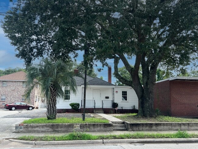
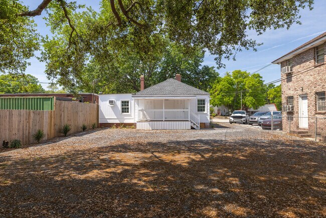
Property Record
3956 Rivers Ave, North Charleston, SC 29405

NEARBY LISTINGS FOR SALE OR LEASE
Property Detail
3956 Rivers Ave
Charleston-North Charleston, SC
Whipper Barony
470-14-00-144
LT 256
Commercialnec
Charleston
X
South Carolina
45019C0501K
256
2025
0.17 AC
2024
North Charleston
003700
Charleston/N Charleston
1,177 SF
DEMOGRAPHICS near 3956 Rivers Ave
1 mile
3 mile
5 mile
2024 Total Population
10,640
41,411
125,184
2029 Population
11,493
44,950
137,393
Pop Growth 2024-2029
+ 8.02%
+ 8.55%
+ 9.75%
Average Age
39
39
39
2024 Total Households
4,625
16,745
52,472
HH Growth 2024-2029
+ 7.89%
+ 8.43%
+ 9.70%
Median Household Inc
$44,568
$44,735
$59,122
Avg Household Size
2.20
2.30
2.20
2024 Avg HH Vehicles
1.00
1.00
2.00
Median Home Value
$195,794
$195,969
$297,977
Median Year Built
1961
1968
1980
Nearby Places
Map Layers
Map Styles
 Street
 Aerial
Transit
 Traffic
 Biking
Places
Listings with unknown addresses are not visible on the map
- Restaurants
- Banks
- Shops
- Fitness
- Groceries
PUBLIC TRANSPORTATION
COMMUTER RAIL
Charleston Amtrak Station (Palmetto - Amtrak, Silver Meteor - Amtrak)
Drive
Walk
Distance
Charleston Amtrak Station (Palmetto - Amtrak, Silver Meteor - Amtrak)
1 min
1.0 mi
AIRPORT
Charleston AFB/International
Drive
Walk
Distance
Charleston AFB/International
14 min
9.0 mi
Freight Ports
Veterans Terminal
Drive
Walk
Distance
Veterans Terminal
5 min
3.0 mi
SALE & LEASE HISTORY
LISTING DATE
SALE/LEASE

Jul 29, 2024
For Sale
Apr 18, 2025
For Sale
Nearby Properties
Address
Land Use
TOTAL SIZE
Lot Size
Zoning
Address
Land Use
TOTAL SIZE
Lot Size
Zoning
1,717 SF
40.95 AC
Address
Land Use
TOTAL SIZE
Lot Size
Zoning
27,900 SF
102.67 AC
Address
Land Use
TOTAL SIZE
Lot Size
Zoning
202,154 SF
16.34 AC
Address
Land Use
TOTAL SIZE
Lot Size
Zoning
68,655 SF
9.48 AC
Address
Land Use
TOTAL SIZE
Lot Size
Zoning
105,666 SF
8.25 AC
Address
Land Use
TOTAL SIZE
Lot Size
Zoning
3,672 SF
3.62 AC
HANAHAN -
Address
Land Use
TOTAL SIZE
Lot Size
Zoning
36,587 SF
17.75 AC
Address
Land Use
TOTAL SIZE
Lot Size
Zoning
10,560 SF
7.50 AC
Address
Land Use
TOTAL SIZE
Lot Size
Zoning
4,740 SF
12.17 AC
Address
Land Use
TOTAL SIZE
Lot Size
Zoning
17,271 SF
3.65 AC
Address
Land Use
TOTAL SIZE
Lot Size
Zoning
112,860 SF
12 AC
Address
Land Use
TOTAL SIZE
Lot Size
Zoning
77,990 SF
8.30 AC
Address
Land Use
TOTAL SIZE
Lot Size
Zoning
23,712 SF
19.34 AC
Address
Land Use
TOTAL SIZE
Lot Size
Zoning
127,156 SF
12.49 AC
Address
Land Use
TOTAL SIZE
Lot Size
Zoning
9,691 SF
10.34 AC
Address
Land Use
TOTAL SIZE
Lot Size
Zoning
19,992 SF
11.98 AC
Address
Land Use
TOTAL SIZE
Lot Size
Zoning
42,500 SF
3.62 AC
Address
Land Use
TOTAL SIZE
Lot Size
Zoning
78,764 SF
4.15 AC
HANAHAN -
Address
Land Use
TOTAL SIZE
Lot Size
Zoning
1,303 SF
4.77 AC
Address
Land Use
TOTAL SIZE
Lot Size
Zoning
15,027 SF
3.62 AC
HANAHAN -
Address
Land Use
TOTAL SIZE
Lot Size
Zoning
3,192 SF
34.47 AC
Address
Land Use
TOTAL SIZE
Lot Size
Zoning
1,575 SF
28.28 AC
Address
Land Use
TOTAL SIZE
Lot Size
Zoning
30,064 SF
33.86 AC
Address
Land Use
TOTAL SIZE
Lot Size
Zoning
16,917 SF
2.40 AC
Address
Land Use
TOTAL SIZE
Lot Size
Zoning
50,356 SF
5.19 AC
Address
Land Use
TOTAL SIZE
Lot Size
Zoning
88,431 SF
7.75 AC
HANAHAN -
Address
Land Use
TOTAL SIZE
Lot Size
Zoning
17,127 SF
2.52 AC
Address
Land Use
TOTAL SIZE
Lot Size
Zoning
25.97 AC
Address
Land Use
TOTAL SIZE
Lot Size
Zoning
11,681 SF
1.16 AC
Address
Land Use
TOTAL SIZE
Lot Size
Zoning
86,024 SF
9.69 AC
The World's #1 Commercial Real Estate Marketplace
Connect with us
© 2026 CoStar Group
The information above has been obtained from sources believed reliable. While we do not doubt its accuracy we have not verified it and make no guarantee, warranty or representation about it. It is your responsibility to independently confirm its accuracy and completeness. Any projections, opinions, assumptions, or estimates used are for example only and do not represent the current or future performance of the property. The value of this transaction to you depends on tax and other factors which should be evaluated by your tax, financial, and legal advisors. You and your advisors should conduct a careful, independent investigation of the property to determine to your satisfaction the suitability of the property for your needs.