Property Record
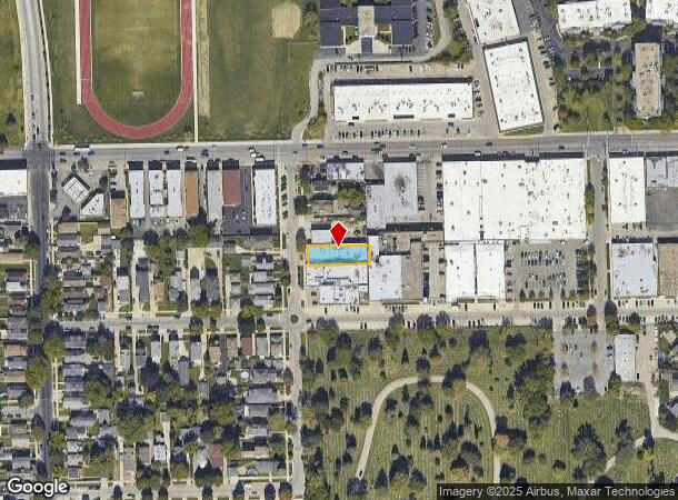
3957 N Normandy Ave, Chicago, IL 60634
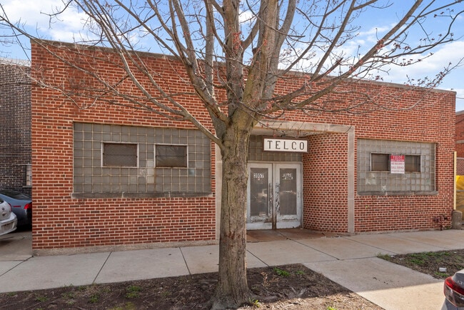
This Property Is For Sale
NEARBY LISTINGS FOR SALE OR LEASE
Property Detail
3957 N Normandy Ave
Chicago-Naperville-Elgin, IL-IN-WI
Dunning Sub
13-19-201-016-0000
D.S.(DUNNING) SUB OF NW NE SEC 19-40-13
Industrialgeneral
Cook
X
Illinois
17031C0385J
16,17
2023
0.19 AC
2024
Northwest City
170300
Chicago
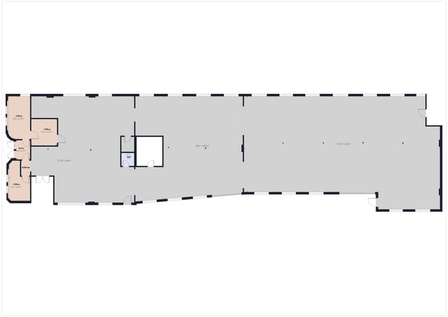
6,441 SF
DEMOGRAPHICS near 3957 N Normandy Ave
1 Mile
3 Mile
5 Mile
2024 Total Population
32,738
292,050
718,112
2029 Population
31,219
276,044
680,341
Pop Growth 2024-2029
(4.64%)
(5.48%)
(5.26%)
Average Age
42
41
40
2024 Total Households
11,861
106,084
267,518
HH Growth 2024-2029
(4.90%)
(5.74%)
(5.50%)
Median Household Inc
$76,455
$75,812
$74,131
Avg Household Size
2.70
2.70
2.60
2024 Avg HH Vehicles
2.00
2.00
2.00
Median Home Value
$307,947
$323,181
$338,840
Median Year Built
1954
1950
1948
Nearby Places
- Restaurants
- Banks
- Shops
- Fitness
- Groceries
PUBLIC TRANSPORTATION
COMMUTER RAIL
Mars Station (Milwaukee District West Line - Northeast Illinois Regional Commuter Railroad (Metra), North Central Service - Northeast Illinois Regional Commuter Railroad (Metra))
DRIVE
WALK
Distance
Mars Station (Milwaukee District West Line - Northeast Illinois Regional Commuter Railroad (Metra), North Central Service - Northeast Illinois Regional Commuter Railroad (Metra))
7 min
2.4 mi
Mont Clare Station (Milwaukee District West Line - Northeast Illinois Regional Commuter Railroad (Metra), North Central Service - Northeast Illinois Regional Commuter Railroad (Metra))
DRIVE
WALK
Distance
Mont Clare Station (Milwaukee District West Line - Northeast Illinois Regional Commuter Railroad (Metra), North Central Service - Northeast Illinois Regional Commuter Railroad (Metra))
7 min
2.5 mi
AIRPORT
Chicago O'Hare International
DRIVE
WALK
Distance
Chicago O'Hare International
17 min
8.3 mi
Chicago Midway International
DRIVE
WALK
Distance
Chicago Midway International
27 min
13.9 mi
Nearby Properties
Address
Land Use
TOTAL SIZE
Lot Size
Zoning
Address
Land Use
TOTAL SIZE
Lot Size
Zoning
192,365 SF
21.34 AC
PD 127
Address
Land Use
TOTAL SIZE
Lot Size
Zoning
237,832 SF
14.04 AC
PD 418
Address
Land Use
TOTAL SIZE
Lot Size
Zoning
9.90 AC
Address
Land Use
TOTAL SIZE
Lot Size
Zoning
1.04 AC
PD 130
Address
Land Use
TOTAL SIZE
Lot Size
Zoning
6.31 AC
PD 1013
Address
Land Use
TOTAL SIZE
Lot Size
Zoning
194,219 SF
17.26 AC
Address
Land Use
TOTAL SIZE
Lot Size
Zoning
3.33 AC
PD 1013
Address
Land Use
TOTAL SIZE
Lot Size
Zoning
100,900 SF
4.85 AC
PD 1415
Address
Land Use
TOTAL SIZE
Lot Size
Zoning
13.33 AC
PD 127
Address
Land Use
TOTAL SIZE
Lot Size
Zoning
349,326 SF
6.50 AC
PD 322
Address
Land Use
TOTAL SIZE
Lot Size
Zoning
277,819 SF
10.58 AC
PD 127
Address
Land Use
TOTAL SIZE
Lot Size
Zoning
897,723 SF
23.04 AC
PMD 15
Address
Land Use
TOTAL SIZE
Lot Size
Zoning
141,095 SF
9.15 AC
PD 127
Address
Land Use
TOTAL SIZE
Lot Size
Zoning
Address
Land Use
TOTAL SIZE
Lot Size
Zoning
154,600 SF
1.62 AC
C2-3
Address
Land Use
TOTAL SIZE
Lot Size
Zoning
240,942 SF
15.94 AC
PD 72
Address
Land Use
TOTAL SIZE
Lot Size
Zoning
36,800 SF
1.01 AC
C2-1
Address
Land Use
TOTAL SIZE
Lot Size
Zoning
126,955 SF
13.70 AC
PD 541
Address
Land Use
TOTAL SIZE
Lot Size
Zoning
71,133 SF
7.28 AC
PD 441
Address
Land Use
TOTAL SIZE
Lot Size
Zoning
63,344 SF
5.01 AC
PD 1069,M1
Address
Land Use
TOTAL SIZE
Lot Size
Zoning
95,614 SF
4.20 AC
Address
Land Use
TOTAL SIZE
Lot Size
Zoning
65,243 SF
3.70 AC
Address
Land Use
TOTAL SIZE
Lot Size
Zoning
138,042 SF
11.74 AC
PD 127
Address
Land Use
TOTAL SIZE
Lot Size
Zoning
306,872 SF
3.61 AC
PD 617
Address
Land Use
TOTAL SIZE
Lot Size
Zoning
0.77 AC
B3-2
Address
Land Use
TOTAL SIZE
Lot Size
Zoning
102,172 SF
2.73 AC
Address
Land Use
TOTAL SIZE
Lot Size
Zoning
65,647 SF
5.69 AC
PD 127
Address
Land Use
TOTAL SIZE
Lot Size
Zoning
7,200 SF
0.31 AC
C1-1
Address
Land Use
TOTAL SIZE
Lot Size
Zoning
91,950 SF
5.30 AC
M2-2
Address
Land Use
TOTAL SIZE
Lot Size
Zoning
212,414 SF
4.36 AC
PD 1415
The World's #1 Commercial Real Estate Marketplace
Connect with us
© 2025 CoStar Group
The information above has been obtained from sources believed reliable. While we do not doubt its accuracy we have not verified it and make no guarantee, warranty or representation about it. It is your responsibility to independently confirm its accuracy and completeness. Any projections, opinions, assumptions, or estimates used are for example only and do not represent the current or future performance of the property. The value of this transaction to you depends on tax and other factors which should be evaluated by your tax, financial, and legal advisors. You and your advisors should conduct a careful, independent investigation of the property to determine to your satisfaction the suitability of the property for your needs.