Property Record
3959 M 139, Saint Joseph, MI 49085
NEARBY LISTINGS FOR SALE OR LEASE
Property Detail
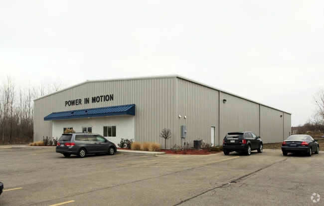
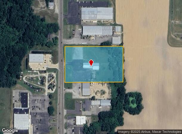
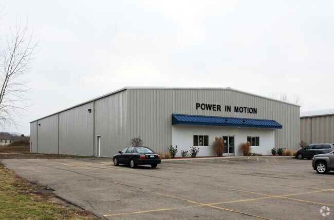
3959 M 139
11-17-0008-0026-15-4
COM 770'N OF SW COR SEC 8 T5S R18W TH N 350'TH N89DEG 50'E 567'TH S 350'TH S89DEG 50'W 567'TO POB EXC THAT PT LYING WLY OF A LN 60'ELY OF (MEAS AT RT ANG & PAR TO)THE FOL LN COM AT SW COR SEC 8 TH S89DEG33'57''W 32.86'TO POB TH N 0 DEG02'14''W 1178.2
Storebuilding
Berrien
X
Michigan
26021C0120C
4.34 AC
2024
Michigan Southwest Area
2025
Other Market Areas
001800
Niles-Benton Harbor, MI
7,890 SF
DEMOGRAPHICS near 3959 M 139
1 Mile
3 Mile
5 Mile
2024 Total Population
1,589
16,165
51,364
2029 Population
1,535
15,715
50,413
Pop Growth 2024-2029
(3.40%)
(2.78%)
(1.85%)
Average Age
43
43
41
2024 Total Households
548
6,611
21,226
HH Growth 2024-2029
(3.83%)
(2.93%)
(2.12%)
Median Household Inc
$109,782
$77,835
$57,675
Avg Household Size
2.70
2.40
2.30
2024 Avg HH Vehicles
2.00
2.00
2.00
Median Home Value
$286,224
$224,305
$217,082
Median Year Built
1981
1969
1965
Nearby Places
Map Layers
Map Styles
 Street
 Aerial
- Restaurants
- Banks
- Shops
- Fitness
- Groceries
PUBLIC TRANSPORTATION
COMMUTER RAIL
St. Joseph-Benton Harbor Amtrak Station (Pere Marquette - Amtrak)
DRIVE
WALK
Distance
St. Joseph-Benton Harbor Amtrak Station (Pere Marquette - Amtrak)
13 min
6.5 mi
AIRPORT
South Bend International
DRIVE
WALK
Distance
South Bend International
43 min
29.0 mi
Freight Ports
Port Milwaukee
DRIVE
WALK
Distance
Port Milwaukee
217 min
181.1 mi
Nearby Properties
Address
Land Use
TOTAL SIZE
Lot Size
Zoning
Address
Land Use
TOTAL SIZE
Lot Size
Zoning
200,321 SF
15.47 AC
D1 COMM
Address
Land Use
TOTAL SIZE
Lot Size
Zoning
218,334 SF
25.05 AC
Address
Land Use
TOTAL SIZE
Lot Size
Zoning
69,180 SF
3.58 AC
D1 COMM
Address
Land Use
TOTAL SIZE
Lot Size
Zoning
73,505 SF
4.02 AC
D1 COMM
Address
Land Use
TOTAL SIZE
Lot Size
Zoning
66,680 SF
3.42 AC
Address
Land Use
TOTAL SIZE
Lot Size
Zoning
296,788 SF
34 AC
D1 COMM
Address
Land Use
TOTAL SIZE
Lot Size
Zoning
258,549 SF
17.20 AC
C MULTI
Address
Land Use
TOTAL SIZE
Lot Size
Zoning
62,800 SF
3.06 AC
Address
Land Use
TOTAL SIZE
Lot Size
Zoning
171,165 SF
15.15 AC
D1 COMM
Address
Land Use
TOTAL SIZE
Lot Size
Zoning
61,732 SF
3.51 AC
D1 COMM
Address
Land Use
TOTAL SIZE
Lot Size
Zoning
42,610 SF
5.30 AC
C4 HEAVY
Address
Land Use
TOTAL SIZE
Lot Size
Zoning
112,503 SF
4.30 AC
C MULTI FA
Address
Land Use
TOTAL SIZE
Lot Size
Zoning
45,270 SF
10.30 AC
C1 GEN COM
Address
Land Use
TOTAL SIZE
Lot Size
Zoning
126,127 SF
11.84 AC
D1 COMM
Address
Land Use
TOTAL SIZE
Lot Size
Zoning
391,928 SF
40.84 AC
F HEAVY
Address
Land Use
TOTAL SIZE
Lot Size
Zoning
84,732 SF
4.19 AC
C MULTI FA
Address
Land Use
TOTAL SIZE
Lot Size
Zoning
77,703 SF
28.05 AC
F HEAVY
Address
Land Use
TOTAL SIZE
Lot Size
Zoning
88,572 SF
15.70 AC
D1 COMM
Address
Land Use
TOTAL SIZE
Lot Size
Zoning
254,984 SF
25.04 AC
R-A RE
Address
Land Use
TOTAL SIZE
Lot Size
Zoning
49,527 SF
4.47 AC
PUD
Address
Land Use
TOTAL SIZE
Lot Size
Zoning
103,591 SF
8.77 AC
D1 COMM
Address
Land Use
TOTAL SIZE
Lot Size
Zoning
69,484 SF
8.08 AC
C MULTI
Address
Land Use
TOTAL SIZE
Lot Size
Zoning
18.05 AC
D1 COMM
Address
Land Use
TOTAL SIZE
Lot Size
Zoning
60,188 SF
3.59 AC
D1 COMM
Address
Land Use
TOTAL SIZE
Lot Size
Zoning
172,489 SF
12.66 AC
E RESTRICT
Address
Land Use
TOTAL SIZE
Lot Size
Zoning
23,923 SF
2.40 AC
D1 COMM
Address
Land Use
TOTAL SIZE
Lot Size
Zoning
9,136 SF
79.96 AC
MH
Address
Land Use
TOTAL SIZE
Lot Size
Zoning
32,066 SF
4.44 AC
Address
Land Use
TOTAL SIZE
Lot Size
Zoning
23,234 SF
3.94 AC
PUD
Address
Land Use
TOTAL SIZE
Lot Size
Zoning
101,006 SF
2.42 AC
D1 COMM
The World's #1 Commercial Real Estate Marketplace
Connect with us
© 2025 CoStar Group
The information above has been obtained from sources believed reliable. While we do not doubt its accuracy we have not verified it and make no guarantee, warranty or representation about it. It is your responsibility to independently confirm its accuracy and completeness. Any projections, opinions, assumptions, or estimates used are for example only and do not represent the current or future performance of the property. The value of this transaction to you depends on tax and other factors which should be evaluated by your tax, financial, and legal advisors. You and your advisors should conduct a careful, independent investigation of the property to determine to your satisfaction the suitability of the property for your needs.