Property Record
Wadesboro Rd, Ponchatoula, LA 70454
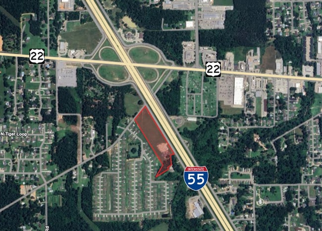


This Property Is For Sale
NEARBY LISTINGS FOR SALE OR LEASE
-
-
View all Ponchatoula listings for sale on LoopNet.com
Property Detail
Wadesboro Rd
06437273
7.69A TOTAL 6.67A BEING TR 2 IN SEC 59 T7SR7E B1472 P662 B1476 P555 B1513 P645 MAP 1476553-555 1510710 XXXXXXXX 1.02A OF A SU
Vacantlandnec
Tangipahoa
X
Louisiana
22063C0300E
7.69 AC
2024
Louisiana South Area
2024
Other Market Areas
954601
Hammond, LA
DEMOGRAPHICS near Wadesboro Rd
1 Mile
3 Mile
5 Mile
2024 Total Population
3,822
19,117
49,226
2029 Population
4,233
21,330
55,112
Pop Growth 2024-2029
+ 10.75%
+ 11.58%
+ 11.96%
Average Age
41
40
39
2024 Total Households
1,543
7,628
19,369
HH Growth 2024-2029
+ 11.28%
+ 12.14%
+ 12.58%
Median Household Inc
$53,994
$54,000
$55,866
Avg Household Size
2.40
2.50
2.40
2024 Avg HH Vehicles
2.00
2.00
2.00
Median Home Value
$214,573
$216,443
$202,013
Median Year Built
2000
2000
1998
Nearby Places
Map Layers
Map Styles
 Street
 Aerial
- Restaurants
- Banks
- Shops
- Fitness
- Groceries
PUBLIC TRANSPORTATION
COMMUTER RAIL
Hammond Amtrak Station (City of New Orleans - Amtrak)
DRIVE
WALK
Distance
Hammond Amtrak Station (City of New Orleans - Amtrak)
9 min
5.7 mi
Freight Ports
Port of New Orleans
DRIVE
WALK
Distance
Port of New Orleans
68 min
54.3 mi
Nearby Properties
Address
Land Use
TOTAL SIZE
Lot Size
Zoning
Address
Land Use
TOTAL SIZE
Lot Size
Zoning
22.56 AC
Address
Land Use
TOTAL SIZE
Lot Size
Zoning
152,841 SF
20.69 AC
Address
Land Use
TOTAL SIZE
Lot Size
Zoning
84,000 SF
8.32 AC
Address
Land Use
TOTAL SIZE
Lot Size
Zoning
82,860 SF
11.42 AC
Address
Land Use
TOTAL SIZE
Lot Size
Zoning
24,931 SF
2.67 AC
Address
Land Use
TOTAL SIZE
Lot Size
Zoning
24,823 SF
3 AC
Address
Land Use
TOTAL SIZE
Lot Size
Zoning
236,540 SF
36.01 AC
Address
Land Use
TOTAL SIZE
Lot Size
Zoning
36,593 SF
1.54 AC
Address
Land Use
TOTAL SIZE
Lot Size
Zoning
27,215 SF
7.58 AC
Address
Land Use
TOTAL SIZE
Lot Size
Zoning
96,064 SF
5.03 AC
Address
Land Use
TOTAL SIZE
Lot Size
Zoning
20,128 SF
20.77 AC
Address
Land Use
TOTAL SIZE
Lot Size
Zoning
22,507 SF
0.63 AC
Address
Land Use
TOTAL SIZE
Lot Size
Zoning
120,800 SF
10 AC
Address
Land Use
TOTAL SIZE
Lot Size
Zoning
10,753 SF
1.57 AC
Address
Land Use
TOTAL SIZE
Lot Size
Zoning
24,040 SF
2.08 AC
Address
Land Use
TOTAL SIZE
Lot Size
Zoning
80,000 SF
11.02 AC
Address
Land Use
TOTAL SIZE
Lot Size
Zoning
11,595 SF
25.66 AC
Address
Land Use
TOTAL SIZE
Lot Size
Zoning
10,944 SF
2.16 AC
Address
Land Use
TOTAL SIZE
Lot Size
Zoning
16,780 SF
8.41 AC
Address
Land Use
TOTAL SIZE
Lot Size
Zoning
13,288 SF
15.07 AC
Address
Land Use
TOTAL SIZE
Lot Size
Zoning
67,728 SF
6.78 AC
Address
Land Use
TOTAL SIZE
Lot Size
Zoning
96,000 SF
7.29 AC
Address
Land Use
TOTAL SIZE
Lot Size
Zoning
12,021 SF
1.15 AC
Address
Land Use
TOTAL SIZE
Lot Size
Zoning
10,692 SF
5.49 AC
Address
Land Use
TOTAL SIZE
Lot Size
Zoning
51,390 SF
16 AC
Address
Land Use
TOTAL SIZE
Lot Size
Zoning
8,700 SF
1.75 AC
Address
Land Use
TOTAL SIZE
Lot Size
Zoning
10,772 SF
1.28 AC
Address
Land Use
TOTAL SIZE
Lot Size
Zoning
12,642 SF
1.22 AC
Address
Land Use
TOTAL SIZE
Lot Size
Zoning
1.43 AC
Address
Land Use
TOTAL SIZE
Lot Size
Zoning
44,720 SF
5.38 AC
The World's #1 Commercial Real Estate Marketplace
Connect with us
© 2026 CoStar Group
The information above has been obtained from sources believed reliable. While we do not doubt its accuracy we have not verified it and make no guarantee, warranty or representation about it. It is your responsibility to independently confirm its accuracy and completeness. Any projections, opinions, assumptions, or estimates used are for example only and do not represent the current or future performance of the property. The value of this transaction to you depends on tax and other factors which should be evaluated by your tax, financial, and legal advisors. You and your advisors should conduct a careful, independent investigation of the property to determine to your satisfaction the suitability of the property for your needs.