Property Record
3964 E Center St, Conneaut, OH 44030


Save to a Folder
{{folder.Name}}
{{folder.ListingIds.length}} Properties
{{folder.ListingIds.length}} Property
Create a New Folder
Property Detail
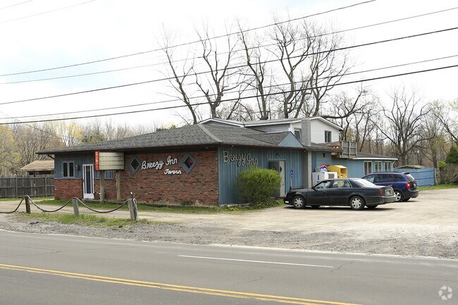
3964 E Center St
Cleveland-Elyria, OH
1 FICKINGER ALLOT
280450001800
Ashtabula
Restaurantbuilding
Ohio
B and X Area of moderate flood hazard, usually the area between the limits of the 100-year and 500-year floods.
1
2025
2.13 AC
2025
Ashtabula County
000200
Cleveland
5,324 SF
NEARBY LISTINGS FOR SALE OR LEASE
DEMOGRAPHICS near 3964 E Center St
1 mile
3 mile
5 mile
2025 Total Population
655
4,965
13,086
2030 Population
639
4,899
13,041
Pop Growth 2025-2030
(2.44%)
(1.33%)
(0.34%)
Average Age
45
45
44
2025 Total Households
267
2,106
5,470
HH Growth 2025-2030
(2.62%)
(1.28%)
(0.31%)
Median Household Inc
$75,893
$66,821
$57,913
Avg Household Size
2.30
2.20
2.20
2025 Avg HH Vehicles
2.00
2.00
2.00
Median Home Value
$173,451
$170,694
$155,414
Median Year Built
1970
1964
1957
Nearby Places
Map Layers
Map Styles
 Street
 Aerial
Layers
 Traffic
 Biking
Places
Listings with unknown addresses are not visible on the map
- Restaurants
- Banks
- Shops
- Fitness
- Groceries
PUBLIC TRANSPORTATION
AIRPORT
Erie International/Tom Ridge Field
Drive
Walk
Distance
Erie International/Tom Ridge Field
44 min
28.2 mi
Nearby Properties
Address
Land Use
TOTAL SIZE
Lot Size
Zoning
Address
Land Use
TOTAL SIZE
Lot Size
Zoning
Address
Land Use
TOTAL SIZE
Lot Size
Zoning
Address
Land Use
TOTAL SIZE
Lot Size
Zoning
0.09 AC
Address
Land Use
TOTAL SIZE
Lot Size
Zoning
202,939 SF
36.27 AC
Address
Land Use
TOTAL SIZE
Lot Size
Zoning
289,019 SF
34.01 AC
Address
Land Use
TOTAL SIZE
Lot Size
Zoning
Address
Land Use
TOTAL SIZE
Lot Size
Zoning
75,074 SF
5.61 AC
Address
Land Use
TOTAL SIZE
Lot Size
Zoning
98,857 SF
18.62 AC
Address
Land Use
TOTAL SIZE
Lot Size
Zoning
110,576 SF
17.91 AC
Address
Land Use
TOTAL SIZE
Lot Size
Zoning
4,576 SF
208.55 AC
Address
Land Use
TOTAL SIZE
Lot Size
Zoning
60,109 SF
10 AC
Address
Land Use
TOTAL SIZE
Lot Size
Zoning
6,136 SF
70.55 AC
Address
Land Use
TOTAL SIZE
Lot Size
Zoning
16,872 SF
45.37 AC
Address
Land Use
TOTAL SIZE
Lot Size
Zoning
1,057 SF
56.20 AC
Address
Land Use
TOTAL SIZE
Lot Size
Zoning
6,487 SF
10.40 AC
Address
Land Use
TOTAL SIZE
Lot Size
Zoning
16,960 SF
8.58 AC
Address
Land Use
TOTAL SIZE
Lot Size
Zoning
8,968 SF
6.99 AC
Address
Land Use
TOTAL SIZE
Lot Size
Zoning
16,972 SF
4 AC
Address
Land Use
TOTAL SIZE
Lot Size
Zoning
Address
Land Use
TOTAL SIZE
Lot Size
Zoning
3,228 SF
10.76 AC
Address
Land Use
TOTAL SIZE
Lot Size
Zoning
8,808 SF
29.75 AC
Address
Land Use
TOTAL SIZE
Lot Size
Zoning
6,188 SF
2.03 AC
Address
Land Use
TOTAL SIZE
Lot Size
Zoning
Address
Land Use
TOTAL SIZE
Lot Size
Zoning
17,150 SF
6.66 AC
Address
Land Use
TOTAL SIZE
Lot Size
Zoning
20,516 SF
2.44 AC
Address
Land Use
TOTAL SIZE
Lot Size
Zoning
13,782 SF
1.21 AC
Address
Land Use
TOTAL SIZE
Lot Size
Zoning
9,100 SF
1.55 AC
Address
Land Use
TOTAL SIZE
Lot Size
Zoning
1.75 AC
Address
Land Use
TOTAL SIZE
Lot Size
Zoning
12,097 SF
2.10 AC
Address
Land Use
TOTAL SIZE
Lot Size
Zoning
8,038 SF
54.47 AC
The World's #1 Commercial Real Estate Marketplace
Connect with us
© 2026 CoStar Group
The information above has been obtained from sources believed reliable. While we do not doubt its accuracy we have not verified it and make no guarantee, warranty or representation about it. It is your responsibility to independently confirm its accuracy and completeness. Any projections, opinions, assumptions, or estimates used are for example only and do not represent the current or future performance of the property. The value of this transaction to you depends on tax and other factors which should be evaluated by your tax, financial, and legal advisors. You and your advisors should conduct a careful, independent investigation of the property to determine to your satisfaction the suitability of the property for your needs.