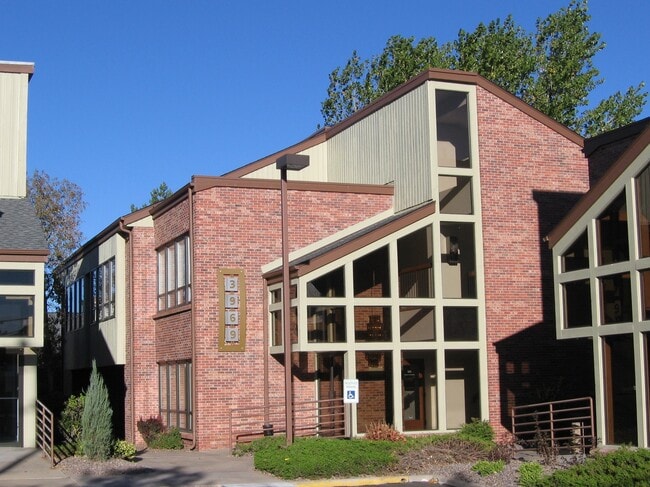
Property Record
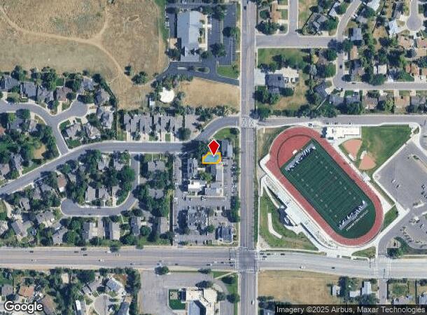
3969 E Arapahoe Rd, Centennial, CO 80122
This Property Is For Sale
NEARBY LISTINGS FOR SALE OR LEASE
Property Detail
3969 E Arapahoe Rd
Denver-Aurora-Centennial, CO
Strawberry Hill Office Park Condos 1St A
2077-24-4-23-002
SUBDIVISIONCD 059966 SUBDIVISIONNAME STRAWBERRY HILL OFFICE PARK CONDOS 1ST AMEND & RES BLOCK 000 LOT 002 UNIT 2 AS PER CONDO DECLARATION RECORDED ON RECEPTION #B7155943 STRAWBERRY HILL OFFICE PARK CONDOMINIUMS 1ST AMENDED & RESTATED
Commercialcondominium
Arapahoe
X
Colorado
08005C0452L
2
2024
0.12 AC
2025
Arapahoe Rd
005614
Denver
5,798 SF
DEMOGRAPHICS near 3969 E Arapahoe Rd
1 Mile
3 Mile
5 Mile
2024 Total Population
12,769
93,382
292,859
2029 Population
12,659
94,368
304,379
Pop Growth 2024-2029
(0.86%)
+ 1.06%
+ 3.93%
Average Age
44
42
41
2024 Total Households
5,024
37,536
124,228
HH Growth 2024-2029
(0.92%)
+ 1.20%
+ 3.83%
Median Household Inc
$121,052
$117,821
$105,274
Avg Household Size
2.50
2.40
2.30
2024 Avg HH Vehicles
2.00
2.00
2.00
Median Home Value
$567,312
$680,561
$653,850
Median Year Built
1972
1980
1984
Nearby Places
Map Layers
Map Styles
 Street
 Aerial
- Restaurants
- Banks
- Shops
- Fitness
- Groceries
PUBLIC TRANSPORTATION
AIRPORT
Denver International
DRIVE
WALK
Distance
Denver International
41 min
31.7 mi
Nearby Properties
Address
Land Use
TOTAL SIZE
Lot Size
Zoning
Address
Land Use
TOTAL SIZE
Lot Size
Zoning
443,472 SF
7.88 AC
AMU
Address
Land Use
TOTAL SIZE
Lot Size
Zoning
481,147 SF
38.27 AC
Address
Land Use
TOTAL SIZE
Lot Size
Zoning
389,502 SF
2.32 AC
T-MU-30
Address
Land Use
TOTAL SIZE
Lot Size
Zoning
344,259 SF
5.18 AC
Address
Land Use
TOTAL SIZE
Lot Size
Zoning
92,346 SF
4.22 AC
Address
Land Use
TOTAL SIZE
Lot Size
Zoning
331,620 SF
2.03 AC
T-MU-30
Address
Land Use
TOTAL SIZE
Lot Size
Zoning
313,812 SF
5.24 AC
GMC
Address
Land Use
TOTAL SIZE
Lot Size
Zoning
1,666,986 SF
11.12 AC
Address
Land Use
TOTAL SIZE
Lot Size
Zoning
470,605 SF
13.68 AC
B-8
Address
Land Use
TOTAL SIZE
Lot Size
Zoning
207,637 SF
28.17 AC
PDU
Address
Land Use
TOTAL SIZE
Lot Size
Zoning
252,760 SF
3.63 AC
Address
Land Use
TOTAL SIZE
Lot Size
Zoning
959,756 SF
5.52 AC
PUD
Address
Land Use
TOTAL SIZE
Lot Size
Zoning
453,595 SF
26.08 AC
PUD
Address
Land Use
TOTAL SIZE
Lot Size
Zoning
249,331 SF
4.93 AC
B-8
Address
Land Use
TOTAL SIZE
Lot Size
Zoning
186,993 SF
16.22 AC
Address
Land Use
TOTAL SIZE
Lot Size
Zoning
129,234 SF
0.95 AC
T-MU-30
Address
Land Use
TOTAL SIZE
Lot Size
Zoning
206,632 SF
33.68 AC
Address
Land Use
TOTAL SIZE
Lot Size
Zoning
585,091 SF
5.42 AC
PUD
Address
Land Use
TOTAL SIZE
Lot Size
Zoning
413,033 SF
4.33 AC
Address
Land Use
TOTAL SIZE
Lot Size
Zoning
332,114 SF
3.24 AC
GTC
Address
Land Use
TOTAL SIZE
Lot Size
Zoning
546,774 SF
8.81 AC
PUD
Address
Land Use
TOTAL SIZE
Lot Size
Zoning
250,402 SF
21 AC
Address
Land Use
TOTAL SIZE
Lot Size
Zoning
441,456 SF
21.82 AC
B-4
Address
Land Use
TOTAL SIZE
Lot Size
Zoning
395,438 SF
6.49 AC
AMU
Address
Land Use
TOTAL SIZE
Lot Size
Zoning
130,781 SF
3.26 AC
T-MU
Address
Land Use
TOTAL SIZE
Lot Size
Zoning
428,811 SF
8.73 AC
PUD
Address
Land Use
TOTAL SIZE
Lot Size
Zoning
71,984 SF
2.42 AC
B-4
Address
Land Use
TOTAL SIZE
Lot Size
Zoning
399,959 SF
18.07 AC
PUD
Address
Land Use
TOTAL SIZE
Lot Size
Zoning
789,305 SF
8.79 AC
PUD
Address
Land Use
TOTAL SIZE
Lot Size
Zoning
329,937 SF
35.07 AC
PUD
The World's #1 Commercial Real Estate Marketplace
Connect with us
© 2026 CoStar Group
The information above has been obtained from sources believed reliable. While we do not doubt its accuracy we have not verified it and make no guarantee, warranty or representation about it. It is your responsibility to independently confirm its accuracy and completeness. Any projections, opinions, assumptions, or estimates used are for example only and do not represent the current or future performance of the property. The value of this transaction to you depends on tax and other factors which should be evaluated by your tax, financial, and legal advisors. You and your advisors should conduct a careful, independent investigation of the property to determine to your satisfaction the suitability of the property for your needs.