Property Record
397 Fm/369 Cr, Taylor, TX 76574
Save to a Folder
{{folder.Name}}
{{folder.ListingIds.length}} Properties
{{folder.ListingIds.length}} Property
Create a New Folder
Property Detail
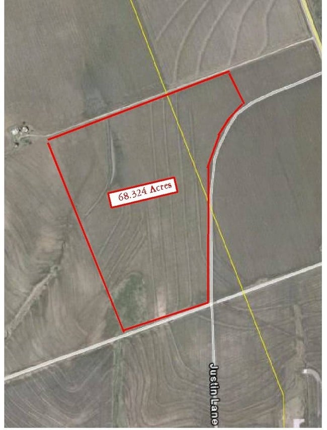
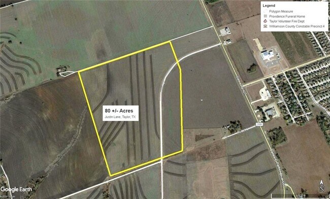
397 Fm/369 Cr
Austin-Round Rock-San Marcos, TX
AW0496 AW0496 - PHARRASS, S. SUR., ACRES 8.723
R019617
WILLIAMSON
Farms
Texas
B and X Area of moderate flood hazard, usually the area between the limits of the 100-year and 500-year floods.
58.46 AC
2024
Georgetown
2025
Austin
021203
NEARBY LISTINGS FOR SALE OR LEASE
DEMOGRAPHICS near 397 Fm/369 Cr
1 mile
3 mile
5 mile
2025 Total Population
2,376
18,562
22,171
2030 Population
2,749
21,237
25,438
Pop Growth 2025-2030
+ 15.70%
+ 14.41%
+ 14.74%
Average Age
41
40
40
2025 Total Households
871
6,954
8,270
HH Growth 2025-2030
+ 16.19%
+ 14.88%
+ 15.19%
Median Household Inc
$104,345
$71,227
$74,055
Avg Household Size
2.70
2.60
2.60
2025 Avg HH Vehicles
2.00
2.00
2.00
Median Home Value
$279,319
$320,453
$340,324
Median Year Built
2001
1983
1986
Nearby Places
Map Layers
Map Styles
 Street
 Aerial
Layers
 Traffic
 Biking
Places
Listings with unknown addresses are not visible on the map
- Restaurants
- Banks
- Shops
- Fitness
- Groceries
PUBLIC TRANSPORTATION
COMMUTER RAIL
Taylor Amtrak (Texas Eagle - Amtrak)
Drive
Walk
Distance
Taylor Amtrak (Texas Eagle - Amtrak)
7 min
3.5 mi
AIRPORT
Austin-Bergstrom International
Drive
Walk
Distance
Austin-Bergstrom International
54 min
41.4 mi
Freight Ports
Calhoun Port
Drive
Walk
Distance
Calhoun Port
214 min
184.4 mi
SALE & LEASE HISTORY
LISTING DATE
SALE/LEASE

Feb 11, 2021
For Sale
Feb 07, 2020
For Sale
Nearby Properties
Address
Land Use
TOTAL SIZE
Lot Size
Zoning
Address
Land Use
TOTAL SIZE
Lot Size
Zoning
1,213.97 AC
Address
Land Use
TOTAL SIZE
Lot Size
Zoning
1,213.97 AC
Address
Land Use
TOTAL SIZE
Lot Size
Zoning
52,527 SF
1,213.97 AC
Address
Land Use
TOTAL SIZE
Lot Size
Zoning
5,060,050 SF
354.33 AC
Address
Land Use
TOTAL SIZE
Lot Size
Zoning
208,704 SF
20.56 AC
2-M1
Address
Land Use
TOTAL SIZE
Lot Size
Zoning
46.70 AC
Address
Land Use
TOTAL SIZE
Lot Size
Zoning
205,355 SF
13.24 AC
Address
Land Use
TOTAL SIZE
Lot Size
Zoning
Address
Land Use
TOTAL SIZE
Lot Size
Zoning
69,997 SF
12.30 AC
3-B1
Address
Land Use
TOTAL SIZE
Lot Size
Zoning
192 SF
102.19 AC
Address
Land Use
TOTAL SIZE
Lot Size
Zoning
311,017 SF
39.81 AC
Address
Land Use
TOTAL SIZE
Lot Size
Zoning
133,666 SF
64.51 AC
2-M1
Address
Land Use
TOTAL SIZE
Lot Size
Zoning
58.91 AC
Address
Land Use
TOTAL SIZE
Lot Size
Zoning
68,657 SF
117.84 AC
2-M1
Address
Land Use
TOTAL SIZE
Lot Size
Zoning
Address
Land Use
TOTAL SIZE
Lot Size
Zoning
126,732 SF
9.52 AC
Address
Land Use
TOTAL SIZE
Lot Size
Zoning
94,210 SF
17.42 AC
3-B1
Address
Land Use
TOTAL SIZE
Lot Size
Zoning
152,302 SF
17.38 AC
3-B1
Address
Land Use
TOTAL SIZE
Lot Size
Zoning
83,300 SF
10.35 AC
Address
Land Use
TOTAL SIZE
Lot Size
Zoning
60,000 SF
15.74 AC
Address
Land Use
TOTAL SIZE
Lot Size
Zoning
59.01 AC
Address
Land Use
TOTAL SIZE
Lot Size
Zoning
42.43 AC
Address
Land Use
TOTAL SIZE
Lot Size
Zoning
72,164 SF
3.97 AC
Address
Land Use
TOTAL SIZE
Lot Size
Zoning
625 SF
51.85 AC
Address
Land Use
TOTAL SIZE
Lot Size
Zoning
72,094 SF
4.97 AC
Address
Land Use
TOTAL SIZE
Lot Size
Zoning
15.72 AC
Address
Land Use
TOTAL SIZE
Lot Size
Zoning
39,913 SF
1.54 AC
1-B3
Address
Land Use
TOTAL SIZE
Lot Size
Zoning
18.56 AC
Address
Land Use
TOTAL SIZE
Lot Size
Zoning
46,344 SF
4.05 AC
Address
Land Use
TOTAL SIZE
Lot Size
Zoning
46,344 SF
4.05 AC
The World's #1 Commercial Real Estate Marketplace
Connect with us
© 2026 CoStar Group
The information above has been obtained from sources believed reliable. While we do not doubt its accuracy we have not verified it and make no guarantee, warranty or representation about it. It is your responsibility to independently confirm its accuracy and completeness. Any projections, opinions, assumptions, or estimates used are for example only and do not represent the current or future performance of the property. The value of this transaction to you depends on tax and other factors which should be evaluated by your tax, financial, and legal advisors. You and your advisors should conduct a careful, independent investigation of the property to determine to your satisfaction the suitability of the property for your needs.