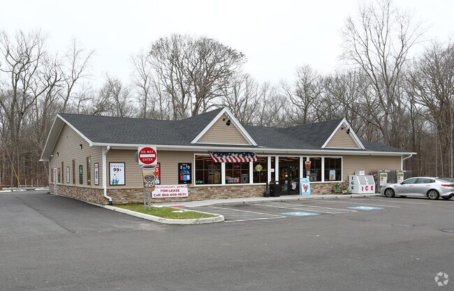
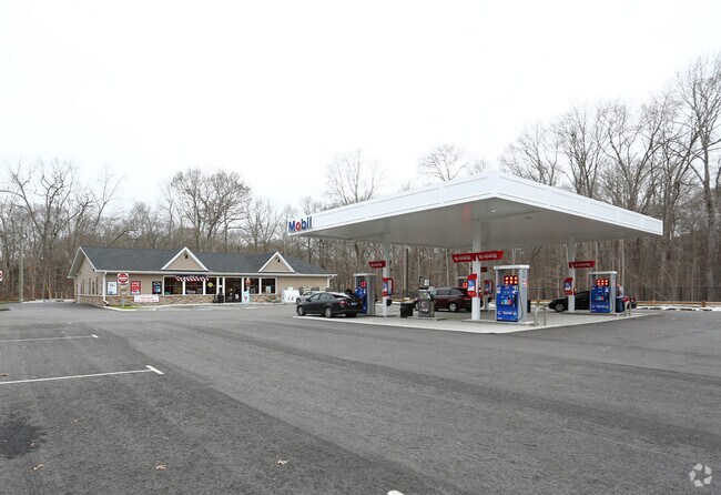
Property Record
397 Route 2, Preston, CT 06365

Property Detail
397 Route 2
PRES-000240-000002-000397
Southeastern Ct
Storebuilding
Connecticut
RC
397
B and X Area of moderate flood hazard, usually the area between the limits of the 100-year and 500-year floods.
2 AC
2024
NE New London/Norwich
2025
Hartford
700100
Norwich-New London-Willimantic, CT
5,040 SF
NEARBY LISTINGS FOR SALE OR LEASE
-
-
View all Preston listings for sale on LoopNet.com
DEMOGRAPHICS near 397 Route 2
1 mile
3 mile
5 mile
2025 Total Population
773
5,766
23,268
2030 Population
783
5,878
23,402
Pop Growth 2025-2030
+ 1.29%
+ 1.94%
+ 0.58%
Average Age
43
42
41
2025 Total Households
283
2,162
9,125
HH Growth 2025-2030
+ 1.06%
+ 1.76%
+ 0.53%
Median Household Inc
$138,141
$114,578
$91,004
Avg Household Size
2.70
2.60
2.50
2025 Avg HH Vehicles
2.00
2.00
2.00
Median Home Value
$350,955
$337,317
$307,754
Median Year Built
1968
1970
1965
Nearby Places
Map Layers
Map Styles
 Street
 Aerial
Layers
 Traffic
 Biking
Places
Listings with unknown addresses are not visible on the map
- Restaurants
- Banks
- Shops
- Fitness
- Groceries
PUBLIC TRANSPORTATION
AIRPORT
Rhode Island Tf Green International
Drive
Walk
Distance
Rhode Island Tf Green International
63 min
45.2 mi
Freight Ports
Port of Davisville, RI
Drive
Walk
Distance
Port of Davisville, RI
64 min
45.4 mi
Nearby Properties
Address
Land Use
TOTAL SIZE
Lot Size
Zoning
Address
Land Use
TOTAL SIZE
Lot Size
Zoning
393.02 AC
R80
Address
Land Use
TOTAL SIZE
Lot Size
Zoning
20.51 AC
RCCD
Address
Land Use
TOTAL SIZE
Lot Size
Zoning
912.10 AC
C
Address
Land Use
TOTAL SIZE
Lot Size
Zoning
105,680 SF
8.50 AC
RC
Address
Land Use
TOTAL SIZE
Lot Size
Zoning
10 AC
R60
Address
Land Use
TOTAL SIZE
Lot Size
Zoning
35.50 AC
RCCD
Address
Land Use
TOTAL SIZE
Lot Size
Zoning
39,350 SF
10 AC
RC
Address
Land Use
TOTAL SIZE
Lot Size
Zoning
12.49 AC
RCCD
Address
Land Use
TOTAL SIZE
Lot Size
Zoning
7.68 AC
RCCD
Address
Land Use
TOTAL SIZE
Lot Size
Zoning
15.38 AC
R40
Address
Land Use
TOTAL SIZE
Lot Size
Zoning
5.76 AC
Address
Land Use
TOTAL SIZE
Lot Size
Zoning
1,023 SF
17.10 AC
R-60
Address
Land Use
TOTAL SIZE
Lot Size
Zoning
6.70 AC
I
Address
Land Use
TOTAL SIZE
Lot Size
Zoning
61.01 AC
R-60
Address
Land Use
TOTAL SIZE
Lot Size
Zoning
3 AC
C-1
Address
Land Use
TOTAL SIZE
Lot Size
Zoning
9,440 SF
49.61 AC
R60
Address
Land Use
TOTAL SIZE
Lot Size
Zoning
38.24 AC
RC
Address
Land Use
TOTAL SIZE
Lot Size
Zoning
147.21 AC
R80
Address
Land Use
TOTAL SIZE
Lot Size
Zoning
8,872 SF
1.40 AC
R-40
Address
Land Use
TOTAL SIZE
Lot Size
Zoning
5,292 SF
25.86 AC
RC
Address
Land Use
TOTAL SIZE
Lot Size
Zoning
2.64 AC
R-40
Address
Land Use
TOTAL SIZE
Lot Size
Zoning
15.19 AC
R-40
Address
Land Use
TOTAL SIZE
Lot Size
Zoning
5,151 SF
4.35 AC
R60
Address
Land Use
TOTAL SIZE
Lot Size
Zoning
4,996 SF
2.36 AC
RC
Address
Land Use
TOTAL SIZE
Lot Size
Zoning
5,130 SF
1 AC
R60
Address
Land Use
TOTAL SIZE
Lot Size
Zoning
1,559 SF
57.66 AC
RCCD
Address
Land Use
TOTAL SIZE
Lot Size
Zoning
1,444 SF
87.14 AC
R60
Address
Land Use
TOTAL SIZE
Lot Size
Zoning
54.20 AC
R60
Address
Land Use
TOTAL SIZE
Lot Size
Zoning
3,696 SF
0.89 AC
C-1
The World's #1 Commercial Real Estate Marketplace
Connect with us
© 2026 CoStar Group
The information above has been obtained from sources believed reliable. While we do not doubt its accuracy we have not verified it and make no guarantee, warranty or representation about it. It is your responsibility to independently confirm its accuracy and completeness. Any projections, opinions, assumptions, or estimates used are for example only and do not represent the current or future performance of the property. The value of this transaction to you depends on tax and other factors which should be evaluated by your tax, financial, and legal advisors. You and your advisors should conduct a careful, independent investigation of the property to determine to your satisfaction the suitability of the property for your needs.