Property Record
3972 S Us Highway 45, Oshkosh, WI 54902
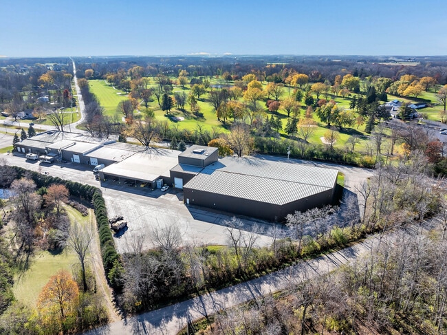
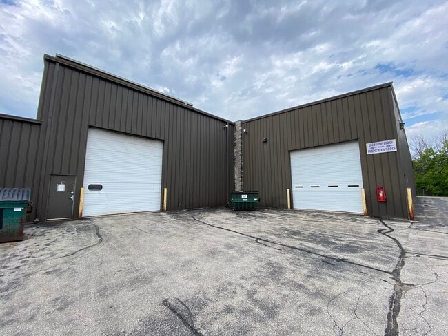
This Property Is For Sale
NEARBY LISTINGS FOR SALE OR LEASE
-
-
View all Oshkosh listings for sale on LoopNet.com
Property Detail
3972 S Us Highway 45
Oshkosh-Neenah, WI
PT NE NE COM NE LN HWY & E SEC LN NW ON HWY 204.5 FT N46DG56E 150 FT SE PAR TO HWY TO E SEC LN S TO POB SEC 12T17NR16E ALSO PT GOVT LOT 1 COM INTERSEC W SEC LN & NE L HWY SE 60.5 FT N46DG56W 150 FT NW
004-023308
Winnebago
Industrialgeneral
Wisconsin
X
1
55039C0100F
4.40 AC
2024
Appleton/Oshkosh
2024
Other Market Areas
001900
DEMOGRAPHICS near 3972 S Us Highway 45
1 Mile
3 Mile
5 Mile
2024 Total Population
1,364
7,229
47,088
2029 Population
1,379
7,252
47,242
Pop Growth 2024-2029
+ 1.10%
+ 0.32%
+ 0.33%
Average Age
43
42
38
2024 Total Households
609
3,266
20,142
HH Growth 2024-2029
+ 0.99%
+ 0.12%
+ 0.39%
Median Household Inc
$67,138
$66,949
$57,442
Avg Household Size
2.20
2.20
2.10
2024 Avg HH Vehicles
2.00
2.00
2.00
Median Home Value
$298,420
$179,839
$156,708
Median Year Built
1993
1954
1960
Nearby Places
Map Layers
Map Styles
 Street
 Aerial
- Restaurants
- Banks
- Shops
- Fitness
- Groceries
PUBLIC TRANSPORTATION
AIRPORT
Appleton International
DRIVE
WALK
Distance
Appleton International
35 min
24.4 mi
Freight Ports
Port Milwaukee
DRIVE
WALK
Distance
Port Milwaukee
106 min
84.7 mi
Nearby Properties
Address
Land Use
TOTAL SIZE
Lot Size
Zoning
Address
Land Use
TOTAL SIZE
Lot Size
Zoning
7.74 AC
Address
Land Use
TOTAL SIZE
Lot Size
Zoning
570,585 SF
81.26 AC
M2
Address
Land Use
TOTAL SIZE
Lot Size
Zoning
18.38 AC
UIPD
Address
Land Use
TOTAL SIZE
Lot Size
Zoning
110,200 SF
14.77 AC
MR-12-PD
Address
Land Use
TOTAL SIZE
Lot Size
Zoning
238,238 SF
22.60 AC
M3
Address
Land Use
TOTAL SIZE
Lot Size
Zoning
117,892 SF
7.36 AC
MR-20
Address
Land Use
TOTAL SIZE
Lot Size
Zoning
58,465 SF
43.67 AC
M3
Address
Land Use
TOTAL SIZE
Lot Size
Zoning
91,288 SF
7.29 AC
MR-12
Address
Land Use
TOTAL SIZE
Lot Size
Zoning
254,308 SF
14.44 AC
M2
Address
Land Use
TOTAL SIZE
Lot Size
Zoning
54,672 SF
6.14 AC
NMU
Address
Land Use
TOTAL SIZE
Lot Size
Zoning
112,099 SF
8.64 AC
UMU
Address
Land Use
TOTAL SIZE
Lot Size
Zoning
31,298 SF
0.72 AC
M3
Address
Land Use
TOTAL SIZE
Lot Size
Zoning
96,967 SF
3.42 AC
M2
Address
Land Use
TOTAL SIZE
Lot Size
Zoning
119,046 SF
5.45 AC
M3
Address
Land Use
TOTAL SIZE
Lot Size
Zoning
117,249 SF
22.05 AC
M3
Address
Land Use
TOTAL SIZE
Lot Size
Zoning
26,852 SF
7.28 AC
IPD
Address
Land Use
TOTAL SIZE
Lot Size
Zoning
25,879 SF
29.11 AC
C2
Address
Land Use
TOTAL SIZE
Lot Size
Zoning
77,575 SF
4.75 AC
M3
Address
Land Use
TOTAL SIZE
Lot Size
Zoning
97,500 SF
9.95 AC
M3
Address
Land Use
TOTAL SIZE
Lot Size
Zoning
18.99 AC
HI
Address
Land Use
TOTAL SIZE
Lot Size
Zoning
61,454 SF
6.49 AC
M3
Address
Land Use
TOTAL SIZE
Lot Size
Zoning
61,704 SF
1.46 AC
M3
Address
Land Use
TOTAL SIZE
Lot Size
Zoning
6.42 AC
HI
Address
Land Use
TOTAL SIZE
Lot Size
Zoning
55,886 SF
4.08 AC
M3
Address
Land Use
TOTAL SIZE
Lot Size
Zoning
91,000 SF
9.32 AC
M2
Address
Land Use
TOTAL SIZE
Lot Size
Zoning
73,060 SF
29.17 AC
M2
Address
Land Use
TOTAL SIZE
Lot Size
Zoning
27,382 SF
0.63 AC
M3
Address
Land Use
TOTAL SIZE
Lot Size
Zoning
91,352 SF
12 AC
M3
Address
Land Use
TOTAL SIZE
Lot Size
Zoning
45,762 SF
5.83 AC
HI
Address
Land Use
TOTAL SIZE
Lot Size
Zoning
36.51 AC
P1
The World's #1 Commercial Real Estate Marketplace
Connect with us
© 2026 CoStar Group
The information above has been obtained from sources believed reliable. While we do not doubt its accuracy we have not verified it and make no guarantee, warranty or representation about it. It is your responsibility to independently confirm its accuracy and completeness. Any projections, opinions, assumptions, or estimates used are for example only and do not represent the current or future performance of the property. The value of this transaction to you depends on tax and other factors which should be evaluated by your tax, financial, and legal advisors. You and your advisors should conduct a careful, independent investigation of the property to determine to your satisfaction the suitability of the property for your needs.