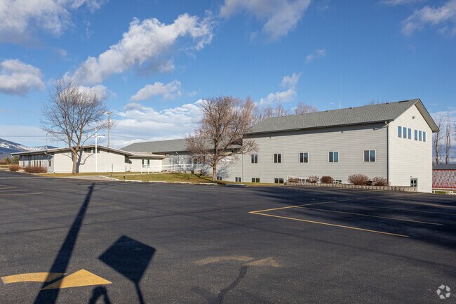
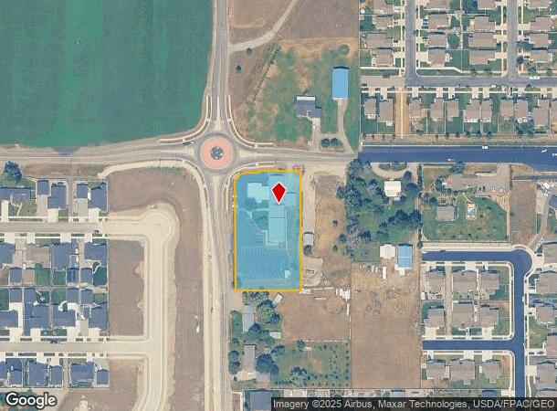
Property Record
3974 N Chase Rd, Post Falls, ID 83854
NEARBY LISTINGS FOR SALE OR LEASE
-
-
View all Post Falls listings for sale on LoopNet.com
Property Detail
3974 N Chase Rd
51N05W273210
Nw-Nw
Realpropertynec
TAX#8747 EX RW [IN NW-NW] 2751N05W
X
Kootenai
16055C0380E
Idaho
2025
1.49 AC
2025
Post Falls
000402
Coeur D'Alene
10,483 SF
Coeur d'Alene, ID
DEMOGRAPHICS near 3974 N Chase Rd
1 Mile
3 Mile
5 Mile
2024 Total Population
7,041
37,205
63,108
2029 Population
8,446
44,395
75,288
Pop Growth 2024-2029
+ 19.95%
+ 19.33%
+ 19.30%
Average Age
37
38
39
2024 Total Households
2,528
13,871
23,786
HH Growth 2024-2029
+ 19.54%
+ 18.97%
+ 18.96%
Median Household Inc
$87,394
$72,121
$68,935
Avg Household Size
2.70
2.60
2.60
2024 Avg HH Vehicles
2.00
2.00
2.00
Median Home Value
$424,103
$392,816
$417,284
Median Year Built
2009
2004
2002
Nearby Places
Map Layers
Map Styles
 Street
 Aerial
- Restaurants
- Banks
- Shops
- Fitness
- Groceries
PUBLIC TRANSPORTATION
AIRPORT
Spokane International
DRIVE
WALK
Distance
Spokane International
43 min
31.5 mi
Freight Ports
Port of Everett
DRIVE
WALK
Distance
Port of Everett
370 min
327.1 mi
Nearby Properties
Address
Land Use
TOTAL SIZE
Lot Size
Zoning
Address
Land Use
TOTAL SIZE
Lot Size
Zoning
135,646 SF
18.40 AC
Address
Land Use
TOTAL SIZE
Lot Size
Zoning
320,505 SF
60.51 AC
Address
Land Use
TOTAL SIZE
Lot Size
Zoning
89,184 SF
8.69 AC
Address
Land Use
TOTAL SIZE
Lot Size
Zoning
88,780 SF
8.23 AC
Address
Land Use
TOTAL SIZE
Lot Size
Zoning
104,852 SF
5.70 AC
Address
Land Use
TOTAL SIZE
Lot Size
Zoning
42,636 SF
24.81 AC
Address
Land Use
TOTAL SIZE
Lot Size
Zoning
94,960 SF
7.45 AC
Address
Land Use
TOTAL SIZE
Lot Size
Zoning
12,600 SF
29.04 AC
Address
Land Use
TOTAL SIZE
Lot Size
Zoning
57,936 SF
7.88 AC
Address
Land Use
TOTAL SIZE
Lot Size
Zoning
465,080 SF
31.43 AC
Address
Land Use
TOTAL SIZE
Lot Size
Zoning
110,520 SF
4.68 AC
Address
Land Use
TOTAL SIZE
Lot Size
Zoning
112,154 SF
4.61 AC
Address
Land Use
TOTAL SIZE
Lot Size
Zoning
94,193 SF
18.10 AC
AGSUB
Address
Land Use
TOTAL SIZE
Lot Size
Zoning
82,700 SF
21 AC
Address
Land Use
TOTAL SIZE
Lot Size
Zoning
106,656 SF
4.60 AC
Address
Land Use
TOTAL SIZE
Lot Size
Zoning
108,524 SF
20.34 AC
Address
Land Use
TOTAL SIZE
Lot Size
Zoning
16,185 SF
60.19 AC
Address
Land Use
TOTAL SIZE
Lot Size
Zoning
60,246 SF
3.67 AC
Address
Land Use
TOTAL SIZE
Lot Size
Zoning
59,039 SF
4.17 AC
Address
Land Use
TOTAL SIZE
Lot Size
Zoning
56,150 SF
1.56 AC
Address
Land Use
TOTAL SIZE
Lot Size
Zoning
61,536 SF
4.40 AC
Address
Land Use
TOTAL SIZE
Lot Size
Zoning
49,802 SF
9.86 AC
Address
Land Use
TOTAL SIZE
Lot Size
Zoning
108,441 SF
10.01 AC
COM
Address
Land Use
TOTAL SIZE
Lot Size
Zoning
67,104 SF
4.03 AC
Address
Land Use
TOTAL SIZE
Lot Size
Zoning
29,977 SF
2.61 AC
Address
Land Use
TOTAL SIZE
Lot Size
Zoning
34,688 SF
5.50 AC
Address
Land Use
TOTAL SIZE
Lot Size
Zoning
46,671 SF
8.29 AC
Address
Land Use
TOTAL SIZE
Lot Size
Zoning
116,010 SF
6 AC
Address
Land Use
TOTAL SIZE
Lot Size
Zoning
108,819 SF
9.66 AC
Address
Land Use
TOTAL SIZE
Lot Size
Zoning
16,914 SF
5 AC
The World's #1 Commercial Real Estate Marketplace
Connect with us
© 2026 CoStar Group
The information above has been obtained from sources believed reliable. While we do not doubt its accuracy we have not verified it and make no guarantee, warranty or representation about it. It is your responsibility to independently confirm its accuracy and completeness. Any projections, opinions, assumptions, or estimates used are for example only and do not represent the current or future performance of the property. The value of this transaction to you depends on tax and other factors which should be evaluated by your tax, financial, and legal advisors. You and your advisors should conduct a careful, independent investigation of the property to determine to your satisfaction the suitability of the property for your needs.