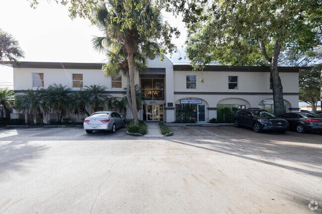
Property Record
3975 20Th St, Vero Beach, FL 32960


Current Lease Availabilities
NEARBY LISTINGS FOR SALE OR LEASE
Property Detail
3975 20Th St
Sebastian-Vero Beach, FL
Sunnyside Park
33-39-03-00026-0010-00001.0
SUNNYSIDE PARK SUB BLK 1 LOTS 1, 2, 3 & 4 PBI 1-7
Officebuilding
Indian River
X
Florida
12061C0243H
1-4
2025
0.96 AC
2025
Fort Pierce/Port St Lucie
050101
Other Market Areas
12,631 SF
DEMOGRAPHICS near 3975 20Th St
1 Mile
3 Mile
5 Mile
2024 Total Population
7,432
51,131
101,092
2029 Population
8,215
57,007
113,411
Pop Growth 2024-2029
+ 10.54%
+ 11.49%
+ 12.19%
Average Age
44
46
50
2024 Total Households
3,040
22,532
46,137
HH Growth 2024-2029
+ 9.97%
+ 11.22%
+ 11.98%
Median Household Inc
$52,181
$54,240
$58,679
Avg Household Size
2.20
2.10
2.10
2024 Avg HH Vehicles
2.00
2.00
2.00
Median Home Value
$228,790
$245,146
$281,388
Median Year Built
1974
1984
1988
Nearby Places
Map Layers
Map Styles
 Street
 Aerial
- Restaurants
- Banks
- Shops
- Fitness
- Groceries
PUBLIC TRANSPORTATION
AIRPORT
Melbourne Orlando International
DRIVE
WALK
Distance
Melbourne Orlando International
57 min
40.6 mi
Nearby Properties
Address
Land Use
TOTAL SIZE
Lot Size
Zoning
Address
Land Use
TOTAL SIZE
Lot Size
Zoning
634,259 SF
53.45 AC
MED
Address
Land Use
TOTAL SIZE
Lot Size
Zoning
303,447 SF
26.90 AC
M
Address
Land Use
TOTAL SIZE
Lot Size
Zoning
571,211 SF
26.38 AC
RM-10
Address
Land Use
TOTAL SIZE
Lot Size
Zoning
302,878 SF
40 AC
INST
Address
Land Use
TOTAL SIZE
Lot Size
Zoning
39,873 SF
7.61 AC
GU
Address
Land Use
TOTAL SIZE
Lot Size
Zoning
2,133 SF
772.04 AC
ALI-A1
Address
Land Use
TOTAL SIZE
Lot Size
Zoning
46,567 SF
19.61 AC
CG
Address
Land Use
TOTAL SIZE
Lot Size
Zoning
204,713 SF
10.56 AC
PDMXD
Address
Land Use
TOTAL SIZE
Lot Size
Zoning
12,192 SF
40 AC
RS-6
Address
Land Use
TOTAL SIZE
Lot Size
Zoning
125,677 SF
2.17 AC
DTW
Address
Land Use
TOTAL SIZE
Lot Size
Zoning
49,513 SF
60.64 AC
ALI-MC
Address
Land Use
TOTAL SIZE
Lot Size
Zoning
408,898 SF
78.81 AC
CG
Address
Land Use
TOTAL SIZE
Lot Size
Zoning
241,529 SF
29.18 AC
RM-8
Address
Land Use
TOTAL SIZE
Lot Size
Zoning
106,904 SF
79.05 AC
M
Address
Land Use
TOTAL SIZE
Lot Size
Zoning
83,300 SF
84.34 AC
A-1
Address
Land Use
TOTAL SIZE
Lot Size
Zoning
153,530 SF
17.40 AC
CG
Address
Land Use
TOTAL SIZE
Lot Size
Zoning
313,820 SF
21.83 AC
RM-10 EX
Address
Land Use
TOTAL SIZE
Lot Size
Zoning
235,921 SF
28.80 AC
RM-8
Address
Land Use
TOTAL SIZE
Lot Size
Zoning
298,394 SF
14 AC
RM-6
Address
Land Use
TOTAL SIZE
Lot Size
Zoning
67,334 SF
9.63 AC
MED
Address
Land Use
TOTAL SIZE
Lot Size
Zoning
351 SF
11.09 AC
CG
Address
Land Use
TOTAL SIZE
Lot Size
Zoning
149,178 SF
10.72 AC
C-1B
Address
Land Use
TOTAL SIZE
Lot Size
Zoning
81,567 SF
35.55 AC
A-1
Address
Land Use
TOTAL SIZE
Lot Size
Zoning
206,738 SF
17.76 AC
PD
Address
Land Use
TOTAL SIZE
Lot Size
Zoning
69,942 SF
10.47 AC
MED
Address
Land Use
TOTAL SIZE
Lot Size
Zoning
180,092 SF
14.66 AC
RM-8
Address
Land Use
TOTAL SIZE
Lot Size
Zoning
102,808 SF
12.51 AC
CG
Address
Land Use
TOTAL SIZE
Lot Size
Zoning
91,904 SF
10 AC
CG
Address
Land Use
TOTAL SIZE
Lot Size
Zoning
2,232 SF
8.35 AC
C-1B
Address
Land Use
TOTAL SIZE
Lot Size
Zoning
150,160 SF
13.12 AC
PD
The World's #1 Commercial Real Estate Marketplace
Connect with us
© 2026 CoStar Group
The information above has been obtained from sources believed reliable. While we do not doubt its accuracy we have not verified it and make no guarantee, warranty or representation about it. It is your responsibility to independently confirm its accuracy and completeness. Any projections, opinions, assumptions, or estimates used are for example only and do not represent the current or future performance of the property. The value of this transaction to you depends on tax and other factors which should be evaluated by your tax, financial, and legal advisors. You and your advisors should conduct a careful, independent investigation of the property to determine to your satisfaction the suitability of the property for your needs.