Property Record
3975 Highway 82 W, Leland, MS 38756

Save to a Folder
{{folder.Name}}
{{folder.ListingIds.length}} Properties
{{folder.ListingIds.length}} Property
Create a New Folder
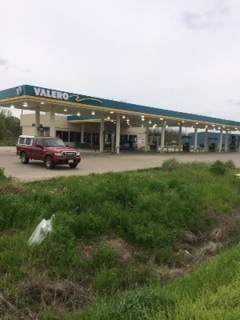
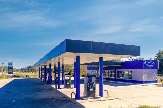
Property Detail
3975 Highway 82 W
248900000
TRACT IN NE1/4 NE1/4 OF NW1/4
Storebuilding
Washington
AE The base floodplain where base flood elevations are provided. AE Zones are now used on new format FIRMs instead of A1-A30 Zones.
Mississippi
2025
2.86 AC
2025
Vicksburg/Central Area
001500
Other Market Areas
3,375 SF
Greenville, MS
NEARBY LISTINGS FOR SALE OR LEASE
-
-
View all Leland listings for sale on LoopNet.com
DEMOGRAPHICS near 3975 Highway 82 W
1 mile
3 mile
5 mile
2025 Total Population
665
1,964
19,963
2030 Population
647
1,894
18,926
Pop Growth 2025-2030
(2.71%)
(3.56%)
(5.19%)
Average Age
39
39
40
2025 Total Households
262
778
7,851
HH Growth 2025-2030
(2.67%)
(3.73%)
(5.29%)
Median Household Inc
$43,749
$45,937
$40,355
Avg Household Size
2.50
2.50
2.40
2025 Avg HH Vehicles
2.00
2.00
2.00
Median Home Value
$99,999
$90,624
$86,514
Median Year Built
1981
1979
1970
Nearby Places
Map Layers
Map Styles
 Street
 Aerial
Layers
 Traffic
 Biking
Places
Listings with unknown addresses are not visible on the map
- Restaurants
- Banks
- Shops
- Fitness
- Groceries
SALE & LEASE HISTORY
LISTING DATE
SALE/LEASE

Sep 23, 2016
For Sale
Dec 03, 2024
For Sale
Aug 10, 2021
For Sale
Apr 28, 2022
For Sale
Apr 24, 2024
For Sale
Apr 13, 2021
For Sale
Nearby Properties
Address
Land Use
TOTAL SIZE
Lot Size
Zoning
Address
Land Use
TOTAL SIZE
Lot Size
Zoning
20,000 SF
4.34 AC
Address
Land Use
TOTAL SIZE
Lot Size
Zoning
13,640 SF
3 AC
Address
Land Use
TOTAL SIZE
Lot Size
Zoning
9,164 SF
1 AC
Address
Land Use
TOTAL SIZE
Lot Size
Zoning
3,564 SF
8.25 AC
Address
Land Use
TOTAL SIZE
Lot Size
Zoning
35,393 SF
1.36 AC
Address
Land Use
TOTAL SIZE
Lot Size
Zoning
3,604 SF
1.80 AC
Address
Land Use
TOTAL SIZE
Lot Size
Zoning
8,827 SF
1.30 AC
Address
Land Use
TOTAL SIZE
Lot Size
Zoning
80,500 SF
10.40 AC
Address
Land Use
TOTAL SIZE
Lot Size
Zoning
25,601 SF
1 AC
Address
Land Use
TOTAL SIZE
Lot Size
Zoning
38,728 SF
2.47 AC
Address
Land Use
TOTAL SIZE
Lot Size
Zoning
20,000 SF
3.40 AC
Address
Land Use
TOTAL SIZE
Lot Size
Zoning
6,027 SF
74.20 AC
Address
Land Use
TOTAL SIZE
Lot Size
Zoning
2,800 SF
5.91 AC
Address
Land Use
TOTAL SIZE
Lot Size
Zoning
7,266 SF
3.61 AC
Address
Land Use
TOTAL SIZE
Lot Size
Zoning
6,160 SF
0.93 AC
Address
Land Use
TOTAL SIZE
Lot Size
Zoning
16,576 SF
27.30 AC
Address
Land Use
TOTAL SIZE
Lot Size
Zoning
38,828 SF
4.60 AC
Address
Land Use
TOTAL SIZE
Lot Size
Zoning
2,500 SF
2.64 AC
Address
Land Use
TOTAL SIZE
Lot Size
Zoning
4,956 SF
2 AC
Address
Land Use
TOTAL SIZE
Lot Size
Zoning
4,764 SF
2.75 AC
Address
Land Use
TOTAL SIZE
Lot Size
Zoning
4,800 SF
2.75 AC
Address
Land Use
TOTAL SIZE
Lot Size
Zoning
2,412 SF
0.30 AC
Address
Land Use
TOTAL SIZE
Lot Size
Zoning
6,535 SF
1.15 AC
Address
Land Use
TOTAL SIZE
Lot Size
Zoning
16,428 SF
16.90 AC
Address
Land Use
TOTAL SIZE
Lot Size
Zoning
16,000 SF
6.43 AC
Address
Land Use
TOTAL SIZE
Lot Size
Zoning
22,560 SF
8.80 AC
Address
Land Use
TOTAL SIZE
Lot Size
Zoning
10,000 SF
12 AC
Address
Land Use
TOTAL SIZE
Lot Size
Zoning
3,744 SF
1 AC
Address
Land Use
TOTAL SIZE
Lot Size
Zoning
10.41 AC
The World's #1 Commercial Real Estate Marketplace
Connect with us
© 2026 CoStar Group
The information above has been obtained from sources believed reliable. While we do not doubt its accuracy we have not verified it and make no guarantee, warranty or representation about it. It is your responsibility to independently confirm its accuracy and completeness. Any projections, opinions, assumptions, or estimates used are for example only and do not represent the current or future performance of the property. The value of this transaction to you depends on tax and other factors which should be evaluated by your tax, financial, and legal advisors. You and your advisors should conduct a careful, independent investigation of the property to determine to your satisfaction the suitability of the property for your needs.