Property Record
3975 S Hametown Rd, Norton, OH 44203
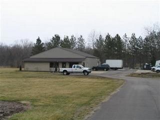

Property Detail
3975 S Hametown Rd
Akron, OH
LOT 43 E OF HAMETOWN RD N OF N OF GREENWICH RD 2.6293A
46-08201
Summit
Commercialnec
Ohio
B and X Area of moderate flood hazard, usually the area between the limits of the 100-year and 500-year floods.
43
2025
2.63 AC
2026
Akron
532003
Cleveland
4,100 SF
NEARBY LISTINGS FOR SALE OR LEASE
DEMOGRAPHICS near 3975 S Hametown Rd
1 mile
3 mile
5 mile
2025 Total Population
1,406
28,546
78,276
2030 Population
1,428
28,584
78,508
Pop Growth 2025-2030
+ 1.56%
+ 0.13%
+ 0.30%
Average Age
44
42
42
2025 Total Households
573
11,741
32,425
HH Growth 2025-2030
+ 1.57%
+ 0.10%
+ 0.26%
Median Household Inc
$84,091
$71,767
$66,068
Avg Household Size
2.40
2.40
2.40
2025 Avg HH Vehicles
2.00
2.00
2.00
Median Home Value
$200,272
$191,055
$195,435
Median Year Built
1963
1962
1966
Nearby Places
Map Layers
Map Styles
 Street
 Aerial
Layers
 Traffic
 Biking
Places
Listings with unknown addresses are not visible on the map
- Restaurants
- Banks
- Shops
- Fitness
- Groceries
PUBLIC TRANSPORTATION
AIRPORT
Akron-Canton Regional
Drive
Walk
Distance
Akron-Canton Regional
29 min
19.3 mi
Cleveland-Hopkins International
Drive
Walk
Distance
Cleveland-Hopkins International
55 min
36.8 mi
Freight Ports
Port of Toledo
Drive
Walk
Distance
Port of Toledo
158 min
133.6 mi
Nearby Properties
Address
Land Use
TOTAL SIZE
Lot Size
Zoning
Address
Land Use
TOTAL SIZE
Lot Size
Zoning
73,550 SF
100.93 AC
Address
Land Use
TOTAL SIZE
Lot Size
Zoning
148,344 SF
40.32 AC
Address
Land Use
TOTAL SIZE
Lot Size
Zoning
Address
Land Use
TOTAL SIZE
Lot Size
Zoning
Address
Land Use
TOTAL SIZE
Lot Size
Zoning
3,832 SF
56.46 AC
Address
Land Use
TOTAL SIZE
Lot Size
Zoning
Address
Land Use
TOTAL SIZE
Lot Size
Zoning
Address
Land Use
TOTAL SIZE
Lot Size
Zoning
87,486 SF
7.25 AC
Address
Land Use
TOTAL SIZE
Lot Size
Zoning
204,276 SF
28.95 AC
Address
Land Use
TOTAL SIZE
Lot Size
Zoning
54,899 SF
11.04 AC
Address
Land Use
TOTAL SIZE
Lot Size
Zoning
29,161 SF
15.94 AC
Address
Land Use
TOTAL SIZE
Lot Size
Zoning
29,256 SF
25.13 AC
Address
Land Use
TOTAL SIZE
Lot Size
Zoning
Address
Land Use
TOTAL SIZE
Lot Size
Zoning
99,931 SF
16.82 AC
Address
Land Use
TOTAL SIZE
Lot Size
Zoning
253,690 SF
12.18 AC
Address
Land Use
TOTAL SIZE
Lot Size
Zoning
138,251 SF
15.17 AC
Address
Land Use
TOTAL SIZE
Lot Size
Zoning
448.72 AC
Address
Land Use
TOTAL SIZE
Lot Size
Zoning
43,727 SF
97.90 AC
Address
Land Use
TOTAL SIZE
Lot Size
Zoning
17.74 AC
Address
Land Use
TOTAL SIZE
Lot Size
Zoning
15,486 SF
4.25 AC
Address
Land Use
TOTAL SIZE
Lot Size
Zoning
91,962 SF
15.90 AC
Address
Land Use
TOTAL SIZE
Lot Size
Zoning
121,395 SF
10.63 AC
Address
Land Use
TOTAL SIZE
Lot Size
Zoning
15,439 SF
3.27 AC
Address
Land Use
TOTAL SIZE
Lot Size
Zoning
832 SF
16.75 AC
Address
Land Use
TOTAL SIZE
Lot Size
Zoning
17.87 AC
Address
Land Use
TOTAL SIZE
Lot Size
Zoning
144,162 SF
17.39 AC
Address
Land Use
TOTAL SIZE
Lot Size
Zoning
87,953 SF
8.78 AC
Address
Land Use
TOTAL SIZE
Lot Size
Zoning
45,463 SF
1.64 AC
Address
Land Use
TOTAL SIZE
Lot Size
Zoning
75,284 SF
5 AC
Address
Land Use
TOTAL SIZE
Lot Size
Zoning
23,145 SF
31.40 AC
The World's #1 Commercial Real Estate Marketplace
Connect with us
© 2026 CoStar Group
The information above has been obtained from sources believed reliable. While we do not doubt its accuracy we have not verified it and make no guarantee, warranty or representation about it. It is your responsibility to independently confirm its accuracy and completeness. Any projections, opinions, assumptions, or estimates used are for example only and do not represent the current or future performance of the property. The value of this transaction to you depends on tax and other factors which should be evaluated by your tax, financial, and legal advisors. You and your advisors should conduct a careful, independent investigation of the property to determine to your satisfaction the suitability of the property for your needs.