Property Record
398 Mitchell Dr, Los Osos, CA 93402


NEARBY LISTINGS FOR SALE OR LEASE
-
-
View all Los Osos listings for sale on LoopNet.com
Property Detail
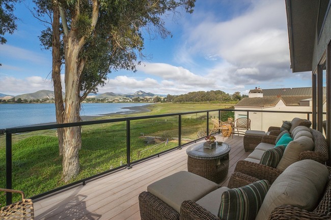
398 Mitchell Dr
San Luis Obispo-Paso Robles, CA
Cuesta-By-The-Sea
074-081-013
CUESTA BY THE SEA BL 35 LT 1 & PTN DORIS ST &TD L
Sfr
San Luis Obispo
X
California
06079C1028H
1
2024
0.21 AC
2025
Coastal SLO
010707
San Luis Obispo/Paso Robles
1,388 SF
DEMOGRAPHICS near 398 Mitchell Dr
1 mile
3 mile
5 mile
2024 Total Population
7,283
17,004
22,866
2029 Population
7,198
16,872
22,753
Pop Growth 2024-2029
(1.17%)
(0.78%)
(0.49%)
Average Age
46
47
48
2024 Total Households
3,073
7,306
10,005
HH Growth 2024-2029
(1.37%)
(0.92%)
(0.60%)
Median Household Inc
$85,272
$82,251
$82,421
Avg Household Size
2.30
2.30
2.20
2024 Avg HH Vehicles
2.00
2.00
2.00
Median Home Value
$691,824
$724,135
$726,797
Median Year Built
1975
1974
1974
Nearby Places
Map Layers
Map Styles
 Street
 Aerial
Transit
 Traffic
 Biking
Places
Listings with unknown addresses are not visible on the map
- Restaurants
- Banks
- Shops
- Fitness
- Groceries
PUBLIC TRANSPORTATION
AIRPORT
San Luis County Regional
Drive
Walk
Distance
San Luis County Regional
30 min
16.3 mi
SALE & LEASE HISTORY
LISTING DATE
SALE/LEASE

Jun 27, 2019
For Sale
Nearby Properties
Address
Land Use
TOTAL SIZE
Lot Size
Zoning
Address
Land Use
TOTAL SIZE
Lot Size
Zoning
21.87 AC
RMF
Address
Land Use
TOTAL SIZE
Lot Size
Zoning
29.99 AC
RMF
Address
Land Use
TOTAL SIZE
Lot Size
Zoning
21,263 SF
0.43 AC
PD
Address
Land Use
TOTAL SIZE
Lot Size
Zoning
70,323 SF
5.38 AC
CR
Address
Land Use
TOTAL SIZE
Lot Size
Zoning
42,742 SF
4.47 AC
VSC
Address
Land Use
TOTAL SIZE
Lot Size
Zoning
48.18 AC
PF
Address
Land Use
TOTAL SIZE
Lot Size
Zoning
1.35 AC
CR
Address
Land Use
TOTAL SIZE
Lot Size
Zoning
0.40 AC
R4
Address
Land Use
TOTAL SIZE
Lot Size
Zoning
18 AC
REC
Address
Land Use
TOTAL SIZE
Lot Size
Zoning
18.33 AC
30
Address
Land Use
TOTAL SIZE
Lot Size
Zoning
2.99 AC
20
Address
Land Use
TOTAL SIZE
Lot Size
Zoning
9.71 AC
RSF
Address
Land Use
TOTAL SIZE
Lot Size
Zoning
18,592 SF
2.15 AC
RMF
Address
Land Use
TOTAL SIZE
Lot Size
Zoning
2.06 AC
RMF
Address
Land Use
TOTAL SIZE
Lot Size
Zoning
38,728 SF
1.46 AC
60
Address
Land Use
TOTAL SIZE
Lot Size
Zoning
4,415 SF
0.29 AC
R1
Address
Land Use
TOTAL SIZE
Lot Size
Zoning
6,037 SF
1.15 AC
RS
Address
Land Use
TOTAL SIZE
Lot Size
Zoning
2,387 SF
0.57 AC
R1
Address
Land Use
TOTAL SIZE
Lot Size
Zoning
17,200 SF
0.40 AC
R2PD
Address
Land Use
TOTAL SIZE
Lot Size
Zoning
16,560 SF
0.86 AC
30
Address
Land Use
TOTAL SIZE
Lot Size
Zoning
Address
Land Use
TOTAL SIZE
Lot Size
Zoning
1.38 AC
RMF
Address
Land Use
TOTAL SIZE
Lot Size
Zoning
1.51 AC
RMF
Address
Land Use
TOTAL SIZE
Lot Size
Zoning
4,495 SF
2.96 AC
RS
Address
Land Use
TOTAL SIZE
Lot Size
Zoning
4,988 SF
0.25 AC
R3
Address
Land Use
TOTAL SIZE
Lot Size
Zoning
4,950 SF
0.27 AC
RSF
Address
Land Use
TOTAL SIZE
Lot Size
Zoning
6,007 SF
0.34 AC
RSF
Address
Land Use
TOTAL SIZE
Lot Size
Zoning
6,382 SF
0.45 AC
CR
Address
Land Use
TOTAL SIZE
Lot Size
Zoning
1.50 AC
OP
Address
Land Use
TOTAL SIZE
Lot Size
Zoning
4,040 SF
5 AC
RS
The World's #1 Commercial Real Estate Marketplace
Connect with us
© 2026 CoStar Group
The information above has been obtained from sources believed reliable. While we do not doubt its accuracy we have not verified it and make no guarantee, warranty or representation about it. It is your responsibility to independently confirm its accuracy and completeness. Any projections, opinions, assumptions, or estimates used are for example only and do not represent the current or future performance of the property. The value of this transaction to you depends on tax and other factors which should be evaluated by your tax, financial, and legal advisors. You and your advisors should conduct a careful, independent investigation of the property to determine to your satisfaction the suitability of the property for your needs.