Property Record
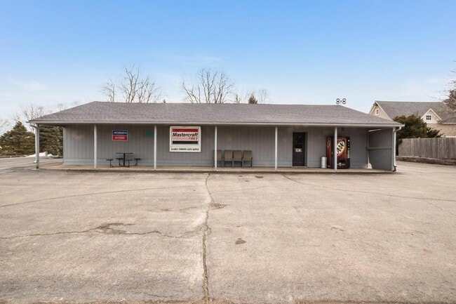
39809 60Th St, Burlington, WI 53105


Property Detail
39809 60Th St
Kenosha, WI
389I PT NE 1/4 SEC 6 T 1 R 19 COMM 434.48 FT E OF NW 1/4 CORN TH S 163 FT TH E 132.18 FT TH N 163 FT TH W 135.34 FT TO POB V1
95-4-119-061-0270
Kenosha
Commercialnec
Wisconsin
B and X Area of moderate flood hazard, usually the area between the limits of the 100-year and 500-year floods.
270
2025
0.38 AC
2025
Kenosha West
002801
Chicago
2,890 SF
NEARBY LISTINGS FOR SALE OR LEASE
-
-
View all Burlington listings for sale on LoopNet.com
DEMOGRAPHICS near 39809 60Th St
1 mile
3 mile
5 mile
2025 Total Population
170
4,700
20,391
2030 Population
167
4,768
20,688
Pop Growth 2025-2030
(1.76%)
+ 1.45%
+ 1.46%
Average Age
45
43
42
2025 Total Households
64
1,844
8,026
HH Growth 2025-2030
(1.56%)
+ 1.46%
+ 1.53%
Median Household Inc
$103,409
$82,966
$88,543
Avg Household Size
2.60
2.50
2.50
2025 Avg HH Vehicles
2.00
2.00
2.00
Median Home Value
$490,908
$304,078
$275,534
Median Year Built
1982
1981
1975
Nearby Places
Map Layers
Map Styles
 Street
 Aerial
Layers
 Traffic
 Biking
Places
Listings with unknown addresses are not visible on the map
- Restaurants
- Banks
- Shops
- Fitness
- Groceries
PUBLIC TRANSPORTATION
AIRPORT
General Mitchell International
Drive
Walk
Distance
General Mitchell International
57 min
43.9 mi
Freight Ports
Port Milwaukee
Drive
Walk
Distance
Port Milwaukee
62 min
47.7 mi
SALE & LEASE HISTORY
LISTING DATE
SALE/LEASE

Mar 05, 2020
For Sale
Nearby Properties
Address
Land Use
TOTAL SIZE
Lot Size
Zoning
Address
Land Use
TOTAL SIZE
Lot Size
Zoning
16,000 SF
11.90 AC
Address
Land Use
TOTAL SIZE
Lot Size
Zoning
Address
Land Use
TOTAL SIZE
Lot Size
Zoning
5,476 SF
18.20 AC
Address
Land Use
TOTAL SIZE
Lot Size
Zoning
74.43 AC
A1
Address
Land Use
TOTAL SIZE
Lot Size
Zoning
0.42 AC
Address
Land Use
TOTAL SIZE
Lot Size
Zoning
118.60 AC
A1
Address
Land Use
TOTAL SIZE
Lot Size
Zoning
3,465 SF
12 AC
Address
Land Use
TOTAL SIZE
Lot Size
Zoning
520 SF
0.61 AC
Address
Land Use
TOTAL SIZE
Lot Size
Zoning
9,600 SF
4.50 AC
Address
Land Use
TOTAL SIZE
Lot Size
Zoning
0.80 AC
R4
Address
Land Use
TOTAL SIZE
Lot Size
Zoning
0.25 AC
Address
Land Use
TOTAL SIZE
Lot Size
Zoning
2.67 AC
A4
Address
Land Use
TOTAL SIZE
Lot Size
Zoning
9,600 SF
8.94 AC
Address
Land Use
TOTAL SIZE
Lot Size
Zoning
0.59 AC
B3
Address
Land Use
TOTAL SIZE
Lot Size
Zoning
4,320 SF
8 AC
Address
Land Use
TOTAL SIZE
Lot Size
Zoning
0.44 AC
Address
Land Use
TOTAL SIZE
Lot Size
Zoning
8,400 SF
3.84 AC
Address
Land Use
TOTAL SIZE
Lot Size
Zoning
Address
Land Use
TOTAL SIZE
Lot Size
Zoning
1.16 AC
R1
Address
Land Use
TOTAL SIZE
Lot Size
Zoning
1.14 AC
Address
Land Use
TOTAL SIZE
Lot Size
Zoning
3.75 AC
R1
Address
Land Use
TOTAL SIZE
Lot Size
Zoning
0.30 AC
Address
Land Use
TOTAL SIZE
Lot Size
Zoning
251 AC
A1
Address
Land Use
TOTAL SIZE
Lot Size
Zoning
101.79 AC
A2
Address
Land Use
TOTAL SIZE
Lot Size
Zoning
9,900 SF
34.62 AC
Address
Land Use
TOTAL SIZE
Lot Size
Zoning
Address
Land Use
TOTAL SIZE
Lot Size
Zoning
83.48 AC
A1
Address
Land Use
TOTAL SIZE
Lot Size
Zoning
70 AC
A1
Address
Land Use
TOTAL SIZE
Lot Size
Zoning
4,021 SF
1.09 AC
Address
Land Use
TOTAL SIZE
Lot Size
Zoning
1,080 SF
30 AC
The World's #1 Commercial Real Estate Marketplace
Connect with us
© 2026 CoStar Group
The information above has been obtained from sources believed reliable. While we do not doubt its accuracy we have not verified it and make no guarantee, warranty or representation about it. It is your responsibility to independently confirm its accuracy and completeness. Any projections, opinions, assumptions, or estimates used are for example only and do not represent the current or future performance of the property. The value of this transaction to you depends on tax and other factors which should be evaluated by your tax, financial, and legal advisors. You and your advisors should conduct a careful, independent investigation of the property to determine to your satisfaction the suitability of the property for your needs.