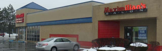
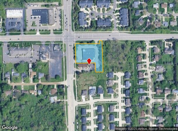
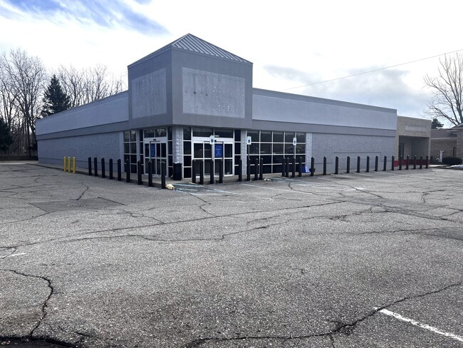
Property Record
3982 John R Rd, Troy, MI 48083
Current Lease Availabilities
NEARBY LISTINGS FOR SALE OR LEASE
Property Detail
3982 John R Rd
Miscellaneous
Oakland
X
Michigan
26125C0553G
1.30 AC
2022
Troy South
2022
Detroit
198000
Detroit-Warren-Dearborn, MI
12,085 SF
20-24-100-032
DEMOGRAPHICS near 3982 John R Rd
1 mile
3 mile
5 mile
2024 Total Population
11,022
93,422
242,744
2029 Population
10,901
92,355
240,088
Pop Growth 2024-2029
(1.10%)
(1.14%)
(1.09%)
Average Age
41
42
41
2024 Total Households
3,694
33,738
97,437
HH Growth 2024-2029
(1.11%)
(1.17%)
(1.11%)
Median Household Inc
$119,727
$88,518
$83,589
Avg Household Size
2.90
2.70
2.40
2024 Avg HH Vehicles
2.00
2.00
2.00
Median Home Value
$341,425
$288,890
$272,208
Median Year Built
1975
1976
1974
Nearby Places
Map Layers
Map Styles
 Street
 Aerial
Transit
 Traffic
 Biking
Places
Listings with unknown addresses are not visible on the map
- Restaurants
- Banks
- Shops
- Fitness
- Groceries
PUBLIC TRANSPORTATION
COMMUTER RAIL
Troy Amtrak Station (Wolverine - Amtrak)
Drive
Walk
Distance
Troy Amtrak Station (Wolverine - Amtrak)
13 min
6.8 mi
Royal Oak Amtrak (Wolverine - Amtrak)
Drive
Walk
Distance
Royal Oak Amtrak (Wolverine - Amtrak)
16 min
8.3 mi
AIRPORT
Windsor International
Drive
Walk
Distance
Windsor International
48 min
28.2 mi
Detroit Metro Wayne County
Drive
Walk
Distance
Detroit Metro Wayne County
53 min
37.8 mi
Freight Ports
Port of Toledo
Drive
Walk
Distance
Port of Toledo
98 min
78.7 mi
Nearby Properties
Address
Land Use
TOTAL SIZE
Lot Size
Zoning
Address
Land Use
TOTAL SIZE
Lot Size
Zoning
272,233 SF
90.90 AC
Address
Land Use
TOTAL SIZE
Lot Size
Zoning
136,137 SF
12.28 AC
RM2
Address
Land Use
TOTAL SIZE
Lot Size
Zoning
300,925 SF
10.13 AC
Address
Land Use
TOTAL SIZE
Lot Size
Zoning
512,471 SF
21 AC
Address
Land Use
TOTAL SIZE
Lot Size
Zoning
512,475 SF
20.02 AC
Address
Land Use
TOTAL SIZE
Lot Size
Zoning
21.76 AC
Address
Land Use
TOTAL SIZE
Lot Size
Zoning
476,388 SF
23 AC
Address
Land Use
TOTAL SIZE
Lot Size
Zoning
40.32 AC
RM-2
Address
Land Use
TOTAL SIZE
Lot Size
Zoning
146.36 AC
MHP
Address
Land Use
TOTAL SIZE
Lot Size
Zoning
157,500 SF
20.79 AC
OM
Address
Land Use
TOTAL SIZE
Lot Size
Zoning
272,233 SF
9.09 AC
OSC
Address
Land Use
TOTAL SIZE
Lot Size
Zoning
399,212 SF
26.18 AC
RM1
Address
Land Use
TOTAL SIZE
Lot Size
Zoning
136,672 SF
32 AC
Address
Land Use
TOTAL SIZE
Lot Size
Zoning
251,735 SF
10.57 AC
RM3
Address
Land Use
TOTAL SIZE
Lot Size
Zoning
250,868 SF
6 AC
OSC
Address
Land Use
TOTAL SIZE
Lot Size
Zoning
2.07 AC
Address
Land Use
TOTAL SIZE
Lot Size
Zoning
362,816 SF
29 AC
Address
Land Use
TOTAL SIZE
Lot Size
Zoning
645 SF
23.16 AC
RM-2
Address
Land Use
TOTAL SIZE
Lot Size
Zoning
300,925 SF
10.13 AC
OSC
Address
Land Use
TOTAL SIZE
Lot Size
Zoning
300,924 SF
10.13 AC
Address
Land Use
TOTAL SIZE
Lot Size
Zoning
94,228 SF
17.66 AC
Address
Land Use
TOTAL SIZE
Lot Size
Zoning
16,022 SF
4.07 AC
OSC
Address
Land Use
TOTAL SIZE
Lot Size
Zoning
150,240 SF
10.70 AC
OSC
Address
Land Use
TOTAL SIZE
Lot Size
Zoning
203,282 SF
17.13 AC
C-2
Address
Land Use
TOTAL SIZE
Lot Size
Zoning
336,720 SF
63.11 AC
CR1
Address
Land Use
TOTAL SIZE
Lot Size
Zoning
245,371 SF
15.93 AC
RC
Address
Land Use
TOTAL SIZE
Lot Size
Zoning
276,235 SF
14.49 AC
OM
Address
Land Use
TOTAL SIZE
Lot Size
Zoning
76,260 SF
8.09 AC
Address
Land Use
TOTAL SIZE
Lot Size
Zoning
8,914 SF
5 AC
Address
Land Use
TOTAL SIZE
Lot Size
Zoning
236,900 SF
20.34 AC
RM1
The World's #1 Commercial Real Estate Marketplace
Connect with us
© 2026 CoStar Group
The information above has been obtained from sources believed reliable. While we do not doubt its accuracy we have not verified it and make no guarantee, warranty or representation about it. It is your responsibility to independently confirm its accuracy and completeness. Any projections, opinions, assumptions, or estimates used are for example only and do not represent the current or future performance of the property. The value of this transaction to you depends on tax and other factors which should be evaluated by your tax, financial, and legal advisors. You and your advisors should conduct a careful, independent investigation of the property to determine to your satisfaction the suitability of the property for your needs.