Property Record
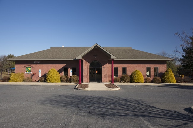
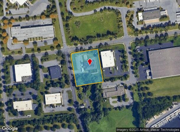
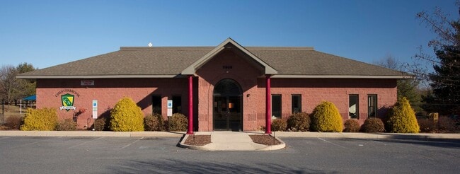
3986 Township Line Rd, Bethlehem, PA 18020

NEARBY LISTINGS FOR SALE OR LEASE
Property Detail
3986 Township Line Rd
M6-3-1B-0205
Lehigh Valley Industrial Park V
Animalhospitalvet
Northampton
X
Pennsylvania
42095C0261E
2.22 AC
2025
Lehigh Valley
2025
Philadelphia
017605
Allentown-Bethlehem-Easton, PA-NJ
9,256 SF
DEMOGRAPHICS near 3986 Township Line Rd
1 Mile
3 Mile
5 Mile
2024 Total Population
1,756
45,833
142,275
2029 Population
1,759
46,014
143,141
Pop Growth 2024-2029
+ 0.17%
+ 0.39%
+ 0.61%
Average Age
49
45
42
2024 Total Households
785
17,764
55,001
HH Growth 2024-2029
+ 0.38%
+ 0.36%
+ 0.60%
Median Household Inc
$89,739
$95,118
$74,593
Avg Household Size
2.20
2.50
2.40
2024 Avg HH Vehicles
2.00
2.00
2.00
Median Home Value
$338,924
$291,914
$258,105
Median Year Built
1994
1978
1968
Nearby Places
Map Layers
Map Styles
 Street
 Aerial
- Restaurants
- Banks
- Shops
- Fitness
- Groceries
PUBLIC TRANSPORTATION
AIRPORT
Lehigh Valley International
DRIVE
WALK
Distance
Lehigh Valley International
12 min
5.7 mi
Freight Ports
Port of Philadelphia
DRIVE
WALK
Distance
Port of Philadelphia
93 min
70.5 mi
SALE & LEASE HISTORY
LISTING DATE
SALE/LEASE

Mar 20, 2019
For Sale
Mar 19, 2021
For Lease
Mar 18, 2019
For Sale
Nearby Properties
Address
Land Use
TOTAL SIZE
Lot Size
Zoning
Address
Land Use
TOTAL SIZE
Lot Size
Zoning
605,906 SF
94.28 AC
A
Address
Land Use
TOTAL SIZE
Lot Size
Zoning
104,379 SF
21.57 AC
CS
Address
Land Use
TOTAL SIZE
Lot Size
Zoning
164,451 SF
15.06 AC
PI
Address
Land Use
TOTAL SIZE
Lot Size
Zoning
302,378 SF
83.53 AC
A
Address
Land Use
TOTAL SIZE
Lot Size
Zoning
276,484 SF
31.19 AC
A
Address
Land Use
TOTAL SIZE
Lot Size
Zoning
52,164 SF
124.81 AC
IN
Address
Land Use
TOTAL SIZE
Lot Size
Zoning
57,635 SF
2.69 AC
I
Address
Land Use
TOTAL SIZE
Lot Size
Zoning
298,660 SF
37.43 AC
PIBD
Address
Land Use
TOTAL SIZE
Lot Size
Zoning
533,165 SF
54.66 AC
LI/BP
Address
Land Use
TOTAL SIZE
Lot Size
Zoning
92,428 SF
3.88 AC
CS
Address
Land Use
TOTAL SIZE
Lot Size
Zoning
524,948 SF
35.66 AC
LI
Address
Land Use
TOTAL SIZE
Lot Size
Zoning
249,872 SF
41.83 AC
PC
Address
Land Use
TOTAL SIZE
Lot Size
Zoning
319,788 SF
60 AC
IN
Address
Land Use
TOTAL SIZE
Lot Size
Zoning
512,902 SF
35.18 AC
LI
Address
Land Use
TOTAL SIZE
Lot Size
Zoning
73,432 SF
3 AC
CS
Address
Land Use
TOTAL SIZE
Lot Size
Zoning
601,903 SF
41.68 AC
LI
Address
Land Use
TOTAL SIZE
Lot Size
Zoning
63,711 SF
31.56 AC
RR
Address
Land Use
TOTAL SIZE
Lot Size
Zoning
42,465 SF
7.28 AC
LI
Address
Land Use
TOTAL SIZE
Lot Size
Zoning
50,036 SF
1.03 AC
I
Address
Land Use
TOTAL SIZE
Lot Size
Zoning
539,133 SF
47 AC
LI
Address
Land Use
TOTAL SIZE
Lot Size
Zoning
1,456 SF
29.36 AC
A
Address
Land Use
TOTAL SIZE
Lot Size
Zoning
437,612 SF
42.26 AC
LI/BP
Address
Land Use
TOTAL SIZE
Lot Size
Zoning
36,005 SF
3.84 AC
I
Address
Land Use
TOTAL SIZE
Lot Size
Zoning
508,835 SF
34.92 AC
A
Address
Land Use
TOTAL SIZE
Lot Size
Zoning
67,133 SF
2.58 AC
CS
Address
Land Use
TOTAL SIZE
Lot Size
Zoning
208,053 SF
45.58 AC
I
Address
Land Use
TOTAL SIZE
Lot Size
Zoning
244,478 SF
26.32 AC
LI
Address
Land Use
TOTAL SIZE
Lot Size
Zoning
307,425 SF
37.13 AC
A
Address
Land Use
TOTAL SIZE
Lot Size
Zoning
109,753 SF
15.33 AC
PIBD
Address
Land Use
TOTAL SIZE
Lot Size
Zoning
294,412 SF
28.72 AC
A
The World's #1 Commercial Real Estate Marketplace
Connect with us
© 2025 CoStar Group
The information above has been obtained from sources believed reliable. While we do not doubt its accuracy we have not verified it and make no guarantee, warranty or representation about it. It is your responsibility to independently confirm its accuracy and completeness. Any projections, opinions, assumptions, or estimates used are for example only and do not represent the current or future performance of the property. The value of this transaction to you depends on tax and other factors which should be evaluated by your tax, financial, and legal advisors. You and your advisors should conduct a careful, independent investigation of the property to determine to your satisfaction the suitability of the property for your needs.