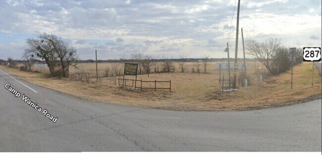
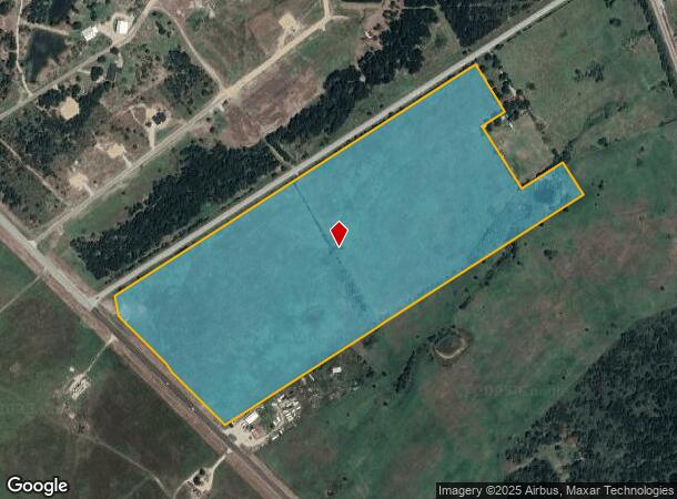
Property Record
3989 S Us Highway 287, Corsicana, TX 75109
NEARBY LISTINGS FOR SALE OR LEASE
Property Detail
3989 S Us Highway 287
Corsicana, TX
J Smith Abst
42936
ABS A10726 J SMITH ABST TRACT 16 57.17 ACRES
Agriculturalnec
Navarro
A
Texas
48349C0400D
57.17 AC
2025
Texas East Area
2025
Other Market Areas
970701
DEMOGRAPHICS near 3989 S Us Highway 287
1 Mile
3 Mile
5 Mile
2024 Total Population
177
923
9,768
2029 Population
199
1,034
10,939
Pop Growth 2024-2029
+ 12.43%
+ 12.03%
+ 11.99%
Average Age
42
44
38
2024 Total Households
64
347
3,281
HH Growth 2024-2029
+ 10.94%
+ 11.82%
+ 11.83%
Median Household Inc
$57,499
$59,047
$42,954
Avg Household Size
2.80
2.70
2.90
2024 Avg HH Vehicles
2.00
2.00
2.00
Median Home Value
$180,768
$182,352
$98,585
Median Year Built
1998
1998
1983
Nearby Places
Map Layers
Map Styles
 Street
 Aerial
- Restaurants
- Banks
- Shops
- Fitness
- Groceries
SALE & LEASE HISTORY
LISTING DATE
SALE/LEASE

May 25, 2022
For Sale
Nearby Properties
Address
Land Use
TOTAL SIZE
Lot Size
Zoning
Address
Land Use
TOTAL SIZE
Lot Size
Zoning
14.46 AC
Address
Land Use
TOTAL SIZE
Lot Size
Zoning
54,574 SF
89.08 AC
Address
Land Use
TOTAL SIZE
Lot Size
Zoning
10.59 AC
Address
Land Use
TOTAL SIZE
Lot Size
Zoning
89,820 SF
22 AC
Address
Land Use
TOTAL SIZE
Lot Size
Zoning
46,285 SF
8.67 AC
Address
Land Use
TOTAL SIZE
Lot Size
Zoning
103,320 SF
11.88 AC
Address
Land Use
TOTAL SIZE
Lot Size
Zoning
56,852 SF
2.03 AC
Address
Land Use
TOTAL SIZE
Lot Size
Zoning
10,540 SF
10.96 AC
Address
Land Use
TOTAL SIZE
Lot Size
Zoning
132,681 SF
186.53 AC
Address
Land Use
TOTAL SIZE
Lot Size
Zoning
51,724 SF
2 AC
Address
Land Use
TOTAL SIZE
Lot Size
Zoning
10,584 SF
1.30 AC
Address
Land Use
TOTAL SIZE
Lot Size
Zoning
20,013 SF
2.22 AC
Address
Land Use
TOTAL SIZE
Lot Size
Zoning
21,950 SF
10.01 AC
Address
Land Use
TOTAL SIZE
Lot Size
Zoning
10,215 SF
2 AC
Address
Land Use
TOTAL SIZE
Lot Size
Zoning
52.43 AC
Address
Land Use
TOTAL SIZE
Lot Size
Zoning
2,000 SF
5.73 AC
Address
Land Use
TOTAL SIZE
Lot Size
Zoning
20,816 SF
1.95 AC
Address
Land Use
TOTAL SIZE
Lot Size
Zoning
2,000 SF
220.97 AC
Address
Land Use
TOTAL SIZE
Lot Size
Zoning
25,600 SF
3.78 AC
Address
Land Use
TOTAL SIZE
Lot Size
Zoning
3,742 SF
1.32 AC
Address
Land Use
TOTAL SIZE
Lot Size
Zoning
89,600 SF
10.78 AC
Address
Land Use
TOTAL SIZE
Lot Size
Zoning
3,407 SF
1.38 AC
Address
Land Use
TOTAL SIZE
Lot Size
Zoning
3,576 SF
3.08 AC
Address
Land Use
TOTAL SIZE
Lot Size
Zoning
Address
Land Use
TOTAL SIZE
Lot Size
Zoning
2,662 SF
1.27 AC
Address
Land Use
TOTAL SIZE
Lot Size
Zoning
15.01 AC
Address
Land Use
TOTAL SIZE
Lot Size
Zoning
2,691 SF
0.80 AC
Address
Land Use
TOTAL SIZE
Lot Size
Zoning
46.06 AC
Address
Land Use
TOTAL SIZE
Lot Size
Zoning
2,729 SF
0.77 AC
The World's #1 Commercial Real Estate Marketplace
Connect with us
© 2025 CoStar Group
The information above has been obtained from sources believed reliable. While we do not doubt its accuracy we have not verified it and make no guarantee, warranty or representation about it. It is your responsibility to independently confirm its accuracy and completeness. Any projections, opinions, assumptions, or estimates used are for example only and do not represent the current or future performance of the property. The value of this transaction to you depends on tax and other factors which should be evaluated by your tax, financial, and legal advisors. You and your advisors should conduct a careful, independent investigation of the property to determine to your satisfaction the suitability of the property for your needs.