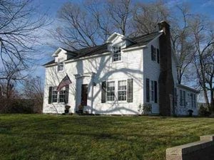
Property Record
399 Elsmere Ave, Delmar, NY 12054
NEARBY LISTINGS FOR SALE OR LEASE
Property Detail
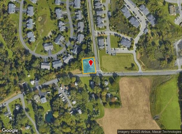
399 Elsmere Ave
Albany-Schenectady-Troy, NY
Albany
012200-097-009-0002-005-002-0000
New York
Sfr
0.40 AC
X
W Outer Albany County
36001C0302D
Albany/Schenectady/Troy
2,280 SF
DEMOGRAPHICS near 399 Elsmere Ave
1 Mile
3 Mile
5 Mile
2024 Total Population
6,001
28,430
108,399
2029 Population
5,964
28,239
107,254
Pop Growth 2024-2029
(0.62%)
(0.67%)
(1.06%)
Average Age
43
43
40
2024 Total Households
2,350
11,560
47,776
HH Growth 2024-2029
(0.64%)
(0.68%)
(1.07%)
Median Household Inc
$150,887
$110,982
$73,574
Avg Household Size
2.50
2.40
2.10
2024 Avg HH Vehicles
2.00
2.00
1.00
Median Home Value
$334,811
$318,055
$257,403
Median Year Built
1980
1972
1956
Nearby Places
Map Layers
Map Styles
 Street
 Aerial
- Restaurants
- Banks
- Shops
- Fitness
- Groceries
PUBLIC TRANSPORTATION
AIRPORT
Albany International
DRIVE
WALK
Distance
Albany International
29 min
16.6 mi
SALE & LEASE HISTORY
LISTING DATE
SALE/LEASE

Mar 05, 2021
For Sale
Jul 10, 2020
For Sale
Nearby Properties
Address
Land Use
TOTAL SIZE
Lot Size
Zoning
Address
Land Use
TOTAL SIZE
Lot Size
Zoning
83.50 AC
Address
Land Use
TOTAL SIZE
Lot Size
Zoning
191.95 AC
LC
Address
Land Use
TOTAL SIZE
Lot Size
Zoning
5,248 SF
200.90 AC
LC
Address
Land Use
TOTAL SIZE
Lot Size
Zoning
315,680 SF
73.80 AC
RA
Address
Land Use
TOTAL SIZE
Lot Size
Zoning
46,408 SF
594.50 AC
I
Address
Land Use
TOTAL SIZE
Lot Size
Zoning
18,390 SF
15.52 AC
PDD
Address
Land Use
TOTAL SIZE
Lot Size
Zoning
203,781 SF
39.30 AC
C
Address
Land Use
TOTAL SIZE
Lot Size
Zoning
0.01 AC
I
Address
Land Use
TOTAL SIZE
Lot Size
Zoning
28,160 SF
198.40 AC
I
Address
Land Use
TOTAL SIZE
Lot Size
Zoning
7,472 SF
18.40 AC
PDD
Address
Land Use
TOTAL SIZE
Lot Size
Zoning
204,860 SF
26.40 AC
CR
Address
Land Use
TOTAL SIZE
Lot Size
Zoning
45,898 SF
12.91 AC
CH
Address
Land Use
TOTAL SIZE
Lot Size
Zoning
5,587 SF
48.83 AC
PDD
Address
Land Use
TOTAL SIZE
Lot Size
Zoning
140,609 SF
14.50 AC
CR
Address
Land Use
TOTAL SIZE
Lot Size
Zoning
44,097 SF
9 AC
CH
Address
Land Use
TOTAL SIZE
Lot Size
Zoning
115,080 SF
18.20 AC
ME
Address
Land Use
TOTAL SIZE
Lot Size
Zoning
121,323 SF
13.54 AC
CH
Address
Land Use
TOTAL SIZE
Lot Size
Zoning
17,489 SF
6.41 AC
C2
Address
Land Use
TOTAL SIZE
Lot Size
Zoning
9,120 SF
12.95 AC
H
Address
Land Use
TOTAL SIZE
Lot Size
Zoning
80,096 SF
14.67 AC
H
Address
Land Use
TOTAL SIZE
Lot Size
Zoning
274,352 SF
22.59 AC
I
Address
Land Use
TOTAL SIZE
Lot Size
Zoning
165,396 SF
74.47 AC
R1A
Address
Land Use
TOTAL SIZE
Lot Size
Zoning
134,567 SF
32.80 AC
C
Address
Land Use
TOTAL SIZE
Lot Size
Zoning
16.80 AC
Address
Land Use
TOTAL SIZE
Lot Size
Zoning
49,036 SF
1.84 AC
CH
Address
Land Use
TOTAL SIZE
Lot Size
Zoning
30,459 SF
14 AC
C
Address
Land Use
TOTAL SIZE
Lot Size
Zoning
71,721 SF
16.65 AC
C
Address
Land Use
TOTAL SIZE
Lot Size
Zoning
17,212 SF
88.10 AC
I
Address
Land Use
TOTAL SIZE
Lot Size
Zoning
69,574 SF
21.69 AC
RA
Address
Land Use
TOTAL SIZE
Lot Size
Zoning
87,773 SF
29.40 AC
RH
The World's #1 Commercial Real Estate Marketplace
Connect with us
© 2025 CoStar Group
The information above has been obtained from sources believed reliable. While we do not doubt its accuracy we have not verified it and make no guarantee, warranty or representation about it. It is your responsibility to independently confirm its accuracy and completeness. Any projections, opinions, assumptions, or estimates used are for example only and do not represent the current or future performance of the property. The value of this transaction to you depends on tax and other factors which should be evaluated by your tax, financial, and legal advisors. You and your advisors should conduct a careful, independent investigation of the property to determine to your satisfaction the suitability of the property for your needs.