Property Record
399 Main Ave, Norwalk, CT 06851

NEARBY LISTINGS FOR SALE OR LEASE
-
-
View all Norwalk listings for sale on LoopNet.com
Property Detail
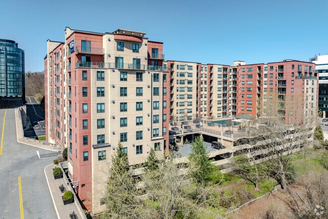
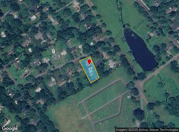
399 Main Ave
NORW-000005-000037-000002-000002
Merritt On The Riv
Apartmenthouse100plusunits
Fairfield
AE
Connecticut
09001C0393G
2-2
2025
2.36 AC
2025
Merritt
042700
Westchester/So Connecticut
271,344 SF
Bridgeport-Stamford-Norwalk, CT
DEMOGRAPHICS near 399 Main Ave
1 Mile
3 Mile
5 Mile
2024 Total Population
8,344
70,024
145,648
2029 Population
8,381
70,008
145,848
Pop Growth 2024-2029
+ 0.44%
(0.02%)
+ 0.14%
Average Age
41
41
40
2024 Total Households
3,673
27,331
54,486
HH Growth 2024-2029
+ 0.46%
(0.03%)
+ 0.11%
Median Household Inc
$115,528
$107,037
$120,546
Avg Household Size
2.20
2.50
2.60
2024 Avg HH Vehicles
2.00
2.00
2.00
Median Home Value
$446,781
$521,539
$713,539
Median Year Built
1979
1968
1966
Nearby Places
Map Layers
Map Styles
 Street
 Aerial
- Restaurants
- Banks
- Shops
- Fitness
- Groceries
PUBLIC TRANSPORTATION
COMMUTER RAIL
Bethel Station (New Haven Line - Metro-North Commuter Railroad Company (Metro-North))
DRIVE
WALK
Distance
Bethel Station (New Haven Line - Metro-North Commuter Railroad Company (Metro-North))
16 min
8.1 mi
Danbury Station (New Haven Line - Metro-North Commuter Railroad Company (Metro-North))
DRIVE
WALK
Distance
Danbury Station (New Haven Line - Metro-North Commuter Railroad Company (Metro-North))
17 min
9.1 mi
AIRPORT
Tweed/New Haven
DRIVE
WALK
Distance
Tweed/New Haven
48 min
29.9 mi
Freight Ports
Port of New Haven
DRIVE
WALK
Distance
Port of New Haven
43 min
27.1 mi
Nearby Properties
Address
Land Use
TOTAL SIZE
Lot Size
Zoning
Address
Land Use
TOTAL SIZE
Lot Size
Zoning
114.88 AC
CA
Address
Land Use
TOTAL SIZE
Lot Size
Zoning
37.66 AC
R-2
Address
Land Use
TOTAL SIZE
Lot Size
Zoning
20.49 AC
R-2
Address
Land Use
TOTAL SIZE
Lot Size
Zoning
86,039 SF
15.68 AC
R-2
Address
Land Use
TOTAL SIZE
Lot Size
Zoning
21.20 AC
PS
Address
Land Use
TOTAL SIZE
Lot Size
Zoning
167,124 SF
37.33 AC
M-1
Address
Land Use
TOTAL SIZE
Lot Size
Zoning
133,516 SF
34.02 AC
R-1
Address
Land Use
TOTAL SIZE
Lot Size
Zoning
8.13 AC
B-1/2
Address
Land Use
TOTAL SIZE
Lot Size
Zoning
11,000 SF
185 AC
FHAR
Address
Land Use
TOTAL SIZE
Lot Size
Zoning
43.38 AC
EH-10
Address
Land Use
TOTAL SIZE
Lot Size
Zoning
1,498 SF
11.75 AC
R-2
Address
Land Use
TOTAL SIZE
Lot Size
Zoning
13,922 SF
62.75 AC
EH-10
Address
Land Use
TOTAL SIZE
Lot Size
Zoning
15 AC
R-2
Address
Land Use
TOTAL SIZE
Lot Size
Zoning
3.97 AC
P-1
Address
Land Use
TOTAL SIZE
Lot Size
Zoning
9.60 AC
R-1
Address
Land Use
TOTAL SIZE
Lot Size
Zoning
62,765 SF
29.91 AC
R-3
Address
Land Use
TOTAL SIZE
Lot Size
Zoning
23.88 AC
M-1
Address
Land Use
TOTAL SIZE
Lot Size
Zoning
102.71 AC
M-2A
Address
Land Use
TOTAL SIZE
Lot Size
Zoning
23.95 AC
M-1
Address
Land Use
TOTAL SIZE
Lot Size
Zoning
154.75 AC
CA
Address
Land Use
TOTAL SIZE
Lot Size
Zoning
212,698 SF
24.68 AC
M-1
Address
Land Use
TOTAL SIZE
Lot Size
Zoning
252,800 SF
22.70 AC
M-1
Address
Land Use
TOTAL SIZE
Lot Size
Zoning
12,074 SF
22.73 AC
SDD1
Address
Land Use
TOTAL SIZE
Lot Size
Zoning
45,079 SF
Address
Land Use
TOTAL SIZE
Lot Size
Zoning
30,220 SF
5.48 AC
M-4
Address
Land Use
TOTAL SIZE
Lot Size
Zoning
13.30 AC
M-5
Address
Land Use
TOTAL SIZE
Lot Size
Zoning
158,754 SF
17.74 AC
M-1
Address
Land Use
TOTAL SIZE
Lot Size
Zoning
13.98 AC
M-4
Address
Land Use
TOTAL SIZE
Lot Size
Zoning
46,620 SF
7.55 AC
B-1/2
Address
Land Use
TOTAL SIZE
Lot Size
Zoning
64,426 SF
13.22 AC
R-2
The World's #1 Commercial Real Estate Marketplace
Connect with us
© 2026 CoStar Group
The information above has been obtained from sources believed reliable. While we do not doubt its accuracy we have not verified it and make no guarantee, warranty or representation about it. It is your responsibility to independently confirm its accuracy and completeness. Any projections, opinions, assumptions, or estimates used are for example only and do not represent the current or future performance of the property. The value of this transaction to you depends on tax and other factors which should be evaluated by your tax, financial, and legal advisors. You and your advisors should conduct a careful, independent investigation of the property to determine to your satisfaction the suitability of the property for your needs.