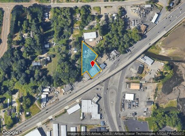
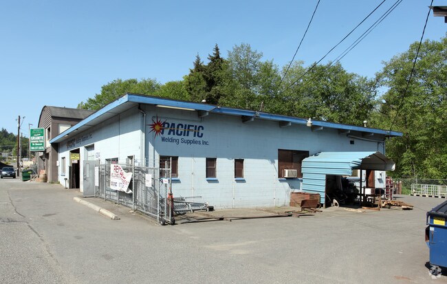
Property Record
3995 State Highway 3 W, Bremerton, WA 98312

NEARBY LISTINGS FOR SALE OR LEASE
-
-
View all Bremerton listings for sale on LoopNet.com
Property Detail
3995 State Highway 3 W
Bremerton-Silverdale, WA
Sp 3003R
322401-1-067-2007
PARCEL I: LOT A OF SHORT PLAT 3003R RECORDED FEBRUARY 1, 1983 UNDER RECORDING NO. 8302010109, BEING A RE-RECORD OF RECORDING NO. 8211010098, RECORDS OF KITSAP COUNTY, BEING A PORTION OF THE SOUTHWEST QUARTER OF THE NORTHEAST QUARTER, SECTION 32, TOWN
Commercialnec
Kitsap
AE
Washington
53035C0364F
a
2025
0.73 AC
2026
West Bremerton
092102
Bremerton/Silverdale
5,021 SF
DEMOGRAPHICS near 3995 State Highway 3 W
1 Mile
3 Mile
5 Mile
2024 Total Population
1,291
25,124
78,907
2029 Population
1,300
25,889
80,189
Pop Growth 2024-2029
+ 0.70%
+ 3.04%
+ 1.62%
Average Age
35
39
39
2024 Total Households
440
9,729
29,450
HH Growth 2024-2029
+ 0.68%
+ 3.26%
+ 1.82%
Median Household Inc
$94,999
$72,700
$70,372
Avg Household Size
2.90
2.50
2.40
2024 Avg HH Vehicles
2.00
2.00
2.00
Median Home Value
$443,085
$410,792
$399,580
Median Year Built
2003
1994
1979
Nearby Places
Map Layers
Map Styles
 Street
 Aerial
- Restaurants
- Banks
- Shops
- Fitness
- Groceries
PUBLIC TRANSPORTATION
AIRPORT
Seattle-Tacoma International
DRIVE
WALK
Distance
Seattle-Tacoma International
68 min
49.5 mi
Freight Ports
Port of Seattle
DRIVE
WALK
Distance
Port of Seattle
78 min
59.8 mi
Nearby Properties
Address
Land Use
TOTAL SIZE
Lot Size
Zoning
Address
Land Use
TOTAL SIZE
Lot Size
Zoning
552 SF
17.39 AC
CITY
Address
Land Use
TOTAL SIZE
Lot Size
Zoning
21,408 SF
8.26 AC
BVSAP
Address
Land Use
TOTAL SIZE
Lot Size
Zoning
143,022 SF
11.24 AC
R4
Address
Land Use
TOTAL SIZE
Lot Size
Zoning
127,853 SF
7.41 AC
R4
Address
Land Use
TOTAL SIZE
Lot Size
Zoning
135,371 SF
6.04 AC
R4
Address
Land Use
TOTAL SIZE
Lot Size
Zoning
112,847 SF
6.80 AC
UM
Address
Land Use
TOTAL SIZE
Lot Size
Zoning
110,994 SF
5.35 AC
R4
Address
Land Use
TOTAL SIZE
Lot Size
Zoning
118,263 SF
27.49 AC
PSIC-B
Address
Land Use
TOTAL SIZE
Lot Size
Zoning
68,079 SF
2.16 AC
BVSAP
Address
Land Use
TOTAL SIZE
Lot Size
Zoning
73,931 SF
11.72 AC
FC
Address
Land Use
TOTAL SIZE
Lot Size
Zoning
43,944 SF
2.64 AC
FC
Address
Land Use
TOTAL SIZE
Lot Size
Zoning
55,866 SF
8.48 AC
FC
Address
Land Use
TOTAL SIZE
Lot Size
Zoning
68,708 SF
7.89 AC
PF
Address
Land Use
TOTAL SIZE
Lot Size
Zoning
520 SF
7.79 AC
C
Address
Land Use
TOTAL SIZE
Lot Size
Zoning
42,665 SF
5.55 AC
FC
Address
Land Use
TOTAL SIZE
Lot Size
Zoning
51,933 SF
4.07 AC
C
Address
Land Use
TOTAL SIZE
Lot Size
Zoning
43,318 SF
2.54 AC
R4
Address
Land Use
TOTAL SIZE
Lot Size
Zoning
75,000 SF
3.61 AC
LI
Address
Land Use
TOTAL SIZE
Lot Size
Zoning
52,601 SF
6.30 AC
BVSAP
Address
Land Use
TOTAL SIZE
Lot Size
Zoning
49,222 SF
3.39 AC
BPMU
Address
Land Use
TOTAL SIZE
Lot Size
Zoning
29,079 SF
9.95 AC
PF
Address
Land Use
TOTAL SIZE
Lot Size
Zoning
46,395 SF
2.41 AC
FC
Address
Land Use
TOTAL SIZE
Lot Size
Zoning
40,131 SF
4.90 AC
FC
Address
Land Use
TOTAL SIZE
Lot Size
Zoning
36,094 SF
2.84 AC
FC
Address
Land Use
TOTAL SIZE
Lot Size
Zoning
30,367 SF
4.55 AC
FC
Address
Land Use
TOTAL SIZE
Lot Size
Zoning
40,144 SF
5 AC
CITY
Address
Land Use
TOTAL SIZE
Lot Size
Zoning
31,961 SF
2.91 AC
R4
Address
Land Use
TOTAL SIZE
Lot Size
Zoning
38,580 SF
2.44 AC
I
Address
Land Use
TOTAL SIZE
Lot Size
Zoning
4,280 SF
0.95 AC
CC
Address
Land Use
TOTAL SIZE
Lot Size
Zoning
42,400 SF
5.40 AC
FC
The World's #1 Commercial Real Estate Marketplace
Connect with us
© 2025 CoStar Group
The information above has been obtained from sources believed reliable. While we do not doubt its accuracy we have not verified it and make no guarantee, warranty or representation about it. It is your responsibility to independently confirm its accuracy and completeness. Any projections, opinions, assumptions, or estimates used are for example only and do not represent the current or future performance of the property. The value of this transaction to you depends on tax and other factors which should be evaluated by your tax, financial, and legal advisors. You and your advisors should conduct a careful, independent investigation of the property to determine to your satisfaction the suitability of the property for your needs.