Property Record
3Rd St, Leetsdale, PA 15056
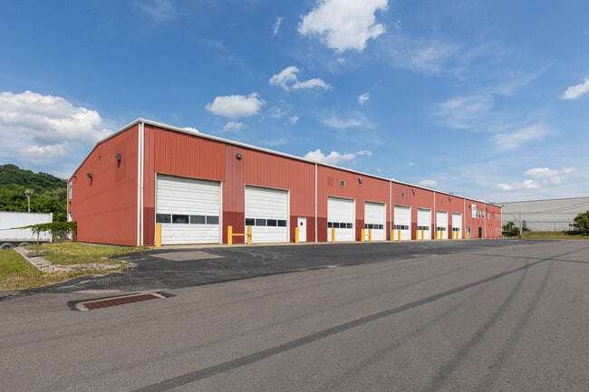

Property Detail
3Rd St
Pittsburgh, PA
U S B&L ASSN PL 55-56 LOT 100X120 SECOND ST
0704-K-00096-0000-00
ALLEGHENY
Truckterminal
Pennsylvania
AE The base floodplain where base flood elevations are provided. AE Zones are now used on new format FIRMs instead of A1-A30 Zones.
106
2024
0.67 AC
2025
North Pittsburgh
448000
Pittsburgh
NEARBY LISTINGS FOR SALE OR LEASE
DEMOGRAPHICS near 3Rd St
1 mile
3 mile
5 mile
2025 Total Population
2,760
35,509
77,986
2030 Population
2,721
35,258
77,329
Pop Growth 2025-2030
(1.41%)
(0.71%)
(0.84%)
Average Age
43
41
42
2025 Total Households
1,158
14,454
33,136
HH Growth 2025-2030
(1.21%)
(0.82%)
(0.96%)
Median Household Inc
$82,608
$85,925
$77,004
Avg Household Size
2.40
2.30
2.20
2025 Avg HH Vehicles
2.00
2.00
2.00
Median Home Value
$225,000
$259,609
$223,639
Median Year Built
1948
1955
1957
Nearby Places
Map Layers
Map Styles
 Street
 Aerial
Transit
 Traffic
 Biking
Places
Listings with unknown addresses are not visible on the map
- Restaurants
- Banks
- Shops
- Fitness
- Groceries
PUBLIC TRANSPORTATION
AIRPORT
Pittsburgh International
Drive
Walk
Distance
Pittsburgh International
20 min
9.0 mi
Freight Ports
Port of Toledo
Drive
Walk
Distance
Port of Toledo
249 min
216.4 mi
SALE & LEASE HISTORY
LISTING DATE
SALE/LEASE

Sep 13, 2023
For Lease
Nearby Properties
Address
Land Use
TOTAL SIZE
Lot Size
Zoning
Address
Land Use
TOTAL SIZE
Lot Size
Zoning
3,320 SF
180.98 AC
Address
Land Use
TOTAL SIZE
Lot Size
Zoning
6.24 AC
Address
Land Use
TOTAL SIZE
Lot Size
Zoning
2,364 SF
17.51 AC
Address
Land Use
TOTAL SIZE
Lot Size
Zoning
32,196 SF
13.61 AC
Address
Land Use
TOTAL SIZE
Lot Size
Zoning
15,134 SF
19.73 AC
Address
Land Use
TOTAL SIZE
Lot Size
Zoning
2.86 AC
Address
Land Use
TOTAL SIZE
Lot Size
Zoning
39.36 AC
Address
Land Use
TOTAL SIZE
Lot Size
Zoning
5.98 AC
Address
Land Use
TOTAL SIZE
Lot Size
Zoning
1,714 SF
64.43 AC
Address
Land Use
TOTAL SIZE
Lot Size
Zoning
22.20 AC
Address
Land Use
TOTAL SIZE
Lot Size
Zoning
11.19 AC
Address
Land Use
TOTAL SIZE
Lot Size
Zoning
8.33 AC
Address
Land Use
TOTAL SIZE
Lot Size
Zoning
15.02 AC
Address
Land Use
TOTAL SIZE
Lot Size
Zoning
8,578 SF
50.54 AC
Address
Land Use
TOTAL SIZE
Lot Size
Zoning
33.06 AC
Address
Land Use
TOTAL SIZE
Lot Size
Zoning
16.31 AC
Address
Land Use
TOTAL SIZE
Lot Size
Zoning
74,461 SF
4.77 AC
Address
Land Use
TOTAL SIZE
Lot Size
Zoning
18.14 AC
Address
Land Use
TOTAL SIZE
Lot Size
Zoning
Address
Land Use
TOTAL SIZE
Lot Size
Zoning
5.61 AC
Address
Land Use
TOTAL SIZE
Lot Size
Zoning
17.84 AC
Address
Land Use
TOTAL SIZE
Lot Size
Zoning
48.77 AC
Address
Land Use
TOTAL SIZE
Lot Size
Zoning
28.20 AC
Address
Land Use
TOTAL SIZE
Lot Size
Zoning
Address
Land Use
TOTAL SIZE
Lot Size
Zoning
12.21 AC
Address
Land Use
TOTAL SIZE
Lot Size
Zoning
26.20 AC
Address
Land Use
TOTAL SIZE
Lot Size
Zoning
28.42 AC
Address
Land Use
TOTAL SIZE
Lot Size
Zoning
7.68 AC
Address
Land Use
TOTAL SIZE
Lot Size
Zoning
2.29 AC
Address
Land Use
TOTAL SIZE
Lot Size
Zoning
4,746 SF
3.73 AC
The World's #1 Commercial Real Estate Marketplace
Connect with us
© 2026 CoStar Group
The information above has been obtained from sources believed reliable. While we do not doubt its accuracy we have not verified it and make no guarantee, warranty or representation about it. It is your responsibility to independently confirm its accuracy and completeness. Any projections, opinions, assumptions, or estimates used are for example only and do not represent the current or future performance of the property. The value of this transaction to you depends on tax and other factors which should be evaluated by your tax, financial, and legal advisors. You and your advisors should conduct a careful, independent investigation of the property to determine to your satisfaction the suitability of the property for your needs.