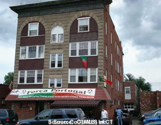
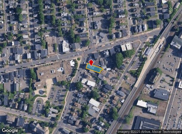
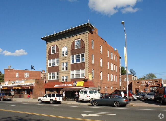
Property Record
48 New Park Ave, Hartford, CT 06106
NEARBY LISTINGS FOR SALE OR LEASE
Property Detail
48 New Park Ave
HTFD-000136-000480-000236
Hartford
Commercialofficeresidentialmixeduse
Connecticut
X
236
09003C0364F
0.17 AC
2024
Parkville
2025
Hartford
502800
Hartford-West Hartford-East Hartford, CT
DEMOGRAPHICS near 48 New Park Ave
1 Mile
3 Mile
5 Mile
2024 Total Population
33,094
164,396
263,322
2029 Population
32,892
163,526
261,982
Pop Growth 2024-2029
(0.61%)
(0.53%)
(0.51%)
Average Age
38
38
39
2024 Total Households
14,545
66,762
105,718
HH Growth 2024-2029
(0.54%)
(0.37%)
(0.43%)
Median Household Inc
$41,099
$53,347
$62,637
Avg Household Size
2.10
2.30
2.30
2024 Avg HH Vehicles
1.00
1.00
1.00
Median Home Value
$216,667
$269,625
$262,206
Median Year Built
1950
1952
1956
Nearby Places
- Restaurants
- Banks
- Shops
- Fitness
- Groceries
PUBLIC TRANSPORTATION
COMMUTER RAIL
Hartford (Hartford Line - Hartford Line)
DRIVE
WALK
Distance
Hartford (Hartford Line - Hartford Line)
3 min
1.8 mi
Hartford Amtrak Station (Amtrak Hartford Line - Amtrak, Northeast Regional - Amtrak, Valley Flyer - Amtrak, Vermonter - Amtrak)
DRIVE
WALK
Distance
Hartford Amtrak Station (Amtrak Hartford Line - Amtrak, Northeast Regional - Amtrak, Valley Flyer - Amtrak, Vermonter - Amtrak)
4 min
2.0 mi
AIRPORT
Bradley International
DRIVE
WALK
Distance
Bradley International
35 min
19.4 mi
Freight Ports
Port of New Haven
DRIVE
WALK
Distance
Port of New Haven
51 min
37.4 mi
SALE & LEASE HISTORY
LISTING DATE
SALE/LEASE

May 12, 2018
For Sale
Nearby Properties
Address
Land Use
TOTAL SIZE
Lot Size
Zoning
Address
Land Use
TOTAL SIZE
Lot Size
Zoning
147,644 SF
0.19 AC
CAMP
Address
Land Use
TOTAL SIZE
Lot Size
Zoning
88.48 AC
R-10
Address
Land Use
TOTAL SIZE
Lot Size
Zoning
173,601 SF
1.56 AC
DT-1
Address
Land Use
TOTAL SIZE
Lot Size
Zoning
516,804 SF
32.98 AC
CAMP
Address
Land Use
TOTAL SIZE
Lot Size
Zoning
482,566 SF
0.65 AC
DT-2
Address
Land Use
TOTAL SIZE
Lot Size
Zoning
15.73 AC
CAMP
Address
Land Use
TOTAL SIZE
Lot Size
Zoning
4.13 AC
DT-1
Address
Land Use
TOTAL SIZE
Lot Size
Zoning
1.45 AC
CAMP
Address
Land Use
TOTAL SIZE
Lot Size
Zoning
213,017 SF
6.21 AC
DT-3
Address
Land Use
TOTAL SIZE
Lot Size
Zoning
2.90 AC
DT-2
Address
Land Use
TOTAL SIZE
Lot Size
Zoning
69.42 AC
CT R
Address
Land Use
TOTAL SIZE
Lot Size
Zoning
8.89 AC
MX-2
Address
Land Use
TOTAL SIZE
Lot Size
Zoning
29.35 AC
CAMP
Address
Land Use
TOTAL SIZE
Lot Size
Zoning
584 AC
OS
Address
Land Use
TOTAL SIZE
Lot Size
Zoning
1,125,149 SF
1.14 AC
DT-1
Address
Land Use
TOTAL SIZE
Lot Size
Zoning
5.56 AC
CAMP
Address
Land Use
TOTAL SIZE
Lot Size
Zoning
205,719 SF
12.15 AC
MX-2
Address
Land Use
TOTAL SIZE
Lot Size
Zoning
3,605 SF
28.33 AC
R-6,RM
Address
Land Use
TOTAL SIZE
Lot Size
Zoning
28.02 AC
CAMP
Address
Land Use
TOTAL SIZE
Lot Size
Zoning
416,762 SF
20 AC
CAMP
Address
Land Use
TOTAL SIZE
Lot Size
Zoning
14.56 AC
SDD/BG
Address
Land Use
TOTAL SIZE
Lot Size
Zoning
20.41 AC
MX-2
Address
Land Use
TOTAL SIZE
Lot Size
Zoning
197,704 SF
1.82 AC
CAMP
Address
Land Use
TOTAL SIZE
Lot Size
Zoning
40,632 SF
1.10 AC
NX-1
Address
Land Use
TOTAL SIZE
Lot Size
Zoning
4.76 AC
MX-2
Address
Land Use
TOTAL SIZE
Lot Size
Zoning
9,238 SF
28.35 AC
R-10,R
Address
Land Use
TOTAL SIZE
Lot Size
Zoning
6.63 AC
DT-1
Address
Land Use
TOTAL SIZE
Lot Size
Zoning
2.13 AC
DT-1
Address
Land Use
TOTAL SIZE
Lot Size
Zoning
4.50 AC
DT-1
Address
Land Use
TOTAL SIZE
Lot Size
Zoning
112,975 SF
11.44 AC
RM-3
The World's #1 Commercial Real Estate Marketplace
Connect with us
© 2025 CoStar Group
The information above has been obtained from sources believed reliable. While we do not doubt its accuracy we have not verified it and make no guarantee, warranty or representation about it. It is your responsibility to independently confirm its accuracy and completeness. Any projections, opinions, assumptions, or estimates used are for example only and do not represent the current or future performance of the property. The value of this transaction to you depends on tax and other factors which should be evaluated by your tax, financial, and legal advisors. You and your advisors should conduct a careful, independent investigation of the property to determine to your satisfaction the suitability of the property for your needs.