Property Record
4 Cotton Tail Rd, New Fairfield, CT 06812
NEARBY LISTINGS FOR SALE OR LEASE
-
-
View all New Fairfield listings for sale on LoopNet.com
Property Detail
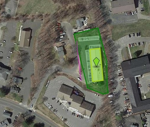
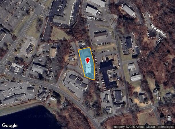
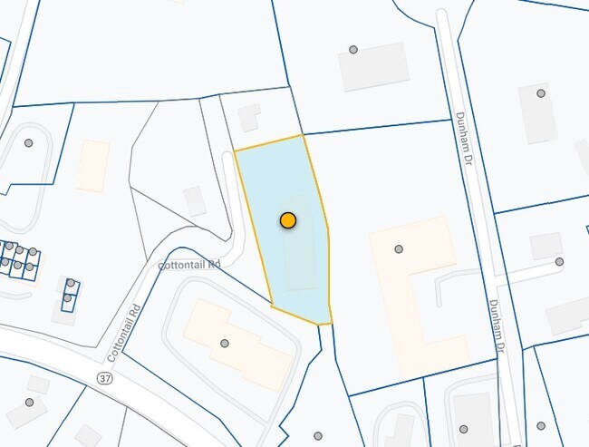
4 Cotton Tail Rd
NFAI-000024-000015-000008-000010
Fairfield
Commercialbuilding
Connecticut
X
8-10
09001C0128F
0.86 AC
2025
Danbury
2025
Westchester/So Connecticut
220300
Bridgeport-Stamford-Norwalk, CT
8,000 SF
DEMOGRAPHICS near 4 Cotton Tail Rd
1 Mile
3 Mile
5 Mile
2024 Total Population
3,065
25,072
77,642
2029 Population
3,095
25,286
77,853
Pop Growth 2024-2029
+ 0.98%
+ 0.85%
+ 0.27%
Average Age
43
43
41
2024 Total Households
1,091
8,819
27,978
HH Growth 2024-2029
+ 1.10%
+ 0.91%
+ 0.25%
Median Household Inc
$128,558
$123,264
$101,063
Avg Household Size
2.80
2.70
2.60
2024 Avg HH Vehicles
2.00
2.00
2.00
Median Home Value
$392,856
$397,211
$371,544
Median Year Built
1972
1969
1971
Nearby Places
Map Layers
Map Styles
 Street
 Aerial
- Restaurants
- Banks
- Shops
- Fitness
- Groceries
PUBLIC TRANSPORTATION
COMMUTER RAIL
Danbury Station (New Haven Line - Metro-North Commuter Railroad Company (Metro-North))
DRIVE
WALK
Distance
Danbury Station (New Haven Line - Metro-North Commuter Railroad Company (Metro-North))
14 min
6.3 mi
Bethel Station (New Haven Line - Metro-North Commuter Railroad Company (Metro-North))
DRIVE
WALK
Distance
Bethel Station (New Haven Line - Metro-North Commuter Railroad Company (Metro-North))
20 min
8.7 mi
AIRPORT
Westchester County
DRIVE
WALK
Distance
Westchester County
52 min
34.9 mi
New York Stewart International
DRIVE
WALK
Distance
New York Stewart International
62 min
41.8 mi
Tweed/New Haven
DRIVE
WALK
Distance
Tweed/New Haven
66 min
43.2 mi
Nearby Properties
Address
Land Use
TOTAL SIZE
Lot Size
Zoning
Address
Land Use
TOTAL SIZE
Lot Size
Zoning
305,658 SF
83.46 AC
2
Address
Land Use
TOTAL SIZE
Lot Size
Zoning
79,869 SF
13.81 AC
G-12
Address
Land Use
TOTAL SIZE
Lot Size
Zoning
18.64 AC
RA40
Address
Land Use
TOTAL SIZE
Lot Size
Zoning
38.23 AC
2
Address
Land Use
TOTAL SIZE
Lot Size
Zoning
136,711 SF
14.20 AC
2
Address
Land Use
TOTAL SIZE
Lot Size
Zoning
59,640 SF
7.82 AC
C
Address
Land Use
TOTAL SIZE
Lot Size
Zoning
56,453 SF
18.01 AC
RA40
Address
Land Use
TOTAL SIZE
Lot Size
Zoning
2,295.68 AC
Address
Land Use
TOTAL SIZE
Lot Size
Zoning
26,800 SF
5 AC
C
Address
Land Use
TOTAL SIZE
Lot Size
Zoning
2,400 SF
1,190.70 AC
R80
Address
Land Use
TOTAL SIZE
Lot Size
Zoning
1.92 AC
MC
Address
Land Use
TOTAL SIZE
Lot Size
Zoning
25,074 SF
5.37 AC
2
Address
Land Use
TOTAL SIZE
Lot Size
Zoning
2.41 AC
C
Address
Land Use
TOTAL SIZE
Lot Size
Zoning
23,477 SF
10.93 AC
RA20
Address
Land Use
TOTAL SIZE
Lot Size
Zoning
0.80 AC
1
Address
Land Use
TOTAL SIZE
Lot Size
Zoning
11,298 SF
2.29 AC
C
Address
Land Use
TOTAL SIZE
Lot Size
Zoning
19,929 SF
1.65 AC
C
Address
Land Use
TOTAL SIZE
Lot Size
Zoning
221.76 AC
2
Address
Land Use
TOTAL SIZE
Lot Size
Zoning
5,794 SF
2.47 AC
RA-80
Address
Land Use
TOTAL SIZE
Lot Size
Zoning
6,035 SF
6.07 AC
RA40
Address
Land Use
TOTAL SIZE
Lot Size
Zoning
227 AC
1
Address
Land Use
TOTAL SIZE
Lot Size
Zoning
12,000 SF
1.56 AC
C
Address
Land Use
TOTAL SIZE
Lot Size
Zoning
0.67 AC
MC
Address
Land Use
TOTAL SIZE
Lot Size
Zoning
2.30 AC
I
Address
Land Use
TOTAL SIZE
Lot Size
Zoning
34,340 SF
2.73 AC
I
Address
Land Use
TOTAL SIZE
Lot Size
Zoning
7,500 SF
1.22 AC
C
Address
Land Use
TOTAL SIZE
Lot Size
Zoning
0.55 AC
1
Address
Land Use
TOTAL SIZE
Lot Size
Zoning
2,600 SF
1.01 AC
R-7
Address
Land Use
TOTAL SIZE
Lot Size
Zoning
0.37 AC
1
Address
Land Use
TOTAL SIZE
Lot Size
Zoning
2.14 AC
1
The World's #1 Commercial Real Estate Marketplace
Connect with us
© 2025 CoStar Group
The information above has been obtained from sources believed reliable. While we do not doubt its accuracy we have not verified it and make no guarantee, warranty or representation about it. It is your responsibility to independently confirm its accuracy and completeness. Any projections, opinions, assumptions, or estimates used are for example only and do not represent the current or future performance of the property. The value of this transaction to you depends on tax and other factors which should be evaluated by your tax, financial, and legal advisors. You and your advisors should conduct a careful, independent investigation of the property to determine to your satisfaction the suitability of the property for your needs.