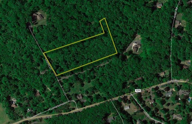
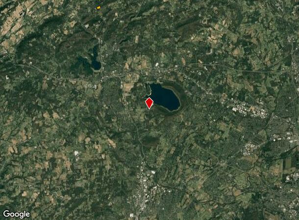
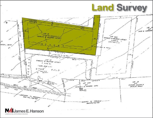
Property Record
4 Country Pl, Lebanon, NJ 08833
NEARBY LISTINGS FOR SALE OR LEASE
Property Detail
4 Country Pl
19-00035-0000-00016
Hunterdon
Vacantlandnec
New Jersey
X
16
34019C0108F
5.01 AC
2024
Route 78 West
2025
Northern New Jersey
011004
Newark, NJ-PA
DEMOGRAPHICS near 4 Country Pl
1 Mile
3 Mile
5 Mile
2024 Total Population
672
9,404
31,205
2029 Population
675
9,511
31,605
Pop Growth 2024-2029
+ 0.45%
+ 1.14%
+ 1.28%
Average Age
44
44
43
2024 Total Households
248
3,731
11,716
HH Growth 2024-2029
+ 0.40%
+ 1.26%
+ 1.40%
Median Household Inc
$117,261
$111,726
$105,807
Avg Household Size
2.70
2.40
2.50
2024 Avg HH Vehicles
3.00
2.00
2.00
Median Home Value
$426,666
$376,917
$361,817
Median Year Built
1974
1972
1971
Nearby Places
Map Layers
Map Styles
 Street
 Aerial
- Restaurants
- Banks
- Shops
- Fitness
- Groceries
PUBLIC TRANSPORTATION
COMMUTER RAIL
Lebanon (Raritan Valley Line - NJ Transit Commuter Rail (NJ Transit))
DRIVE
WALK
Distance
Lebanon (Raritan Valley Line - NJ Transit Commuter Rail (NJ Transit))
12 min
4.9 mi
Annandale (Raritan Valley Line - NJ Transit Commuter Rail (NJ Transit))
DRIVE
WALK
Distance
Annandale (Raritan Valley Line - NJ Transit Commuter Rail (NJ Transit))
12 min
5.4 mi
AIRPORT
Trenton Mercer
DRIVE
WALK
Distance
Trenton Mercer
46 min
27.8 mi
Freight Ports
New York Container Terminal
DRIVE
WALK
Distance
New York Container Terminal
67 min
46.9 mi
SALE & LEASE HISTORY
LISTING DATE
SALE/LEASE

Nov 28, 2018
For Sale
Nearby Properties
Address
Land Use
TOTAL SIZE
Lot Size
Zoning
Address
Land Use
TOTAL SIZE
Lot Size
Zoning
84.62 AC
ROM1
Address
Land Use
TOTAL SIZE
Lot Size
Zoning
3,703.19 AC
RC
Address
Land Use
TOTAL SIZE
Lot Size
Zoning
49.26 AC
RR4S
Address
Land Use
TOTAL SIZE
Lot Size
Zoning
6 AC
ROM1
Address
Land Use
TOTAL SIZE
Lot Size
Zoning
9,408 SF
37 AC
ROM1
Address
Land Use
TOTAL SIZE
Lot Size
Zoning
10.20 AC
OB1
Address
Land Use
TOTAL SIZE
Lot Size
Zoning
1,620 SF
15.85 AC
C2
Address
Land Use
TOTAL SIZE
Lot Size
Zoning
8.50 AC
Address
Land Use
TOTAL SIZE
Lot Size
Zoning
9,200 SF
10.95 AC
Address
Land Use
TOTAL SIZE
Lot Size
Zoning
7,782 SF
10 AC
ROM2
Address
Land Use
TOTAL SIZE
Lot Size
Zoning
244 SF
29.92 AC
RR4S
Address
Land Use
TOTAL SIZE
Lot Size
Zoning
2.19 AC
Address
Land Use
TOTAL SIZE
Lot Size
Zoning
0.83 AC
Address
Land Use
TOTAL SIZE
Lot Size
Zoning
10.44 AC
PUD
Address
Land Use
TOTAL SIZE
Lot Size
Zoning
46.81 AC
AR
Address
Land Use
TOTAL SIZE
Lot Size
Zoning
6.50 AC
Address
Land Use
TOTAL SIZE
Lot Size
Zoning
2,087 SF
4.12 AC
ROM2
Address
Land Use
TOTAL SIZE
Lot Size
Zoning
6,618 SF
43.45 AC
RC
Address
Land Use
TOTAL SIZE
Lot Size
Zoning
169.33 AC
RC
Address
Land Use
TOTAL SIZE
Lot Size
Zoning
5.80 AC
OB1
Address
Land Use
TOTAL SIZE
Lot Size
Zoning
98.91 AC
ROM1
Address
Land Use
TOTAL SIZE
Lot Size
Zoning
15,876 SF
1.94 AC
ROM1
Address
Land Use
TOTAL SIZE
Lot Size
Zoning
22,358 SF
2.81 AC
C1
Address
Land Use
TOTAL SIZE
Lot Size
Zoning
1.52 AC
Address
Land Use
TOTAL SIZE
Lot Size
Zoning
3,683 SF
4.84 AC
C1
Address
Land Use
TOTAL SIZE
Lot Size
Zoning
8,148 SF
7.75 AC
R-1
Address
Land Use
TOTAL SIZE
Lot Size
Zoning
1,672 SF
134.27 AC
SRR
Address
Land Use
TOTAL SIZE
Lot Size
Zoning
2,598 SF
4.32 AC
C2
Address
Land Use
TOTAL SIZE
Lot Size
Zoning
2.09 AC
Address
Land Use
TOTAL SIZE
Lot Size
Zoning
800 SF
0.95 AC
The World's #1 Commercial Real Estate Marketplace
Connect with us
© 2025 CoStar Group
The information above has been obtained from sources believed reliable. While we do not doubt its accuracy we have not verified it and make no guarantee, warranty or representation about it. It is your responsibility to independently confirm its accuracy and completeness. Any projections, opinions, assumptions, or estimates used are for example only and do not represent the current or future performance of the property. The value of this transaction to you depends on tax and other factors which should be evaluated by your tax, financial, and legal advisors. You and your advisors should conduct a careful, independent investigation of the property to determine to your satisfaction the suitability of the property for your needs.