Property Record
4 Craftsman Rd, East Windsor, CT 06088
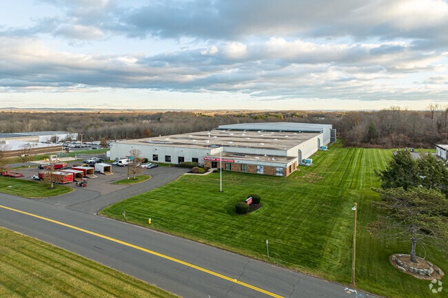

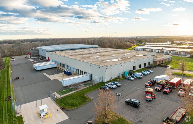
Property Detail
4 Craftsman Rd
EWIN-000083-000019-000111A
Capitol
Industrialgeneral
Connecticut
M-1
111a
B and X Area of moderate flood hazard, usually the area between the limits of the 100-year and 500-year floods.
10 AC
2025
East Windsor
2025
Hartford
484100
Hartford-West Hartford-East Hartford, CT
121,455 SF
NEARBY LISTINGS FOR SALE OR LEASE
DEMOGRAPHICS near 4 Craftsman Rd
1 mile
3 mile
5 mile
2025 Total Population
2,019
22,191
59,074
2030 Population
2,048
22,621
60,245
Pop Growth 2025-2030
+ 1.44%
+ 1.94%
+ 1.98%
Average Age
43
44
44
2025 Total Households
937
9,735
24,622
HH Growth 2025-2030
+ 1.49%
+ 1.96%
+ 2.01%
Median Household Inc
$85,138
$91,680
$99,419
Avg Household Size
2.10
2.20
2.30
2025 Avg HH Vehicles
2.00
2.00
2.00
Median Home Value
$213,172
$272,024
$295,679
Median Year Built
1981
1969
1970
Nearby Places
Map Layers
Map Styles
 Street
 Aerial
Layers
 Traffic
 Biking
Places
Listings with unknown addresses are not visible on the map
- Restaurants
- Banks
- Shops
- Fitness
- Groceries
PUBLIC TRANSPORTATION
COMMUTER RAIL
Windsor Locks (Hartford Line - CT Rail (CTRail))
Drive
Walk
Distance
Windsor Locks (Hartford Line - CT Rail (CTRail))
6 min
2.9 mi
Drive
Walk
Distance
15 min
8.6 mi
AIRPORT
Bradley International
Drive
Walk
Distance
Bradley International
24 min
8.9 mi
Nearby Properties
Address
Land Use
TOTAL SIZE
Lot Size
Zoning
Address
Land Use
TOTAL SIZE
Lot Size
Zoning
492,240 SF
40.80 AC
Address
Land Use
TOTAL SIZE
Lot Size
Zoning
4,418 SF
106 AC
MFDD
Address
Land Use
TOTAL SIZE
Lot Size
Zoning
126,079 SF
38.72 AC
TZ5
Address
Land Use
TOTAL SIZE
Lot Size
Zoning
123,229 SF
4.08 AC
MFSD
Address
Land Use
TOTAL SIZE
Lot Size
Zoning
176,152 SF
27 AC
R44
Address
Land Use
TOTAL SIZE
Lot Size
Zoning
177,366 SF
61.60 AC
RESA
Address
Land Use
TOTAL SIZE
Lot Size
Zoning
190,997 SF
18.47 AC
M-1
Address
Land Use
TOTAL SIZE
Lot Size
Zoning
277,552 SF
40.24 AC
M-1
Address
Land Use
TOTAL SIZE
Lot Size
Zoning
12.14 AC
I
Address
Land Use
TOTAL SIZE
Lot Size
Zoning
117,699 SF
6.83 AC
MFDD
Address
Land Use
TOTAL SIZE
Lot Size
Zoning
2,867 SF
17.27 AC
R-2
Address
Land Use
TOTAL SIZE
Lot Size
Zoning
124,964 SF
RESA
Address
Land Use
TOTAL SIZE
Lot Size
Zoning
11,952 SF
25 AC
MFDD
Address
Land Use
TOTAL SIZE
Lot Size
Zoning
75,238 SF
45.70 AC
R-1
Address
Land Use
TOTAL SIZE
Lot Size
Zoning
25.92 AC
Address
Land Use
TOTAL SIZE
Lot Size
Zoning
44,054 SF
16.87 AC
A-1
Address
Land Use
TOTAL SIZE
Lot Size
Zoning
71,173 SF
14.30 AC
R-2
Address
Land Use
TOTAL SIZE
Lot Size
Zoning
34,045 SF
181.32 AC
B-2
Address
Land Use
TOTAL SIZE
Lot Size
Zoning
14,295 SF
24.45 AC
R-1
Address
Land Use
TOTAL SIZE
Lot Size
Zoning
15.58 AC
RESA
Address
Land Use
TOTAL SIZE
Lot Size
Zoning
150,000 SF
22.20 AC
M-1
Address
Land Use
TOTAL SIZE
Lot Size
Zoning
243,624 SF
12.16 AC
I
Address
Land Use
TOTAL SIZE
Lot Size
Zoning
52.53 AC
Address
Land Use
TOTAL SIZE
Lot Size
Zoning
112,820 SF
8.98 AC
BUS1
Address
Land Use
TOTAL SIZE
Lot Size
Zoning
214,375 SF
3.85 AC
RDRD
Address
Land Use
TOTAL SIZE
Lot Size
Zoning
7,271 SF
14.43 AC
IND2
Address
Land Use
TOTAL SIZE
Lot Size
Zoning
273,865 SF
39.41 AC
M-1
Address
Land Use
TOTAL SIZE
Lot Size
Zoning
83,541 SF
16.30 AC
M-1
Address
Land Use
TOTAL SIZE
Lot Size
Zoning
130,577 SF
15.09 AC
B-1
Address
Land Use
TOTAL SIZE
Lot Size
Zoning
65,329 SF
24.13 AC
RESA
The World's #1 Commercial Real Estate Marketplace
Connect with us
© 2026 CoStar Group
The information above has been obtained from sources believed reliable. While we do not doubt its accuracy we have not verified it and make no guarantee, warranty or representation about it. It is your responsibility to independently confirm its accuracy and completeness. Any projections, opinions, assumptions, or estimates used are for example only and do not represent the current or future performance of the property. The value of this transaction to you depends on tax and other factors which should be evaluated by your tax, financial, and legal advisors. You and your advisors should conduct a careful, independent investigation of the property to determine to your satisfaction the suitability of the property for your needs.