Property Record
4 Cresta Cir, San Rafael, CA 94903
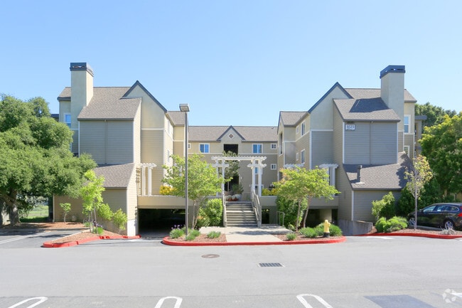

Property Detail
4 Cresta Cir
155-280-04
/B18P63 M CREST MARIN
Multifamilydwelling
Marin
B and X Area of moderate flood hazard, usually the area between the limits of the 100-year and 500-year floods.
California
2025
0.15 AC
2025
Smith Ranch
106001
North Bay/Santa Rosa
6,030 SF
San Rafael, CA
NEARBY LISTINGS FOR SALE OR LEASE
DEMOGRAPHICS near 4 Cresta Cir
1 mile
3 mile
5 mile
2025 Total Population
7,867
48,912
127,719
2030 Population
7,751
48,406
126,101
Pop Growth 2025-2030
(1.47%)
(1.03%)
(1.27%)
Average Age
45
45
44
2025 Total Households
3,270
19,417
49,594
HH Growth 2025-2030
(1.53%)
(1.13%)
(1.28%)
Median Household Inc
$114,856
$125,336
$127,022
Avg Household Size
2.20
2.40
2.50
2025 Avg HH Vehicles
2.00
2.00
2.00
Median Home Value
$881,419
$1,063,262
$1,088,857
Median Year Built
1975
1968
1965
Nearby Places
Map Layers
Map Styles
 Street
 Aerial
Layers
 Traffic
 Biking
Places
Listings with unknown addresses are not visible on the map
- Restaurants
- Banks
- Shops
- Fitness
- Groceries
PUBLIC TRANSPORTATION
COMMUTER RAIL
Smart Marin Civic Center (Main Line - Sonoma Marin Area Rail Transit)
Drive
Walk
Distance
Smart Marin Civic Center (Main Line - Sonoma Marin Area Rail Transit)
4 min
2.1 mi
Smart Novato Hamilton (Main Line - Sonoma Marin Area Rail Transit)
Drive
Walk
Distance
Smart Novato Hamilton (Main Line - Sonoma Marin Area Rail Transit)
7 min
3.7 mi
AIRPORT
San Francisco International
Drive
Walk
Distance
San Francisco International
56 min
35.2 mi
Metro Oakland International
Drive
Walk
Distance
Metro Oakland International
48 min
35.3 mi
Freight Ports
Port of Richmond
Drive
Walk
Distance
Port of Richmond
26 min
16.0 mi
Nearby Properties
Address
Land Use
TOTAL SIZE
Lot Size
Zoning
Address
Land Use
TOTAL SIZE
Lot Size
Zoning
283,663 SF
27.98 AC
Address
Land Use
TOTAL SIZE
Lot Size
Zoning
23.79 AC
Address
Land Use
TOTAL SIZE
Lot Size
Zoning
221,660 SF
9.69 AC
PC
Address
Land Use
TOTAL SIZE
Lot Size
Zoning
16.43 AC
Address
Land Use
TOTAL SIZE
Lot Size
Zoning
146,832 SF
5.50 AC
Address
Land Use
TOTAL SIZE
Lot Size
Zoning
167,392 SF
12.79 AC
Address
Land Use
TOTAL SIZE
Lot Size
Zoning
68,081 SF
3.41 AC
Address
Land Use
TOTAL SIZE
Lot Size
Zoning
132,040 SF
11.74 AC
Address
Land Use
TOTAL SIZE
Lot Size
Zoning
11.63 AC
Address
Land Use
TOTAL SIZE
Lot Size
Zoning
75,888 SF
10.99 AC
Address
Land Use
TOTAL SIZE
Lot Size
Zoning
195,460 SF
6.10 AC
Address
Land Use
TOTAL SIZE
Lot Size
Zoning
Address
Land Use
TOTAL SIZE
Lot Size
Zoning
85,066 SF
1.29 AC
Address
Land Use
TOTAL SIZE
Lot Size
Zoning
192,037 SF
511.90 AC
Address
Land Use
TOTAL SIZE
Lot Size
Zoning
139,073 SF
8.98 AC
Address
Land Use
TOTAL SIZE
Lot Size
Zoning
33,641 SF
1.60 AC
Address
Land Use
TOTAL SIZE
Lot Size
Zoning
45,142 SF
2.32 AC
Address
Land Use
TOTAL SIZE
Lot Size
Zoning
6.39 AC
Address
Land Use
TOTAL SIZE
Lot Size
Zoning
88,828 SF
3.78 AC
Address
Land Use
TOTAL SIZE
Lot Size
Zoning
142,341 SF
5.83 AC
Address
Land Use
TOTAL SIZE
Lot Size
Zoning
94,625 SF
8.96 AC
Address
Land Use
TOTAL SIZE
Lot Size
Zoning
132,813 SF
6.75 AC
Address
Land Use
TOTAL SIZE
Lot Size
Zoning
77,030 SF
3.34 AC
Address
Land Use
TOTAL SIZE
Lot Size
Zoning
124,196 SF
9.77 AC
Address
Land Use
TOTAL SIZE
Lot Size
Zoning
71,268 SF
5.52 AC
Address
Land Use
TOTAL SIZE
Lot Size
Zoning
55,733 SF
4.91 AC
Address
Land Use
TOTAL SIZE
Lot Size
Zoning
Address
Land Use
TOTAL SIZE
Lot Size
Zoning
37,350 SF
2.95 AC
Address
Land Use
TOTAL SIZE
Lot Size
Zoning
109,314 SF
2.65 AC
Address
Land Use
TOTAL SIZE
Lot Size
Zoning
110,000 SF
8.13 AC
The World's #1 Commercial Real Estate Marketplace
Connect with us
© 2026 CoStar Group
The information above has been obtained from sources believed reliable. While we do not doubt its accuracy we have not verified it and make no guarantee, warranty or representation about it. It is your responsibility to independently confirm its accuracy and completeness. Any projections, opinions, assumptions, or estimates used are for example only and do not represent the current or future performance of the property. The value of this transaction to you depends on tax and other factors which should be evaluated by your tax, financial, and legal advisors. You and your advisors should conduct a careful, independent investigation of the property to determine to your satisfaction the suitability of the property for your needs.