Property Record
4 Doane Pl, Pueblo, CO 81001
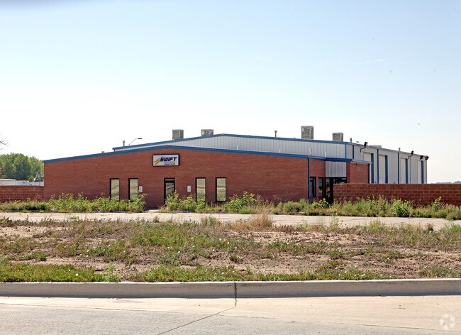


Property Detail
4 Doane Pl
0-3-29-0-01-001
LOT 63 PUEBLO MEMORIAL AIRPORT INDUSTRIAL PARK SUB,FORMERLY 03-000-04-001
Industrialgeneral
Pueblo
I2:IND/MAN
Colorado
B and X Area of moderate flood hazard, usually the area between the limits of the 100-year and 500-year floods.
63
2024
12.19 AC
2024
Colorado East Area
003600
Other Market Areas
14,320 SF
Pueblo, CO
NEARBY LISTINGS FOR SALE OR LEASE
DEMOGRAPHICS near 4 Doane Pl
1 mile
3 mile
5 mile
2025 Total Population
1,141
4,747
11,422
2030 Population
1,192
5,021
11,744
Pop Growth 2025-2030
+ 4.47%
+ 5.77%
+ 2.82%
Average Age
37
42
43
2025 Total Households
413
1,781
4,305
HH Growth 2025-2030
+ 4.60%
+ 5.90%
+ 2.83%
Median Household Inc
$57,575
$78,750
$72,663
Avg Household Size
2.80
2.70
2.60
2025 Avg HH Vehicles
2.00
2.00
2.00
Median Home Value
$199,999
$397,378
$368,469
Median Year Built
1984
1983
1976
Nearby Places
Map Layers
Map Styles
 Street
 Aerial
Layers
 Traffic
 Biking
Places
Listings with unknown addresses are not visible on the map
- Restaurants
- Banks
- Shops
- Fitness
- Groceries
Nearby Properties
Address
Land Use
TOTAL SIZE
Lot Size
Zoning
Address
Land Use
TOTAL SIZE
Lot Size
Zoning
225,504 SF
37.40 AC
I2:IND/MAN
Address
Land Use
TOTAL SIZE
Lot Size
Zoning
1,158,183 SF
84.46 AC
I2:IND/MAN
Address
Land Use
TOTAL SIZE
Lot Size
Zoning
196,492 SF
11.41 AC
I3:IND/HEA
Address
Land Use
TOTAL SIZE
Lot Size
Zoning
84,386 SF
0.11 AC
I1:IND/PAR
Address
Land Use
TOTAL SIZE
Lot Size
Zoning
259,600 SF
44.62 AC
I1:IND/PAR
Address
Land Use
TOTAL SIZE
Lot Size
Zoning
148,405 SF
35.67 AC
I1:IND/PAR
Address
Land Use
TOTAL SIZE
Lot Size
Zoning
191,905 SF
11.20 AC
I1:IND/PAR
Address
Land Use
TOTAL SIZE
Lot Size
Zoning
29,337 SF
6.02 AC
I2:IND/MAN
Address
Land Use
TOTAL SIZE
Lot Size
Zoning
128,100 SF
17.28 AC
I2:IND/MAN
Address
Land Use
TOTAL SIZE
Lot Size
Zoning
288,672 SF
27.56 AC
I2:IND/MAN
Address
Land Use
TOTAL SIZE
Lot Size
Zoning
140,480 SF
10.03 AC
I2:IND/MAN
Address
Land Use
TOTAL SIZE
Lot Size
Zoning
63,500 SF
3.80 AC
I2:IND/MAN
Address
Land Use
TOTAL SIZE
Lot Size
Zoning
68,999 SF
4.47 AC
I2:IND/MAN
Address
Land Use
TOTAL SIZE
Lot Size
Zoning
155,800 SF
16.46 AC
I1:IND/PAR
Address
Land Use
TOTAL SIZE
Lot Size
Zoning
26,400 SF
4.87 AC
I2:IND/MAN
Address
Land Use
TOTAL SIZE
Lot Size
Zoning
76.72 AC
I-2
Address
Land Use
TOTAL SIZE
Lot Size
Zoning
29,160 SF
7.66 AC
I1:IND/PAR
Address
Land Use
TOTAL SIZE
Lot Size
Zoning
7,706 SF
1.80 AC
I2:IND/MAN
Address
Land Use
TOTAL SIZE
Lot Size
Zoning
50,720 SF
6.15 AC
I2:IND/MAN
Address
Land Use
TOTAL SIZE
Lot Size
Zoning
80,700 SF
9.89 AC
A2:AG/1&2
Address
Land Use
TOTAL SIZE
Lot Size
Zoning
31,328 SF
5.22 AC
I1:IND/PAR
Address
Land Use
TOTAL SIZE
Lot Size
Zoning
128,994 SF
8.77 AC
I2:IND/MAN
Address
Land Use
TOTAL SIZE
Lot Size
Zoning
50,720 SF
6.23 AC
I2:IND/MAN
Address
Land Use
TOTAL SIZE
Lot Size
Zoning
135,019 SF
19.10 AC
I2:IND/MAN
Address
Land Use
TOTAL SIZE
Lot Size
Zoning
4,970 SF
1 AC
A-3
Address
Land Use
TOTAL SIZE
Lot Size
Zoning
3,805 SF
1.77 AC
A-4
Address
Land Use
TOTAL SIZE
Lot Size
Zoning
36,825 SF
8.23 AC
I2:IND/MAN
Address
Land Use
TOTAL SIZE
Lot Size
Zoning
146,480 SF
20 AC
I3:IND/HEA
Address
Land Use
TOTAL SIZE
Lot Size
Zoning
50,000 SF
10.12 AC
I2:IND/MAN
The World's #1 Commercial Real Estate Marketplace
Connect with us
© 2026 CoStar Group
The information above has been obtained from sources believed reliable. While we do not doubt its accuracy we have not verified it and make no guarantee, warranty or representation about it. It is your responsibility to independently confirm its accuracy and completeness. Any projections, opinions, assumptions, or estimates used are for example only and do not represent the current or future performance of the property. The value of this transaction to you depends on tax and other factors which should be evaluated by your tax, financial, and legal advisors. You and your advisors should conduct a careful, independent investigation of the property to determine to your satisfaction the suitability of the property for your needs.