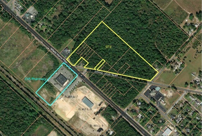
Property Record
4 E Jimmie Leeds Rd, Galloway, NJ 08205

NEARBY LISTINGS FOR SALE OR LEASE
Property Detail
4 E Jimmie Leeds Rd
11-00470-0000-00030
Atlantic
Vacantlandnec
New Jersey
ARE
22
34001C0305F
4.10 AC
2024
Atlantic City/Hammonton
2025
Philadelphia
000001
Atlantic City-Hammonton, NJ
DEMOGRAPHICS near 4 E Jimmie Leeds Rd
1 Mile
3 Mile
5 Mile
2024 Total Population
2,236
12,315
50,950
2029 Population
2,186
12,069
50,038
Pop Growth 2024-2029
(2.24%)
(2.00%)
(1.79%)
Average Age
36
37
39
2024 Total Households
587
3,234
17,548
HH Growth 2024-2029
(3.58%)
(3.22%)
(2.51%)
Median Household Inc
$84,103
$88,550
$71,837
Avg Household Size
2.80
2.80
2.60
2024 Avg HH Vehicles
2.00
2.00
2.00
Median Home Value
$236,296
$235,801
$218,755
Median Year Built
1993
1992
1986
Nearby Places
Map Layers
Map Styles
 Street
 Aerial
- Restaurants
- Banks
- Shops
- Fitness
- Groceries
PUBLIC TRANSPORTATION
COMMUTER RAIL
Egg Harbor City (Atlantic City Line - NJ Transit Commuter Rail (NJ Transit))
DRIVE
WALK
Distance
Egg Harbor City (Atlantic City Line - NJ Transit Commuter Rail (NJ Transit))
7 min
5.0 mi
Absecon (Atlantic City Line - NJ Transit Commuter Rail (NJ Transit))
DRIVE
WALK
Distance
Absecon (Atlantic City Line - NJ Transit Commuter Rail (NJ Transit))
7 min
6.2 mi
AIRPORT
Atlantic City International
DRIVE
WALK
Distance
Atlantic City International
27 min
6.2 mi
Freight Ports
Broadway Terminal - Pier 5
DRIVE
WALK
Distance
Broadway Terminal - Pier 5
58 min
44.6 mi
SALE & LEASE HISTORY
LISTING DATE
SALE/LEASE

Apr 17, 2023
For Sale
Nearby Properties
Address
Land Use
TOTAL SIZE
Lot Size
Zoning
Address
Land Use
TOTAL SIZE
Lot Size
Zoning
67,752 SF
2,381.05 AC
Address
Land Use
TOTAL SIZE
Lot Size
Zoning
1.57 AC
GI
Address
Land Use
TOTAL SIZE
Lot Size
Zoning
Address
Land Use
TOTAL SIZE
Lot Size
Zoning
16.75 AC
Address
Land Use
TOTAL SIZE
Lot Size
Zoning
2,824 SF
GI
Address
Land Use
TOTAL SIZE
Lot Size
Zoning
27 AC
GI
Address
Land Use
TOTAL SIZE
Lot Size
Zoning
14.32 AC
PO
Address
Land Use
TOTAL SIZE
Lot Size
Zoning
35.65 AC
IRD
Address
Land Use
TOTAL SIZE
Lot Size
Zoning
1.74 AC
GI
Address
Land Use
TOTAL SIZE
Lot Size
Zoning
3.66 AC
GI
Address
Land Use
TOTAL SIZE
Lot Size
Zoning
1.89 AC
GI
Address
Land Use
TOTAL SIZE
Lot Size
Zoning
9.96 AC
GI
Address
Land Use
TOTAL SIZE
Lot Size
Zoning
484.98 AC
Address
Land Use
TOTAL SIZE
Lot Size
Zoning
4.50 AC
R-1
Address
Land Use
TOTAL SIZE
Lot Size
Zoning
9.53 AC
PO
Address
Land Use
TOTAL SIZE
Lot Size
Zoning
16.39 AC
R-1
Address
Land Use
TOTAL SIZE
Lot Size
Zoning
8.67 AC
PO
Address
Land Use
TOTAL SIZE
Lot Size
Zoning
Address
Land Use
TOTAL SIZE
Lot Size
Zoning
831.11 AC
FED
Address
Land Use
TOTAL SIZE
Lot Size
Zoning
Address
Land Use
TOTAL SIZE
Lot Size
Zoning
6.69 AC
PO
Address
Land Use
TOTAL SIZE
Lot Size
Zoning
83.64 AC
Address
Land Use
TOTAL SIZE
Lot Size
Zoning
1,056 SF
11.56 AC
I
Address
Land Use
TOTAL SIZE
Lot Size
Zoning
3.93 AC
PO
Address
Land Use
TOTAL SIZE
Lot Size
Zoning
1.68 AC
PO
Address
Land Use
TOTAL SIZE
Lot Size
Zoning
4,652 SF
14.80 AC
HC-2
Address
Land Use
TOTAL SIZE
Lot Size
Zoning
1,390 SF
1.92 AC
HC-2
Address
Land Use
TOTAL SIZE
Lot Size
Zoning
Address
Land Use
TOTAL SIZE
Lot Size
Zoning
4.26 AC
PO
Address
Land Use
TOTAL SIZE
Lot Size
Zoning
136.80 AC
The World's #1 Commercial Real Estate Marketplace
Connect with us
© 2025 CoStar Group
The information above has been obtained from sources believed reliable. While we do not doubt its accuracy we have not verified it and make no guarantee, warranty or representation about it. It is your responsibility to independently confirm its accuracy and completeness. Any projections, opinions, assumptions, or estimates used are for example only and do not represent the current or future performance of the property. The value of this transaction to you depends on tax and other factors which should be evaluated by your tax, financial, and legal advisors. You and your advisors should conduct a careful, independent investigation of the property to determine to your satisfaction the suitability of the property for your needs.